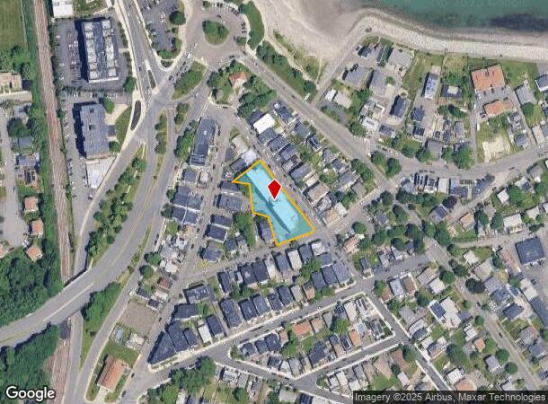
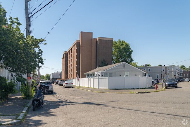
Property Record
45 Dolphin Ave, Revere, MA 02151

NEARBY LISTINGS FOR SALE OR LEASE
-
-
-
-
-
-
-
No Photo
-
View all Revere listings for sale on LoopNet.com
Property Detail
45 Dolphin Ave
REVE-000002-000051-000003
Suffolk
Governmentalpublicusegeneral
Massachusetts
X
3
25025C0038J
0.65 AC
0
Beachmont
2025
Boston
170800
Boston-Cambridge-Newton, MA-NH
69,921 SF
DEMOGRAPHICS near 45 Dolphin Ave
1 Mile
3 Mile
5 Mile
2024 Total Population
18,459
141,083
400,124
2029 Population
17,418
132,148
385,371
Pop Growth 2024-2029
(5.64%)
(6.33%)
(3.69%)
Average Age
39
39
39
2024 Total Households
6,861
50,693
161,993
HH Growth 2024-2029
(5.70%)
(6.76%)
(3.72%)
Median Household Inc
$64,152
$71,945
$82,401
Avg Household Size
2.60
2.70
2.40
2024 Avg HH Vehicles
1.00
1.00
1.00
Median Home Value
$478,679
$536,902
$616,607
Median Year Built
1957
1949
1954
Nearby Places
Map Layers
Map Styles
 Street
 Aerial
- Restaurants
- Banks
- Shops
- Fitness
- Groceries
PUBLIC TRANSPORTATION
TRANSIT/SUBWAY
Beachmont Station (Blue Line - Massachusetts Bay Transportation Authority Subway (The T))
DRIVE
WALK
Distance
Beachmont Station (Blue Line - Massachusetts Bay Transportation Authority Subway (The T))
2 min
7 min
0.3 mi
Revere Beach Station (Blue Line - Massachusetts Bay Transportation Authority Subway (The T))
DRIVE
WALK
Distance
Revere Beach Station (Blue Line - Massachusetts Bay Transportation Authority Subway (The T))
3 min
13 min
0.7 mi
Suffolk Downs Station (Blue Line - Massachusetts Bay Transportation Authority Subway (The T))
DRIVE
WALK
Distance
Suffolk Downs Station (Blue Line - Massachusetts Bay Transportation Authority Subway (The T))
3 min
18 min
0.9 mi
COMMUTER RAIL
DRIVE
WALK
Distance
8 min
3.8 mi
River Works (Newburyport/Rockport Line - Massachusetts Bay Transportation Authority Commuter Rail (Purple Line))
DRIVE
WALK
Distance
River Works (Newburyport/Rockport Line - Massachusetts Bay Transportation Authority Commuter Rail (Purple Line))
11 min
4.7 mi
AIRPORT
General Edward Lawrence Logan International
DRIVE
WALK
Distance
General Edward Lawrence Logan International
10 min
4.8 mi
Freight Ports
Port of Boston
DRIVE
WALK
Distance
Port of Boston
16 min
7.5 mi
Nearby Properties
Address
Land Use
TOTAL SIZE
Lot Size
Zoning
Address
Land Use
TOTAL SIZE
Lot Size
Zoning
171,791 SF
166.88 AC
E
Address
Land Use
TOTAL SIZE
Lot Size
Zoning
247,013 SF
1.13 AC
RC2
Address
Land Use
TOTAL SIZE
Lot Size
Zoning
234,450 SF
3.49 AC
I
Address
Land Use
TOTAL SIZE
Lot Size
Zoning
211,294 SF
1.66 AC
RC2
Address
Land Use
TOTAL SIZE
Lot Size
Zoning
224,840 SF
2.18 AC
RC1
Address
Land Use
TOTAL SIZE
Lot Size
Zoning
226,431 SF
4.31 AC
HB
Address
Land Use
TOTAL SIZE
Lot Size
Zoning
1.65 AC
RC2
Address
Land Use
TOTAL SIZE
Lot Size
Zoning
6.02 AC
TED
Address
Land Use
TOTAL SIZE
Lot Size
Zoning
362,358 SF
3.44 AC
CTED
Address
Land Use
TOTAL SIZE
Lot Size
Zoning
379,857 SF
7.16 AC
R2
Address
Land Use
TOTAL SIZE
Lot Size
Zoning
422,028 SF
16.10 AC
RB
Address
Land Use
TOTAL SIZE
Lot Size
Zoning
232,943 SF
3.87 AC
Address
Land Use
TOTAL SIZE
Lot Size
Zoning
227,673 SF
1.75 AC
R3
Address
Land Use
TOTAL SIZE
Lot Size
Zoning
172,043 SF
1.13 AC
RC1
Address
Land Use
TOTAL SIZE
Lot Size
Zoning
191,523 SF
2.70 AC
Address
Land Use
TOTAL SIZE
Lot Size
Zoning
5,668 SF
20.05 AC
A
Address
Land Use
TOTAL SIZE
Lot Size
Zoning
391,884 SF
108.79 AC
C
Address
Land Use
TOTAL SIZE
Lot Size
Zoning
738 SF
20.71 AC
PORT
Address
Land Use
TOTAL SIZE
Lot Size
Zoning
208,663 SF
2.56 AC
DD
Address
Land Use
TOTAL SIZE
Lot Size
Zoning
449,900 SF
3.38 AC
I
Address
Land Use
TOTAL SIZE
Lot Size
Zoning
303,232 SF
2.52 AC
CTED
Address
Land Use
TOTAL SIZE
Lot Size
Zoning
290,748 SF
7.04 AC
R2
Address
Land Use
TOTAL SIZE
Lot Size
Zoning
14.79 AC
INDUST
Address
Land Use
TOTAL SIZE
Lot Size
Zoning
214,895 SF
3.30 AC
A
Address
Land Use
TOTAL SIZE
Lot Size
Zoning
241,299 SF
10.26 AC
RB
Address
Land Use
TOTAL SIZE
Lot Size
Zoning
192,881 SF
6.08 AC
C
Address
Land Use
TOTAL SIZE
Lot Size
Zoning
224,868 SF
9.08 AC
I
Address
Land Use
TOTAL SIZE
Lot Size
Zoning
144,848 SF
13.85 AC
IP
Address
Land Use
TOTAL SIZE
Lot Size
Zoning
192,031 SF
8.34 AC
Address
Land Use
TOTAL SIZE
Lot Size
Zoning
130,120 SF
0.83 AC
RC2
The World's #1 Commercial Real Estate Marketplace
Connect with us
© 2025 CoStar Group
The information above has been obtained from sources believed reliable. While we do not doubt its accuracy we have not verified it and make no guarantee, warranty or representation about it. It is your responsibility to independently confirm its accuracy and completeness. Any projections, opinions, assumptions, or estimates used are for example only and do not represent the current or future performance of the property. The value of this transaction to you depends on tax and other factors which should be evaluated by your tax, financial, and legal advisors. You and your advisors should conduct a careful, independent investigation of the property to determine to your satisfaction the suitability of the property for your needs.