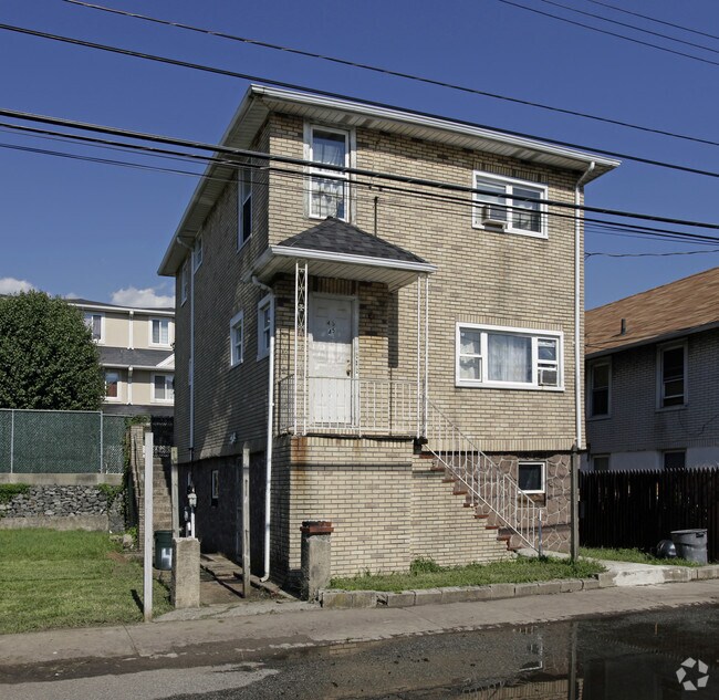
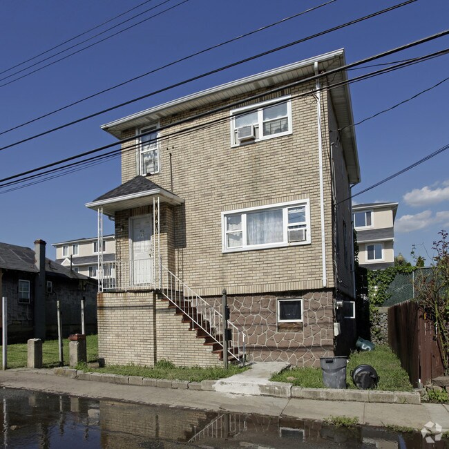
Property Record
45 Doty Ave, Staten Island, NY 10305

NEARBY LISTINGS FOR SALE OR LEASE
Property Detail
45 Doty Ave
03124-0008
Staten Island
Multifamilydwelling
New York
AE
8
3604970329F
0.48 AC
2024
Arrochar
2025
Long Island (New York)
007400
New York-Jersey City-White Plains, NY-NJ
3,150 SF
DEMOGRAPHICS near 45 Doty Ave
1 mile
3 mile
5 mile
2024 Total Population
21,149
177,036
807,755
2029 Population
21,081
173,046
762,440
Pop Growth 2024-2029
(0.32%)
(2.25%)
(5.61%)
Average Age
40
41
40
2024 Total Households
7,130
65,575
275,138
HH Growth 2024-2029
(0.27%)
(2.62%)
(5.74%)
Median Household Inc
$73,727
$78,295
$66,854
Avg Household Size
2.90
2.60
2.80
2024 Avg HH Vehicles
1.00
1.00
1.00
Median Home Value
$642,483
$683,954
$729,674
Median Year Built
1976
1961
1951
Nearby Places
Map Layers
Map Styles
 Street
 Aerial
Transit
 Traffic
 Biking
Places
Listings with unknown addresses are not visible on the map
- Restaurants
- Banks
- Shops
- Fitness
- Groceries
PUBLIC TRANSPORTATION
COMMUTER RAIL
Grasmere (Staten Island Railway - New York MTA Subway (The Subway))
Drive
Walk
Distance
Grasmere (Staten Island Railway - New York MTA Subway (The Subway))
6 min
1.7 mi
Old Town (Staten Island Railway - New York MTA Subway (The Subway))
Drive
Walk
Distance
Old Town (Staten Island Railway - New York MTA Subway (The Subway))
6 min
1.9 mi
AIRPORT
Newark Liberty International
Drive
Walk
Distance
Newark Liberty International
30 min
17.7 mi
LaGuardia
Drive
Walk
Distance
LaGuardia
35 min
20.0 mi
John F Kennedy International
Drive
Walk
Distance
John F Kennedy International
38 min
22.5 mi
Freight Ports
New York Container Terminal
Drive
Walk
Distance
New York Container Terminal
16 min
8.4 mi
Nearby Properties
Address
Land Use
TOTAL SIZE
Lot Size
Zoning
Address
Land Use
TOTAL SIZE
Lot Size
Zoning
1,524,659 SF
170.96 AC
R4
Address
Land Use
TOTAL SIZE
Lot Size
Zoning
640,077 SF
19.34 AC
R3-1
Address
Land Use
TOTAL SIZE
Lot Size
Zoning
340,068 SF
0.58 AC
C2-8
Address
Land Use
TOTAL SIZE
Lot Size
Zoning
340,068 SF
0.58 AC
C2-8
Address
Land Use
TOTAL SIZE
Lot Size
Zoning
135,000 SF
117.71 AC
PARK
Address
Land Use
TOTAL SIZE
Lot Size
Zoning
236,591 SF
207.66 AC
R3-2
Address
Land Use
TOTAL SIZE
Lot Size
Zoning
286,000 SF
12.63 AC
PARK
Address
Land Use
TOTAL SIZE
Lot Size
Zoning
521,405 SF
52.79 AC
R3-1
Address
Land Use
TOTAL SIZE
Lot Size
Zoning
421,275 SF
18.95 AC
R3-2
Address
Land Use
TOTAL SIZE
Lot Size
Zoning
111,000 SF
186.03 AC
PARK
Address
Land Use
TOTAL SIZE
Lot Size
Zoning
310,068 SF
0.58 AC
C2-8
Address
Land Use
TOTAL SIZE
Lot Size
Zoning
152,440 SF
23.07 AC
R4B
Address
Land Use
TOTAL SIZE
Lot Size
Zoning
240 SF
47.41 AC
R3-2
Address
Land Use
TOTAL SIZE
Lot Size
Zoning
476,145 SF
50.97 AC
R3-1
Address
Land Use
TOTAL SIZE
Lot Size
Zoning
43,068 SF
216.83 AC
PARK
Address
Land Use
TOTAL SIZE
Lot Size
Zoning
146,855 SF
16.50 AC
R3-1
Address
Land Use
TOTAL SIZE
Lot Size
Zoning
16,570 SF
240.82 AC
PARK
Address
Land Use
TOTAL SIZE
Lot Size
Zoning
414,400 SF
2.70 AC
R7A
Address
Land Use
TOTAL SIZE
Lot Size
Zoning
77,502 SF
1.29 AC
R3-1
Address
Land Use
TOTAL SIZE
Lot Size
Zoning
900 SF
50 AC
R1-1
Address
Land Use
TOTAL SIZE
Lot Size
Zoning
654,030 SF
13.94 AC
R5
Address
Land Use
TOTAL SIZE
Lot Size
Zoning
330,780 SF
676.51 AC
C4-2A
Address
Land Use
TOTAL SIZE
Lot Size
Zoning
151,637 SF
7.41 AC
C4-1
Address
Land Use
TOTAL SIZE
Lot Size
Zoning
45,570 SF
206.38 AC
PARKUS
Address
Land Use
TOTAL SIZE
Lot Size
Zoning
7,410 SF
44.60 AC
R1-1
Address
Land Use
TOTAL SIZE
Lot Size
Zoning
151,080 SF
17.59 AC
R1-2
Address
Land Use
TOTAL SIZE
Lot Size
Zoning
261,000 SF
1.43 AC
R7A
Address
Land Use
TOTAL SIZE
Lot Size
Zoning
261,000 SF
1.43 AC
R7A
Address
Land Use
TOTAL SIZE
Lot Size
Zoning
261,000 SF
1.43 AC
R7A
Address
Land Use
TOTAL SIZE
Lot Size
Zoning
261,000 SF
1.43 AC
R7A
The World's #1 Commercial Real Estate Marketplace
Connect with us
© 2026 CoStar Group
The information above has been obtained from sources believed reliable. While we do not doubt its accuracy we have not verified it and make no guarantee, warranty or representation about it. It is your responsibility to independently confirm its accuracy and completeness. Any projections, opinions, assumptions, or estimates used are for example only and do not represent the current or future performance of the property. The value of this transaction to you depends on tax and other factors which should be evaluated by your tax, financial, and legal advisors. You and your advisors should conduct a careful, independent investigation of the property to determine to your satisfaction the suitability of the property for your needs.