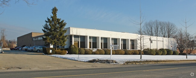
Property Record
45 Engineers Rd, Hauppauge, NY 11788

NEARBY LISTINGS FOR SALE OR LEASE
Property Detail
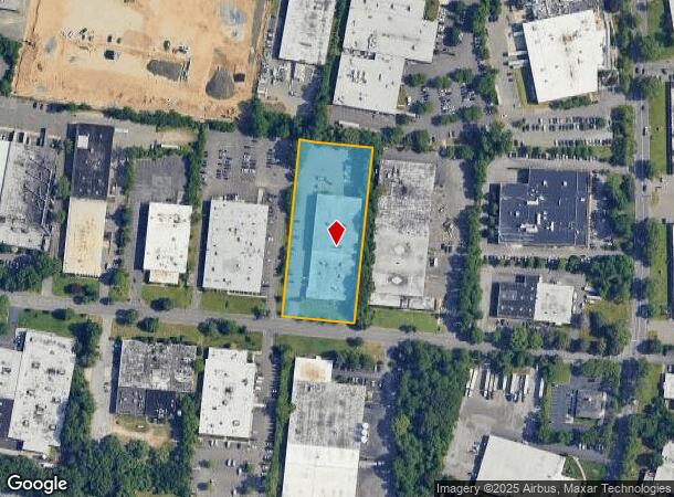
45 Engineers Rd
Nassau County-Suffolk County, NY
Map Of Vanderbilt Industrial Park Sectio
0800-185-00-01-00-027-000
22-859651 TC-94 *4716 P/L 37 VANDERBILT INDUST PARK SE
Warehouse
Suffolk
X
New York
36103C0655H
27
2024
2.20 AC
2024
Hauppauge
135209
Long Island (New York)
DEMOGRAPHICS near 45 Engineers Rd
1 Mile
3 Mile
5 Mile
2024 Total Population
5,847
95,751
239,342
2029 Population
5,716
93,232
233,364
Pop Growth 2024-2029
(2.24%)
(2.63%)
(2.50%)
Average Age
39
38
40
2024 Total Households
1,669
25,648
68,790
HH Growth 2024-2029
(2.22%)
(2.73%)
(2.60%)
Median Household Inc
$133,672
$118,370
$125,417
Avg Household Size
3.30
3.40
3.20
2024 Avg HH Vehicles
2.00
2.00
2.00
Median Home Value
$549,458
$478,983
$492,062
Median Year Built
1966
1966
1966
Nearby Places
Map Layers
Map Styles
 Street
 Aerial
- Restaurants
- Banks
- Shops
- Fitness
- Groceries
PUBLIC TRANSPORTATION
COMMUTER RAIL
Central Islip Station (Ronkonkoma Branch - Long Island Rail Road)
DRIVE
WALK
Distance
Central Islip Station (Ronkonkoma Branch - Long Island Rail Road)
8 min
3.4 mi
Brentwood Station (Ronkonkoma Branch - Long Island Rail Road)
DRIVE
WALK
Distance
Brentwood Station (Ronkonkoma Branch - Long Island Rail Road)
9 min
3.5 mi
AIRPORT
Long Island MacArthur
DRIVE
WALK
Distance
Long Island MacArthur
17 min
8.8 mi
John F Kennedy International
DRIVE
WALK
Distance
John F Kennedy International
54 min
39.5 mi
Freight Ports
NY - Red Hook Container Terminal
DRIVE
WALK
Distance
NY - Red Hook Container Terminal
67 min
46.0 mi
SALE & LEASE HISTORY
LISTING DATE
SALE/LEASE

Jan 27, 2020
For Sale
Jan 27, 2020
For Lease
Feb 03, 2020
For Sale
Nearby Properties
Address
Land Use
TOTAL SIZE
Lot Size
Zoning
Address
Land Use
TOTAL SIZE
Lot Size
Zoning
301 SF
3.70 AC
Address
Land Use
TOTAL SIZE
Lot Size
Zoning
97.50 AC
AAA
Address
Land Use
TOTAL SIZE
Lot Size
Zoning
194.82 AC
AAA
Address
Land Use
TOTAL SIZE
Lot Size
Zoning
57.30 AC
AAA
Address
Land Use
TOTAL SIZE
Lot Size
Zoning
22.22 AC
AA
Address
Land Use
TOTAL SIZE
Lot Size
Zoning
52.73 AC
AAA
Address
Land Use
TOTAL SIZE
Lot Size
Zoning
24.10 AC
A
Address
Land Use
TOTAL SIZE
Lot Size
Zoning
196.07 AC
AAA
Address
Land Use
TOTAL SIZE
Lot Size
Zoning
2.79 AC
Address
Land Use
TOTAL SIZE
Lot Size
Zoning
36.66 AC
NULL
Address
Land Use
TOTAL SIZE
Lot Size
Zoning
24.96 AC
Address
Land Use
TOTAL SIZE
Lot Size
Zoning
24.70 AC
AAA
Address
Land Use
TOTAL SIZE
Lot Size
Zoning
5,140 SF
23.39 AC
CA
Address
Land Use
TOTAL SIZE
Lot Size
Zoning
19.70 AC
A
Address
Land Use
TOTAL SIZE
Lot Size
Zoning
21.20 AC
AA
Address
Land Use
TOTAL SIZE
Lot Size
Zoning
15 AC
AA
Address
Land Use
TOTAL SIZE
Lot Size
Zoning
45.56 AC
Address
Land Use
TOTAL SIZE
Lot Size
Zoning
30.50 AC
A
Address
Land Use
TOTAL SIZE
Lot Size
Zoning
8.02 AC
NULL
Address
Land Use
TOTAL SIZE
Lot Size
Zoning
10.20 AC
B
Address
Land Use
TOTAL SIZE
Lot Size
Zoning
14.08 AC
Address
Land Use
TOTAL SIZE
Lot Size
Zoning
10.90 AC
AAA
Address
Land Use
TOTAL SIZE
Lot Size
Zoning
22.84 AC
IND1
Address
Land Use
TOTAL SIZE
Lot Size
Zoning
10.50 AC
NULL
Address
Land Use
TOTAL SIZE
Lot Size
Zoning
6.81 AC
NULL
Address
Land Use
TOTAL SIZE
Lot Size
Zoning
4,624 SF
9.73 AC
A
Address
Land Use
TOTAL SIZE
Lot Size
Zoning
8.83 AC
Address
Land Use
TOTAL SIZE
Lot Size
Zoning
12.80 AC
AAA
Address
Land Use
TOTAL SIZE
Lot Size
Zoning
79.78 AC
AAA
Address
Land Use
TOTAL SIZE
Lot Size
Zoning
8.35 AC
IND1
The World's #1 Commercial Real Estate Marketplace
Connect with us
© 2026 CoStar Group
The information above has been obtained from sources believed reliable. While we do not doubt its accuracy we have not verified it and make no guarantee, warranty or representation about it. It is your responsibility to independently confirm its accuracy and completeness. Any projections, opinions, assumptions, or estimates used are for example only and do not represent the current or future performance of the property. The value of this transaction to you depends on tax and other factors which should be evaluated by your tax, financial, and legal advisors. You and your advisors should conduct a careful, independent investigation of the property to determine to your satisfaction the suitability of the property for your needs.