Property Record
45 Lyme Rd, Hanover, NH 03755

Save to a Folder
{{folder.Name}}
{{folder.ListingIds.length}} Properties
{{folder.ListingIds.length}} Property
Create a New Folder
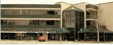
Property Detail
45 Lyme Rd
HNOV-000044-000001-000001
Grafton
Officebuilding
New Hampshire
B1
1
B and X Area of moderate flood hazard, usually the area between the limits of the 100-year and 500-year floods.
1.45 AC
2025
Concord/New Hampshire North Area
2025
Other Market Areas
961603
Lebanon-Claremont, NH-VT
42,882 SF
NEARBY LISTINGS FOR SALE OR LEASE
DEMOGRAPHICS near 45 Lyme Rd
1 mile
3 mile
5 mile
2025 Total Population
2,303
16,533
25,016
2030 Population
2,400
17,198
25,518
Pop Growth 2025-2030
+ 4.21%
+ 4.02%
+ 2.01%
Average Age
46
37
39
2025 Total Households
891
5,349
9,249
HH Growth 2025-2030
+ 4.94%
+ 5.53%
+ 2.44%
Median Household Inc
$151,754
$108,539
$103,640
Avg Household Size
2.30
2.30
2.20
2025 Avg HH Vehicles
2.00
2.00
2.00
Median Home Value
$790,697
$661,433
$506,656
Median Year Built
1986
1992
1987
Nearby Places
Map Layers
Map Styles
 Street
 Aerial
Layers
 Traffic
 Biking
Places
Listings with unknown addresses are not visible on the map
- Restaurants
- Banks
- Shops
- Fitness
- Groceries
PUBLIC TRANSPORTATION
COMMUTER RAIL
White River Junction Amtrak Station (Vermonter - Amtrak)
Drive
Walk
Distance
White River Junction Amtrak Station (Vermonter - Amtrak)
10 min
5.7 mi
Freight Ports
Portland, ME
Drive
Walk
Distance
Portland, ME
202 min
168.2 mi
SALE & LEASE HISTORY
LISTING DATE
SALE/LEASE

Aug 03, 2018
For Lease
Nearby Properties
Address
Land Use
TOTAL SIZE
Lot Size
Zoning
Address
Land Use
TOTAL SIZE
Lot Size
Zoning
470,079 SF
65.50 AC
GR4
Address
Land Use
TOTAL SIZE
Lot Size
Zoning
16,384 SF
4.46 AC
I
Address
Land Use
TOTAL SIZE
Lot Size
Zoning
Address
Land Use
TOTAL SIZE
Lot Size
Zoning
Address
Land Use
TOTAL SIZE
Lot Size
Zoning
0.34 AC
I
Address
Land Use
TOTAL SIZE
Lot Size
Zoning
0.90 AC
I
Address
Land Use
TOTAL SIZE
Lot Size
Zoning
163,845 SF
MC
Address
Land Use
TOTAL SIZE
Lot Size
Zoning
31.50 AC
Address
Land Use
TOTAL SIZE
Lot Size
Zoning
0.53 AC
I
Address
Land Use
TOTAL SIZE
Lot Size
Zoning
430,065 SF
23.35 AC
I
Address
Land Use
TOTAL SIZE
Lot Size
Zoning
49.33 AC
Address
Land Use
TOTAL SIZE
Lot Size
Zoning
194,496 SF
28.26 AC
I
Address
Land Use
TOTAL SIZE
Lot Size
Zoning
1.55 AC
I
Address
Land Use
TOTAL SIZE
Lot Size
Zoning
15,481 SF
1.47 AC
I
Address
Land Use
TOTAL SIZE
Lot Size
Zoning
Address
Land Use
TOTAL SIZE
Lot Size
Zoning
4.30 AC
I
Address
Land Use
TOTAL SIZE
Lot Size
Zoning
15,000 SF
28.14 AC
OL
Address
Land Use
TOTAL SIZE
Lot Size
Zoning
356.40 AC
RL3
Address
Land Use
TOTAL SIZE
Lot Size
Zoning
0.47 AC
I
Address
Land Use
TOTAL SIZE
Lot Size
Zoning
0.46 AC
I
Address
Land Use
TOTAL SIZE
Lot Size
Zoning
1.03 AC
I
Address
Land Use
TOTAL SIZE
Lot Size
Zoning
81,782 SF
35 AC
I
Address
Land Use
TOTAL SIZE
Lot Size
Zoning
0.47 AC
I
Address
Land Use
TOTAL SIZE
Lot Size
Zoning
0.42 AC
I
Address
Land Use
TOTAL SIZE
Lot Size
Zoning
97,614 SF
22.85 AC
I
Address
Land Use
TOTAL SIZE
Lot Size
Zoning
75,575 SF
0.78 AC
D1
Address
Land Use
TOTAL SIZE
Lot Size
Zoning
0.01 AC
I
Address
Land Use
TOTAL SIZE
Lot Size
Zoning
27.89 AC
I
Address
Land Use
TOTAL SIZE
Lot Size
Zoning
17.23 AC
INDL
Address
Land Use
TOTAL SIZE
Lot Size
Zoning
The World's #1 Commercial Real Estate Marketplace
Connect with us
© 2026 CoStar Group
The information above has been obtained from sources believed reliable. While we do not doubt its accuracy we have not verified it and make no guarantee, warranty or representation about it. It is your responsibility to independently confirm its accuracy and completeness. Any projections, opinions, assumptions, or estimates used are for example only and do not represent the current or future performance of the property. The value of this transaction to you depends on tax and other factors which should be evaluated by your tax, financial, and legal advisors. You and your advisors should conduct a careful, independent investigation of the property to determine to your satisfaction the suitability of the property for your needs.