Property Record
85 Matthews Rd, Malvern, PA 19355
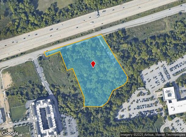
This Property Is For Sale
NEARBY LISTINGS FOR SALE OR LEASE
-
-
View all Malvern listings for sale on LoopNet.com
Property Detail
85 Matthews Rd
Philadelphia-Camden-Wilmington, PA-NJ-DE-MD
Vanguard Plan Prcl
42-005-0001.0100
6.4 AC LOT 1
Commercialacreage
Chester
A
Pennsylvania
42029C0160G
1
2024
6.43 AC
2025
Philadelphia West Suburbs
302103
Philadelphia
DEMOGRAPHICS near 85 Matthews Rd
1 Mile
3 Mile
5 Mile
2024 Total Population
3,261
37,031
86,960
2029 Population
3,482
38,980
90,895
Pop Growth 2024-2029
+ 6.78%
+ 5.26%
+ 4.53%
Average Age
42
42
43
2024 Total Households
1,376
13,962
33,144
HH Growth 2024-2029
+ 6.98%
+ 5.41%
+ 4.66%
Median Household Inc
$114,523
$133,160
$136,529
Avg Household Size
2.30
2.50
2.50
2024 Avg HH Vehicles
2.00
2.00
2.00
Median Home Value
$442,307
$609,808
$593,473
Median Year Built
1981
1979
1979
Nearby Places
- Restaurants
- Banks
- Shops
- Fitness
- Groceries
PUBLIC TRANSPORTATION
AIRPORT
Philadelphia International
DRIVE
WALK
Distance
Philadelphia International
42 min
33.4 mi
Nearby Properties
Address
Land Use
TOTAL SIZE
Lot Size
Zoning
Address
Land Use
TOTAL SIZE
Lot Size
Zoning
887,909 SF
22.50 AC
I
Address
Land Use
TOTAL SIZE
Lot Size
Zoning
691,182 SF
84.22 AC
GI
Address
Land Use
TOTAL SIZE
Lot Size
Zoning
734,062 SF
150.80 AC
R1
Address
Land Use
TOTAL SIZE
Lot Size
Zoning
461,014 SF
70.50 AC
R1
Address
Land Use
TOTAL SIZE
Lot Size
Zoning
1,173,683 SF
56.30 AC
LI
Address
Land Use
TOTAL SIZE
Lot Size
Zoning
615,910 SF
24.84 AC
C1
Address
Land Use
TOTAL SIZE
Lot Size
Zoning
921,976 SF
111 AC
PO1
Address
Land Use
TOTAL SIZE
Lot Size
Zoning
273,175 SF
20.46 AC
PO1
Address
Land Use
TOTAL SIZE
Lot Size
Zoning
447,886 SF
13.17 AC
C1
Address
Land Use
TOTAL SIZE
Lot Size
Zoning
268,392 SF
13.73 AC
RIC
Address
Land Use
TOTAL SIZE
Lot Size
Zoning
213,162 SF
28.54 AC
RA
Address
Land Use
TOTAL SIZE
Lot Size
Zoning
377,378 SF
33.20 AC
LI
Address
Land Use
TOTAL SIZE
Lot Size
Zoning
395,031 SF
17.96 AC
PIP
Address
Land Use
TOTAL SIZE
Lot Size
Zoning
412,888 SF
44.75 AC
LI
Address
Land Use
TOTAL SIZE
Lot Size
Zoning
338,507 SF
2.08 AC
R2
Address
Land Use
TOTAL SIZE
Lot Size
Zoning
351,149 SF
12.73 AC
OA
Address
Land Use
TOTAL SIZE
Lot Size
Zoning
370,879 SF
21.60 AC
R1
Address
Land Use
TOTAL SIZE
Lot Size
Zoning
238,137 SF
6.29 AC
C1
Address
Land Use
TOTAL SIZE
Lot Size
Zoning
129,289 SF
4 AC
R1
Address
Land Use
TOTAL SIZE
Lot Size
Zoning
214,675 SF
22.50 AC
PO2
Address
Land Use
TOTAL SIZE
Lot Size
Zoning
413,028 SF
3.92 AC
C2
Address
Land Use
TOTAL SIZE
Lot Size
Zoning
224,421 SF
97.34 AC
R1
Address
Land Use
TOTAL SIZE
Lot Size
Zoning
154,066 SF
18.10 AC
O
Address
Land Use
TOTAL SIZE
Lot Size
Zoning
124,849 SF
22.09 AC
RIC
Address
Land Use
TOTAL SIZE
Lot Size
Zoning
223,303 SF
15.80 AC
LI
Address
Land Use
TOTAL SIZE
Lot Size
Zoning
474,486 SF
30 AC
R1
Address
Land Use
TOTAL SIZE
Lot Size
Zoning
129,207 SF
13.24 AC
R2
Address
Land Use
TOTAL SIZE
Lot Size
Zoning
264,792 SF
23.50 AC
C3
Address
Land Use
TOTAL SIZE
Lot Size
Zoning
196,076 SF
14.04 AC
LI
Address
Land Use
TOTAL SIZE
Lot Size
Zoning
299,258 SF
11.90 AC
OA
The World's #1 Commercial Real Estate Marketplace
Connect with us
© 2025 CoStar Group
The information above has been obtained from sources believed reliable. While we do not doubt its accuracy we have not verified it and make no guarantee, warranty or representation about it. It is your responsibility to independently confirm its accuracy and completeness. Any projections, opinions, assumptions, or estimates used are for example only and do not represent the current or future performance of the property. The value of this transaction to you depends on tax and other factors which should be evaluated by your tax, financial, and legal advisors. You and your advisors should conduct a careful, independent investigation of the property to determine to your satisfaction the suitability of the property for your needs.