Property Record
45 N Red Trail Ln, Washington, UT 84780
Save to a Folder
{{folder.Name}}
{{folder.ListingIds.length}} Properties
{{folder.ListingIds.length}} Property
Create a New Folder
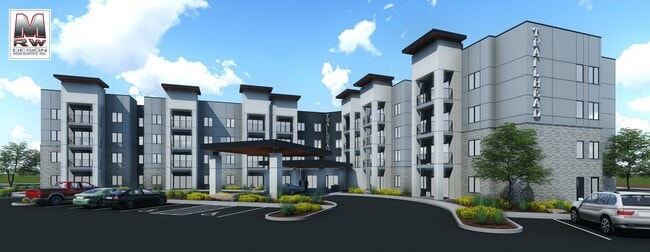
Property Detail
45 N Red Trail Ln
1060983
S: 13 T: 42S R: 15W BEGINNING AT A POINT WHICH IS NORTH 005418 EAST 1823.84 FEET ALONG THE CENTER SECTION LINE FROM THE SOUTH 1/4 CORNER OF SECTION 13, TOWNSHIP 42 SOUTH, RANGE 15 WEST OF THE SALT LAKE BASE AND MERIDIAN AND RUNNING THENCE ALONG SAID
Commercialnec
Washington
B and X Area of moderate flood hazard, usually the area between the limits of the 100-year and 500-year floods.
Utah
2024
5.64 AC
2025
Cedar City & St George
270805
Other Market Areas
99,566 SF
St. George, UT
NEARBY LISTINGS FOR SALE OR LEASE
-
-
View all Washington listings for lease on LoopNet.com
DEMOGRAPHICS near 45 N Red Trail Ln
1 mile
3 mile
5 mile
2025 Total Population
8,175
39,509
64,902
2030 Population
9,215
43,845
71,767
Pop Growth 2025-2030
+ 12.72%
+ 10.97%
+ 10.58%
Average Age
40
40
40
2025 Total Households
2,990
13,823
22,323
HH Growth 2025-2030
+ 13.21%
+ 11.54%
+ 11.00%
Median Household Inc
$64,405
$78,798
$77,290
Avg Household Size
2.70
2.80
2.80
2025 Avg HH Vehicles
2.00
2.00
2.00
Median Home Value
$450,628
$559,941
$571,736
Median Year Built
2007
2007
2006
Nearby Places
Map Layers
Map Styles
 Street
 Aerial
Layers
 Traffic
 Biking
Places
Listings with unknown addresses are not visible on the map
- Restaurants
- Banks
- Shops
- Fitness
- Groceries
PUBLIC TRANSPORTATION
AIRPORT
St George Regional
Drive
Walk
Distance
St George Regional
16 min
8.1 mi
Freight Ports
Port of Long Beach
Drive
Walk
Distance
Port of Long Beach
448 min
407.2 mi
SALE & LEASE HISTORY
LISTING DATE
SALE/LEASE

Apr 06, 2023
For Lease
Nearby Properties
Address
Land Use
TOTAL SIZE
Lot Size
Zoning
Address
Land Use
TOTAL SIZE
Lot Size
Zoning
470 SF
11,422.06 AC
OSC20
Address
Land Use
TOTAL SIZE
Lot Size
Zoning
1,319 SF
549.51 AC
Address
Land Use
TOTAL SIZE
Lot Size
Zoning
230,880 SF
25.58 AC
C-2
Address
Land Use
TOTAL SIZE
Lot Size
Zoning
87,826 SF
37.27 AC
Address
Land Use
TOTAL SIZE
Lot Size
Zoning
97,572 SF
10.51 AC
PD
Address
Land Use
TOTAL SIZE
Lot Size
Zoning
86,875 SF
77.53 AC
Address
Land Use
TOTAL SIZE
Lot Size
Zoning
153,140 SF
17.17 AC
C-3
Address
Land Use
TOTAL SIZE
Lot Size
Zoning
72,862 SF
3.20 AC
Address
Land Use
TOTAL SIZE
Lot Size
Zoning
111,865 SF
5 AC
M-2
Address
Land Use
TOTAL SIZE
Lot Size
Zoning
88,962 SF
8.35 AC
C-3
Address
Land Use
TOTAL SIZE
Lot Size
Zoning
115,050 SF
10.15 AC
C-2
Address
Land Use
TOTAL SIZE
Lot Size
Zoning
52,076 SF
4.81 AC
C-2
Address
Land Use
TOTAL SIZE
Lot Size
Zoning
31,955 SF
5.44 AC
C-2
Address
Land Use
TOTAL SIZE
Lot Size
Zoning
2,903 SF
37.45 AC
A20
Address
Land Use
TOTAL SIZE
Lot Size
Zoning
14,662 SF
31.24 AC
R110
Address
Land Use
TOTAL SIZE
Lot Size
Zoning
35,139 SF
3.85 AC
C-3
Address
Land Use
TOTAL SIZE
Lot Size
Zoning
188,536 SF
5.79 AC
M-2
Address
Land Use
TOTAL SIZE
Lot Size
Zoning
68,697 SF
5.13 AC
Address
Land Use
TOTAL SIZE
Lot Size
Zoning
5,108 SF
19.79 AC
Address
Land Use
TOTAL SIZE
Lot Size
Zoning
35,680 SF
10.33 AC
Address
Land Use
TOTAL SIZE
Lot Size
Zoning
105,742 SF
2.31 AC
C-2
Address
Land Use
TOTAL SIZE
Lot Size
Zoning
25,380 SF
2.09 AC
I
Address
Land Use
TOTAL SIZE
Lot Size
Zoning
103,829 SF
5.88 AC
I
Address
Land Use
TOTAL SIZE
Lot Size
Zoning
8,116 SF
26.26 AC
Address
Land Use
TOTAL SIZE
Lot Size
Zoning
35,122 SF
3.53 AC
Address
Land Use
TOTAL SIZE
Lot Size
Zoning
48,411 SF
4.42 AC
C-3
Address
Land Use
TOTAL SIZE
Lot Size
Zoning
41,922 SF
5.22 AC
Address
Land Use
TOTAL SIZE
Lot Size
Zoning
62,826 SF
2.29 AC
The World's #1 Commercial Real Estate Marketplace
Connect with us
© 2026 CoStar Group
The information above has been obtained from sources believed reliable. While we do not doubt its accuracy we have not verified it and make no guarantee, warranty or representation about it. It is your responsibility to independently confirm its accuracy and completeness. Any projections, opinions, assumptions, or estimates used are for example only and do not represent the current or future performance of the property. The value of this transaction to you depends on tax and other factors which should be evaluated by your tax, financial, and legal advisors. You and your advisors should conduct a careful, independent investigation of the property to determine to your satisfaction the suitability of the property for your needs.