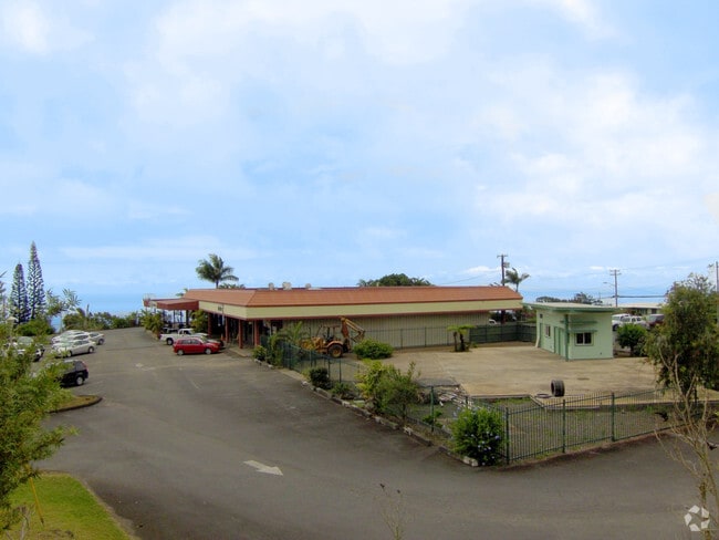
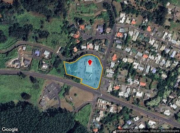
Property Record
45 Pakalana St, Honokaa, HI 96727


NEARBY LISTINGS FOR SALE OR LEASE
-
-
View all Honokaa listings for sale on LoopNet.com
Property Detail
45 Pakalana St
Hilo-Kailua, HI
Honokaa
3-4-5-010-085-0000
LOT A 2.879 AC DES POR RPGR 3163 & 6729 LCAW 9971:5
Commercialnec
Hawaii
X
Hawaii
1551660229F
a
2025
2.88 AC
2025
Hilo/East Big Island
021902
Hawaii
8,624 SF
DEMOGRAPHICS near 45 Pakalana St
1 Mile
3 Mile
5 Mile
2024 Total Population
2,431
6,180
6,521
2029 Population
2,565
6,517
6,875
Pop Growth 2024-2029
+ 5.51%
+ 5.45%
+ 5.43%
Average Age
42
43
43
2024 Total Households
776
2,043
2,154
HH Growth 2024-2029
+ 5.54%
+ 5.43%
+ 5.43%
Median Household Inc
$63,750
$64,600
$64,756
Avg Household Size
3.00
3.00
3.00
2024 Avg HH Vehicles
2.00
2.00
2.00
Median Home Value
$429,737
$496,126
$501,689
Median Year Built
1965
1965
1965
Nearby Places
Map Layers
Map Styles
 Street
 Aerial
- Restaurants
- Banks
- Shops
- Fitness
- Groceries
PUBLIC TRANSPORTATION
AIRPORT
Hilo International
DRIVE
WALK
Distance
Hilo International
78 min
45.2 mi
Nearby Properties
Address
Land Use
TOTAL SIZE
Lot Size
Zoning
Address
Land Use
TOTAL SIZE
Lot Size
Zoning
76,992 SF
9.51 AC
A-40a
Address
Land Use
TOTAL SIZE
Lot Size
Zoning
11,456 SF
16.90 AC
A-40a
Address
Land Use
TOTAL SIZE
Lot Size
Zoning
6,603 SF
5.22 AC
A-40a
Address
Land Use
TOTAL SIZE
Lot Size
Zoning
12.51 AC
A-40a
Address
Land Use
TOTAL SIZE
Lot Size
Zoning
4,454 SF
2.50 AC
A-40a
Address
Land Use
TOTAL SIZE
Lot Size
Zoning
4,777 SF
0.67 AC
A-1a
Address
Land Use
TOTAL SIZE
Lot Size
Zoning
5,873 SF
5.42 AC
A-5a
Address
Land Use
TOTAL SIZE
Lot Size
Zoning
9,328 SF
0.29 AC
CV-10
Address
Land Use
TOTAL SIZE
Lot Size
Zoning
2,378 SF
5 AC
A-5a
Address
Land Use
TOTAL SIZE
Lot Size
Zoning
3,072 SF
5 AC
A-5a
Address
Land Use
TOTAL SIZE
Lot Size
Zoning
14,587 SF
0.53 AC
RS-7.5
Address
Land Use
TOTAL SIZE
Lot Size
Zoning
3,342 SF
18.37 AC
A-5a
Address
Land Use
TOTAL SIZE
Lot Size
Zoning
16,708 SF
2.56 AC
A-40a
Address
Land Use
TOTAL SIZE
Lot Size
Zoning
3,414 SF
7.24 AC
A-5a
Address
Land Use
TOTAL SIZE
Lot Size
Zoning
1,641 SF
8.24 AC
A-40a
Address
Land Use
TOTAL SIZE
Lot Size
Zoning
3,130 SF
7.37 AC
A-5a
Address
Land Use
TOTAL SIZE
Lot Size
Zoning
2,292 SF
6.09 AC
RA-2a
Address
Land Use
TOTAL SIZE
Lot Size
Zoning
2,082 SF
5.23 AC
A-5a
Address
Land Use
TOTAL SIZE
Lot Size
Zoning
9,930 SF
0.59 AC
CV-10
Address
Land Use
TOTAL SIZE
Lot Size
Zoning
2,392 SF
20.09 AC
A-40a
Address
Land Use
TOTAL SIZE
Lot Size
Zoning
972 SF
13.37 AC
A-5a
Address
Land Use
TOTAL SIZE
Lot Size
Zoning
7,557 SF
5 AC
A-5a
Address
Land Use
TOTAL SIZE
Lot Size
Zoning
7,468 SF
1.60 AC
CV-10
Address
Land Use
TOTAL SIZE
Lot Size
Zoning
4,152 SF
2.21 AC
A-5a
Address
Land Use
TOTAL SIZE
Lot Size
Zoning
3,112 SF
1.22 AC
A-5a
Address
Land Use
TOTAL SIZE
Lot Size
Zoning
3,640 SF
2.61 AC
A-5a
Address
Land Use
TOTAL SIZE
Lot Size
Zoning
3,344 SF
5.01 AC
A-5a
Address
Land Use
TOTAL SIZE
Lot Size
Zoning
2,229 SF
5 AC
A-5a
Address
Land Use
TOTAL SIZE
Lot Size
Zoning
2,126 SF
7.83 AC
A-5a
The World's #1 Commercial Real Estate Marketplace
Connect with us
© 2026 CoStar Group
The information above has been obtained from sources believed reliable. While we do not doubt its accuracy we have not verified it and make no guarantee, warranty or representation about it. It is your responsibility to independently confirm its accuracy and completeness. Any projections, opinions, assumptions, or estimates used are for example only and do not represent the current or future performance of the property. The value of this transaction to you depends on tax and other factors which should be evaluated by your tax, financial, and legal advisors. You and your advisors should conduct a careful, independent investigation of the property to determine to your satisfaction the suitability of the property for your needs.