Property Record
45 Voss Pkwy, Boerne, TX 78006


Save to a Folder
{{folder.Name}}
{{folder.ListingIds.length}} Properties
{{folder.ListingIds.length}} Property
Create a New Folder
Property Detail
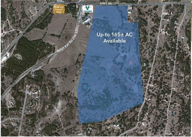
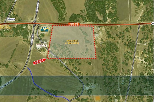
45 Voss Pkwy
12620
A10144 - SURVEY 247 A DODD 33.808 ACRES
Publicschool
KENDALL
B and X Area of moderate flood hazard, usually the area between the limits of the 100-year and 500-year floods.
Texas
0
33.81 AC
2025
Kendall County
970406
San Antonio
1,942 SF
San Antonio-New Braunfels, TX
NEARBY LISTINGS FOR SALE OR LEASE
-
-
View all Boerne listings for sale on LoopNet.com
DEMOGRAPHICS near 45 Voss Pkwy
1 mile
3 mile
5 mile
2025 Total Population
557
3,368
9,580
2030 Population
620
3,785
11,058
Pop Growth 2025-2030
+ 11.31%
+ 12.38%
+ 15.43%
Average Age
45
47
46
2025 Total Households
185
1,208
3,473
HH Growth 2025-2030
+ 11.35%
+ 12.42%
+ 15.49%
Median Household Inc
$178,205
$184,705
$169,544
Avg Household Size
2.90
2.70
2.70
2025 Avg HH Vehicles
3.00
3.00
3.00
Median Home Value
$799,342
$931,133
$787,510
Median Year Built
1999
2005
2007
Nearby Places
Map Layers
Map Styles
 Street
 Aerial
Layers
 Traffic
 Biking
Places
Listings with unknown addresses are not visible on the map
- Restaurants
- Banks
- Shops
- Fitness
- Groceries
PUBLIC TRANSPORTATION
AIRPORT
San Antonio International
Drive
Walk
Distance
San Antonio International
42 min
31.0 mi
Freight Ports
Calhoun Port
Drive
Walk
Distance
Calhoun Port
220 min
176.9 mi
Nearby Properties
Address
Land Use
TOTAL SIZE
Lot Size
Zoning
Address
Land Use
TOTAL SIZE
Lot Size
Zoning
157,537 SF
83.94 AC
Address
Land Use
TOTAL SIZE
Lot Size
Zoning
43,173 SF
91.99 AC
Address
Land Use
TOTAL SIZE
Lot Size
Zoning
46,506 SF
11.40 AC
Address
Land Use
TOTAL SIZE
Lot Size
Zoning
47,002 SF
6.01 AC
Address
Land Use
TOTAL SIZE
Lot Size
Zoning
13,041 SF
10.44 AC
Address
Land Use
TOTAL SIZE
Lot Size
Zoning
11,187 SF
43.23 AC
Address
Land Use
TOTAL SIZE
Lot Size
Zoning
47,590 SF
5.80 AC
Address
Land Use
TOTAL SIZE
Lot Size
Zoning
18,338 SF
4.50 AC
Address
Land Use
TOTAL SIZE
Lot Size
Zoning
11,460 SF
3.01 AC
Address
Land Use
TOTAL SIZE
Lot Size
Zoning
12,075 SF
17.04 AC
Address
Land Use
TOTAL SIZE
Lot Size
Zoning
32.21 AC
Address
Land Use
TOTAL SIZE
Lot Size
Zoning
13,864 SF
4.81 AC
Address
Land Use
TOTAL SIZE
Lot Size
Zoning
12,128 SF
3.88 AC
Address
Land Use
TOTAL SIZE
Lot Size
Zoning
6,000 SF
3 AC
Address
Land Use
TOTAL SIZE
Lot Size
Zoning
9,076 SF
2.94 AC
Address
Land Use
TOTAL SIZE
Lot Size
Zoning
7,165 SF
23.34 AC
Address
Land Use
TOTAL SIZE
Lot Size
Zoning
5,462 SF
1.20 AC
Address
Land Use
TOTAL SIZE
Lot Size
Zoning
30,285 SF
3.23 AC
Address
Land Use
TOTAL SIZE
Lot Size
Zoning
7,278 SF
3.79 AC
Address
Land Use
TOTAL SIZE
Lot Size
Zoning
7,950 SF
74.80 AC
Address
Land Use
TOTAL SIZE
Lot Size
Zoning
3,370 SF
4.74 AC
Address
Land Use
TOTAL SIZE
Lot Size
Zoning
1,902 SF
5.70 AC
Address
Land Use
TOTAL SIZE
Lot Size
Zoning
5.18 AC
Address
Land Use
TOTAL SIZE
Lot Size
Zoning
12.06 AC
Address
Land Use
TOTAL SIZE
Lot Size
Zoning
6,750 SF
2.64 AC
Address
Land Use
TOTAL SIZE
Lot Size
Zoning
3.09 AC
Address
Land Use
TOTAL SIZE
Lot Size
Zoning
61.49 AC
Address
Land Use
TOTAL SIZE
Lot Size
Zoning
1.62 AC
Address
Land Use
TOTAL SIZE
Lot Size
Zoning
2,916 SF
29.19 AC
The World's #1 Commercial Real Estate Marketplace
Connect with us
© 2026 CoStar Group
The information above has been obtained from sources believed reliable. While we do not doubt its accuracy we have not verified it and make no guarantee, warranty or representation about it. It is your responsibility to independently confirm its accuracy and completeness. Any projections, opinions, assumptions, or estimates used are for example only and do not represent the current or future performance of the property. The value of this transaction to you depends on tax and other factors which should be evaluated by your tax, financial, and legal advisors. You and your advisors should conduct a careful, independent investigation of the property to determine to your satisfaction the suitability of the property for your needs.