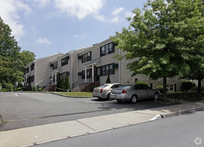
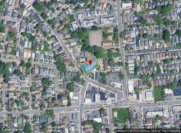
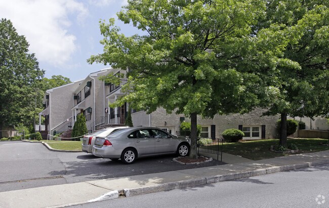
Property Record
45 Watchogue Rd, Staten Island, NY 10314
NEARBY LISTINGS FOR SALE OR LEASE
Property Detail
45 Watchogue Rd
00457-0024
Staten Island
Multifamilydwelling
New York
X
24
3604970307F
0.37 AC
2024
Westerleigh
2025
Long Island (New York)
018902
New York-Jersey City-White Plains, NY-NJ
9,960 SF
DEMOGRAPHICS near 45 Watchogue Rd
1 Mile
3 Mile
5 Mile
2024 Total Population
42,610
269,477
503,820
2029 Population
41,951
264,548
493,540
Pop Growth 2024-2029
(1.55%)
(1.83%)
(2.04%)
Average Age
41
40
40
2024 Total Households
14,611
92,821
177,358
HH Growth 2024-2029
(1.59%)
(1.89%)
(2.14%)
Median Household Inc
$100,397
$84,503
$79,503
Avg Household Size
2.80
2.80
2.70
2024 Avg HH Vehicles
2.00
1.00
1.00
Median Home Value
$681,955
$617,968
$605,166
Median Year Built
1963
1967
1968
Nearby Places
- Restaurants
- Banks
- Shops
- Fitness
- Groceries
PUBLIC TRANSPORTATION
COMMUTER RAIL
Dongan Hills (Staten Island Railway - New York MTA Subway (The Subway))
DRIVE
WALK
Distance
Dongan Hills (Staten Island Railway - New York MTA Subway (The Subway))
10 min
3.4 mi
Jefferson Avenue (Staten Island Railway - New York MTA Subway (The Subway))
DRIVE
WALK
Distance
Jefferson Avenue (Staten Island Railway - New York MTA Subway (The Subway))
10 min
3.6 mi
AIRPORT
Newark Liberty International
DRIVE
WALK
Distance
Newark Liberty International
20 min
12.2 mi
LaGuardia
DRIVE
WALK
Distance
LaGuardia
39 min
23.3 mi
John F Kennedy International
DRIVE
WALK
Distance
John F Kennedy International
38 min
26.0 mi
Freight Ports
New York Container Terminal
DRIVE
WALK
Distance
New York Container Terminal
7 min
4.1 mi
Nearby Properties
Address
Land Use
TOTAL SIZE
Lot Size
Zoning
Address
Land Use
TOTAL SIZE
Lot Size
Zoning
3,600 SF
731.18 AC
PARK
Address
Land Use
TOTAL SIZE
Lot Size
Zoning
633,280 SF
202.90 AC
R3-2
Address
Land Use
TOTAL SIZE
Lot Size
Zoning
22.49 AC
HC
Address
Land Use
TOTAL SIZE
Lot Size
Zoning
686,130 SF
189.62 AC
R3-2
Address
Land Use
TOTAL SIZE
Lot Size
Zoning
1,258,042 SF
14.47 AC
C4-1
Address
Land Use
TOTAL SIZE
Lot Size
Zoning
566,000 SF
103.31 AC
R3-2
Address
Land Use
TOTAL SIZE
Lot Size
Zoning
855,000 SF
48.74 AC
M3-1
Address
Land Use
TOTAL SIZE
Lot Size
Zoning
1,502 SF
0.69 AC
C-1
Address
Land Use
TOTAL SIZE
Lot Size
Zoning
131.25 AC
PARK
Address
Land Use
TOTAL SIZE
Lot Size
Zoning
538,240 SF
12.08 AC
R2
Address
Land Use
TOTAL SIZE
Lot Size
Zoning
494,840 SF
34.77 AC
R3-2
Address
Land Use
TOTAL SIZE
Lot Size
Zoning
970,000 SF
55.25 AC
M3-1
Address
Land Use
TOTAL SIZE
Lot Size
Zoning
195,395 SF
12.04 AC
R3-2
Address
Land Use
TOTAL SIZE
Lot Size
Zoning
521,405 SF
52.79 AC
R3-1
Address
Land Use
TOTAL SIZE
Lot Size
Zoning
975,000 SF
58.52 AC
M3-1
Address
Land Use
TOTAL SIZE
Lot Size
Zoning
418,012 SF
6.74 AC
R3-1
Address
Land Use
TOTAL SIZE
Lot Size
Zoning
111,000 SF
186.03 AC
PARK
Address
Land Use
TOTAL SIZE
Lot Size
Zoning
450,000 SF
33.26 AC
M3-1
Address
Land Use
TOTAL SIZE
Lot Size
Zoning
183,839 SF
9.74 AC
PARK
Address
Land Use
TOTAL SIZE
Lot Size
Zoning
3,179 SF
0.13 AC
Address
Land Use
TOTAL SIZE
Lot Size
Zoning
Address
Land Use
TOTAL SIZE
Lot Size
Zoning
240 SF
47.41 AC
R3-2
Address
Land Use
TOTAL SIZE
Lot Size
Zoning
66.37 AC
PARK
Address
Land Use
TOTAL SIZE
Lot Size
Zoning
328,319 SF
8.58 AC
M1-1
Address
Land Use
TOTAL SIZE
Lot Size
Zoning
48,500 SF
61.98 AC
R3-2
Address
Land Use
TOTAL SIZE
Lot Size
Zoning
74,000 SF
523.69 AC
R3-2
Address
Land Use
TOTAL SIZE
Lot Size
Zoning
84,160 SF
81.12 AC
M1-1
Address
Land Use
TOTAL SIZE
Lot Size
Zoning
226,590 SF
5.52 AC
R3-2
Address
Land Use
TOTAL SIZE
Lot Size
Zoning
146,855 SF
16.50 AC
R3-1
Address
Land Use
TOTAL SIZE
Lot Size
Zoning
The World's #1 Commercial Real Estate Marketplace
Connect with us
© 2025 CoStar Group
The information above has been obtained from sources believed reliable. While we do not doubt its accuracy we have not verified it and make no guarantee, warranty or representation about it. It is your responsibility to independently confirm its accuracy and completeness. Any projections, opinions, assumptions, or estimates used are for example only and do not represent the current or future performance of the property. The value of this transaction to you depends on tax and other factors which should be evaluated by your tax, financial, and legal advisors. You and your advisors should conduct a careful, independent investigation of the property to determine to your satisfaction the suitability of the property for your needs.