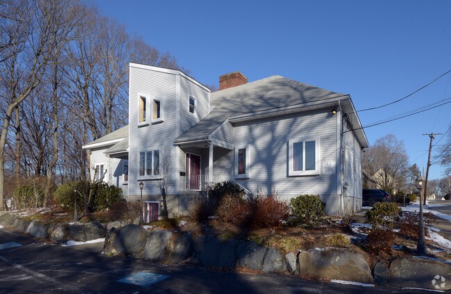
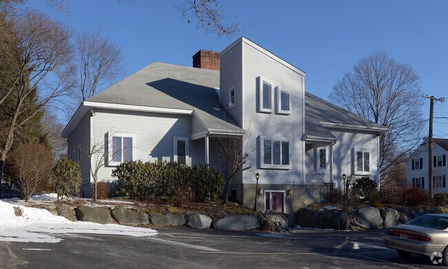
Property Record
45 West St, Attleboro, MA 02703

Save to a Folder
{{folder.Name}}
{{folder.ListingIds.length}} Properties
{{folder.ListingIds.length}} Property
Create a New Folder
Property Detail
45 West St
ATTL-000049-000000-000091
Bristol
Officebuilding
Massachusetts
SRB
91
B and X Area of moderate flood hazard, usually the area between the limits of the 100-year and 500-year floods.
0.54 AC
2025
Attleboro/New Bedford
2025
Boston
631300
Providence-Warwick, RI-MA
5,777 SF
NEARBY LISTINGS FOR SALE OR LEASE
DEMOGRAPHICS near 45 West St
1 mile
3 mile
5 mile
2025 Total Population
9,120
51,743
104,978
2030 Population
9,272
52,855
107,163
Pop Growth 2025-2030
+ 1.67%
+ 2.15%
+ 2.08%
Average Age
41
41
42
2025 Total Households
3,792
20,669
40,796
HH Growth 2025-2030
+ 1.58%
+ 2.20%
+ 2.12%
Median Household Inc
$82,158
$94,424
$102,695
Avg Household Size
2.30
2.40
2.50
2025 Avg HH Vehicles
2.00
2.00
2.00
Median Home Value
$495,642
$480,072
$489,065
Median Year Built
1965
1971
1975
Nearby Places
Map Layers
Map Styles
 Street
 Aerial
Layers
 Traffic
 Biking
Places
Listings with unknown addresses are not visible on the map
- Restaurants
- Banks
- Shops
- Fitness
- Groceries
PUBLIC TRANSPORTATION
COMMUTER RAIL
Drive
Walk
Distance
3 min
1.2 mi
Drive
Walk
Distance
4 min
1.3 mi
AIRPORT
Rhode Island Tf Green International
Drive
Walk
Distance
Rhode Island Tf Green International
36 min
21.3 mi
General Edward Lawrence Logan International
Drive
Walk
Distance
General Edward Lawrence Logan International
56 min
40.3 mi
Nearby Properties
Address
Land Use
TOTAL SIZE
Lot Size
Zoning
Address
Land Use
TOTAL SIZE
Lot Size
Zoning
65.21 AC
Address
Land Use
TOTAL SIZE
Lot Size
Zoning
741,896 SF
27.75 AC
GU
Address
Land Use
TOTAL SIZE
Lot Size
Zoning
98,369 SF
5.53 AC
IC30
Address
Land Use
TOTAL SIZE
Lot Size
Zoning
64.31 AC
C60
Address
Land Use
TOTAL SIZE
Lot Size
Zoning
10.40 AC
Address
Land Use
TOTAL SIZE
Lot Size
Zoning
17,782 SF
25.60 AC
Address
Land Use
TOTAL SIZE
Lot Size
Zoning
Address
Land Use
TOTAL SIZE
Lot Size
Zoning
228,377 SF
24.19 AC
IND
Address
Land Use
TOTAL SIZE
Lot Size
Zoning
228,377 SF
24.19 AC
IND
Address
Land Use
TOTAL SIZE
Lot Size
Zoning
8,432 SF
46 AC
Address
Land Use
TOTAL SIZE
Lot Size
Zoning
5,059 SF
217.41 AC
Address
Land Use
TOTAL SIZE
Lot Size
Zoning
146,400 SF
1.50 AC
CB
Address
Land Use
TOTAL SIZE
Lot Size
Zoning
11,110 SF
25.74 AC
Address
Land Use
TOTAL SIZE
Lot Size
Zoning
110,362 SF
16.70 AC
Address
Land Use
TOTAL SIZE
Lot Size
Zoning
112,766 SF
31.06 AC
Address
Land Use
TOTAL SIZE
Lot Size
Zoning
105,878 SF
12.05 AC
C60
Address
Land Use
TOTAL SIZE
Lot Size
Zoning
70,663 SF
8.80 AC
Address
Land Use
TOTAL SIZE
Lot Size
Zoning
8.29 AC
R10
Address
Land Use
TOTAL SIZE
Lot Size
Zoning
16.82 AC
C60
Address
Land Use
TOTAL SIZE
Lot Size
Zoning
9.52 AC
C7.5
Address
Land Use
TOTAL SIZE
Lot Size
Zoning
76,785 SF
1.17 AC
GB
Address
Land Use
TOTAL SIZE
Lot Size
Zoning
164,001 SF
22.80 AC
Address
Land Use
TOTAL SIZE
Lot Size
Zoning
90,812 SF
12.39 AC
Address
Land Use
TOTAL SIZE
Lot Size
Zoning
12,958 SF
5.50 AC
Address
Land Use
TOTAL SIZE
Lot Size
Zoning
89,242 SF
14.65 AC
C60
Address
Land Use
TOTAL SIZE
Lot Size
Zoning
17,797 SF
79.97 AC
Address
Land Use
TOTAL SIZE
Lot Size
Zoning
91,126 SF
9.71 AC
I60
Address
Land Use
TOTAL SIZE
Lot Size
Zoning
108,382 SF
20.80 AC
Address
Land Use
TOTAL SIZE
Lot Size
Zoning
36,424 SF
1.18 AC
IC3
Address
Land Use
TOTAL SIZE
Lot Size
Zoning
53,375 SF
10.14 AC
IC30
The World's #1 Commercial Real Estate Marketplace
Connect with us
© 2026 CoStar Group
The information above has been obtained from sources believed reliable. While we do not doubt its accuracy we have not verified it and make no guarantee, warranty or representation about it. It is your responsibility to independently confirm its accuracy and completeness. Any projections, opinions, assumptions, or estimates used are for example only and do not represent the current or future performance of the property. The value of this transaction to you depends on tax and other factors which should be evaluated by your tax, financial, and legal advisors. You and your advisors should conduct a careful, independent investigation of the property to determine to your satisfaction the suitability of the property for your needs.