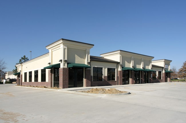
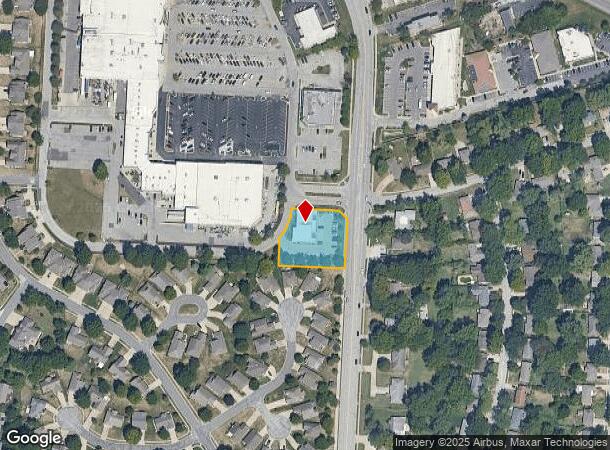
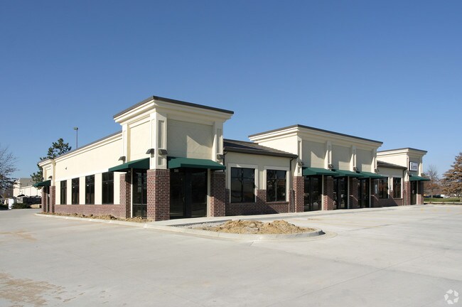
Property Record
450 Sw Ward Rd, Lees Summit, MO 64081

Current Lease Availabilities
NEARBY LISTINGS FOR SALE OR LEASE
Property Detail
450 Sw Ward Rd
Kansas City, MO-KS
Fpc Place Lot 1
62-610-02-77-00-0-00-000
FPC PLACE LOT 1---LOT 1
Regionalshoppingcenterormallwithanchorstore
Jackson
X
Missouri
29095C0417G
1
2024
0.77 AC
2025
Southeast Jackson County
013708
Kansas City
6,124 SF
DEMOGRAPHICS near 450 Sw Ward Rd
1 Mile
3 Mile
5 Mile
2024 Total Population
8,513
51,073
89,361
2029 Population
8,399
50,921
89,060
Pop Growth 2024-2029
(1.34%)
(0.30%)
(0.34%)
Average Age
43
40
40
2024 Total Households
3,737
20,664
34,066
HH Growth 2024-2029
(1.31%)
(0.31%)
(0.37%)
Median Household Inc
$70,573
$87,440
$99,221
Avg Household Size
2.20
2.40
2.60
2024 Avg HH Vehicles
2.00
2.00
2.00
Median Home Value
$228,543
$264,439
$278,851
Median Year Built
1974
1988
1991
Nearby Places
- Restaurants
- Banks
- Shops
- Fitness
- Groceries
PUBLIC TRANSPORTATION
COMMUTER RAIL
Lee's Summit Amtrak (Lincoln Service Missouri River Runner - Amtrak, Missouri River Runner - Amtrak)
DRIVE
WALK
Distance
Lee's Summit Amtrak (Lincoln Service Missouri River Runner - Amtrak, Missouri River Runner - Amtrak)
4 min
1.4 mi
Freight Ports
Tulsa Port Of Catoosa
DRIVE
WALK
Distance
Tulsa Port Of Catoosa
261 min
238.1 mi
Nearby Properties
Address
Land Use
TOTAL SIZE
Lot Size
Zoning
Address
Land Use
TOTAL SIZE
Lot Size
Zoning
474,121 SF
40.14 AC
Address
Land Use
TOTAL SIZE
Lot Size
Zoning
535,500 SF
54.13 AC
Address
Land Use
TOTAL SIZE
Lot Size
Zoning
480,000 SF
45.89 AC
Address
Land Use
TOTAL SIZE
Lot Size
Zoning
246,379 SF
51.99 AC
Address
Land Use
TOTAL SIZE
Lot Size
Zoning
438,125 SF
Address
Land Use
TOTAL SIZE
Lot Size
Zoning
107,210 SF
17.13 AC
Address
Land Use
TOTAL SIZE
Lot Size
Zoning
249,821 SF
87.90 AC
Address
Land Use
TOTAL SIZE
Lot Size
Zoning
246,384 SF
22 AC
Address
Land Use
TOTAL SIZE
Lot Size
Zoning
209,098 SF
Address
Land Use
TOTAL SIZE
Lot Size
Zoning
339,970 SF
Address
Land Use
TOTAL SIZE
Lot Size
Zoning
120,533 SF
12.70 AC
Address
Land Use
TOTAL SIZE
Lot Size
Zoning
52,030 SF
11.81 AC
Address
Land Use
TOTAL SIZE
Lot Size
Zoning
227,052 SF
12.78 AC
Address
Land Use
TOTAL SIZE
Lot Size
Zoning
139,544 SF
21.34 AC
Address
Land Use
TOTAL SIZE
Lot Size
Zoning
100,573 SF
2.89 AC
Address
Land Use
TOTAL SIZE
Lot Size
Zoning
104,368 SF
13.90 AC
Address
Land Use
TOTAL SIZE
Lot Size
Zoning
248,600 SF
Address
Land Use
TOTAL SIZE
Lot Size
Zoning
383,280 SF
0.91 AC
Address
Land Use
TOTAL SIZE
Lot Size
Zoning
563,000 SF
40.34 AC
Address
Land Use
TOTAL SIZE
Lot Size
Zoning
165,827 SF
14.49 AC
Address
Land Use
TOTAL SIZE
Lot Size
Zoning
72,168 SF
Address
Land Use
TOTAL SIZE
Lot Size
Zoning
195,586 SF
20.91 AC
Address
Land Use
TOTAL SIZE
Lot Size
Zoning
184,445 SF
Address
Land Use
TOTAL SIZE
Lot Size
Zoning
136,224 SF
15.25 AC
Address
Land Use
TOTAL SIZE
Lot Size
Zoning
104,704 SF
11.28 AC
Address
Land Use
TOTAL SIZE
Lot Size
Zoning
126,081 SF
21 AC
Address
Land Use
TOTAL SIZE
Lot Size
Zoning
192,014 SF
20.95 AC
Address
Land Use
TOTAL SIZE
Lot Size
Zoning
82,704 SF
148.69 AC
Address
Land Use
TOTAL SIZE
Lot Size
Zoning
125,609 SF
9.32 AC
Address
Land Use
TOTAL SIZE
Lot Size
Zoning
59,820 SF
6.22 AC
The World's #1 Commercial Real Estate Marketplace
Connect with us
© 2025 CoStar Group
The information above has been obtained from sources believed reliable. While we do not doubt its accuracy we have not verified it and make no guarantee, warranty or representation about it. It is your responsibility to independently confirm its accuracy and completeness. Any projections, opinions, assumptions, or estimates used are for example only and do not represent the current or future performance of the property. The value of this transaction to you depends on tax and other factors which should be evaluated by your tax, financial, and legal advisors. You and your advisors should conduct a careful, independent investigation of the property to determine to your satisfaction the suitability of the property for your needs.