Property Record
450 7Th St, Somers Point, NJ 08244

Save to a Folder
{{folder.Name}}
{{folder.ListingIds.length}} Properties
{{folder.ListingIds.length}} Property
Create a New Folder
Property Detail
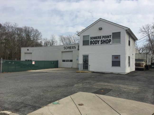
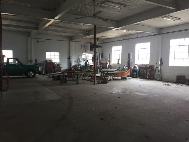
450 7Th St
Atlantic City-Hammonton, NJ
ADDITIONAL LOTS: 45% RESI:55% COMM
21-01016-0000-00013
Atlantic
Vacantlandnec
New Jersey
HC-1
13
2025
0.74 AC
2026
Atlantic City/Hammonton
012801
Philadelphia
10,490 SF
NEARBY LISTINGS FOR SALE OR LEASE
DEMOGRAPHICS near 450 7Th St
1 mile
3 mile
5 mile
2025 Total Population
9,819
23,753
67,879
2030 Population
9,861
23,807
69,726
Pop Growth 2025-2030
+ 0.43%
+ 0.23%
+ 2.72%
Average Age
44
44
45
2025 Total Households
4,359
9,662
28,084
HH Growth 2025-2030
(0.16%)
(0.37%)
+ 2.90%
Median Household Inc
$70,507
$93,451
$100,072
Avg Household Size
2.20
2.40
2.30
2025 Avg HH Vehicles
2.00
2.00
2.00
Median Home Value
$289,737
$338,281
$392,749
Median Year Built
1968
1971
1976
Nearby Places
Map Layers
Map Styles
 Street
 Aerial
Layers
 Traffic
 Biking
Places
Listings with unknown addresses are not visible on the map
- Restaurants
- Banks
- Shops
- Fitness
- Groceries
PUBLIC TRANSPORTATION
COMMUTER RAIL
Absecon (Atlantic City Line - NJ Transit Commuter Rail (NJ Transit))
Drive
Walk
Distance
Absecon (Atlantic City Line - NJ Transit Commuter Rail (NJ Transit))
18 min
9.5 mi
AIRPORT
Atlantic City International
Drive
Walk
Distance
Atlantic City International
42 min
15.7 mi
Freight Ports
Broadway Terminal - Pier 5
Drive
Walk
Distance
Broadway Terminal - Pier 5
73 min
57.6 mi
SALE & LEASE HISTORY
LISTING DATE
SALE/LEASE

Mar 10, 2017
For Sale
Jun 21, 2020
For Lease
Nearby Properties
Address
Land Use
TOTAL SIZE
Lot Size
Zoning
Address
Land Use
TOTAL SIZE
Lot Size
Zoning
4.98 AC
SHOS
Address
Land Use
TOTAL SIZE
Lot Size
Zoning
6,000 SF
28.83 AC
INST
Address
Land Use
TOTAL SIZE
Lot Size
Zoning
51.72 AC
GB &
Address
Land Use
TOTAL SIZE
Lot Size
Zoning
16.33 AC
R-MF
Address
Land Use
TOTAL SIZE
Lot Size
Zoning
17.37 AC
REDE
Address
Land Use
TOTAL SIZE
Lot Size
Zoning
15.20 AC
R-MF
Address
Land Use
TOTAL SIZE
Lot Size
Zoning
3.34 AC
R-1
Address
Land Use
TOTAL SIZE
Lot Size
Zoning
6.75 AC
R-1
Address
Land Use
TOTAL SIZE
Lot Size
Zoning
2.21 AC
SHOS
Address
Land Use
TOTAL SIZE
Lot Size
Zoning
8.41 AC
R-MF
Address
Land Use
TOTAL SIZE
Lot Size
Zoning
9.20 AC
GB
Address
Land Use
TOTAL SIZE
Lot Size
Zoning
4.81 AC
R-MF
Address
Land Use
TOTAL SIZE
Lot Size
Zoning
8.56 AC
R-MF
Address
Land Use
TOTAL SIZE
Lot Size
Zoning
5.02 AC
R-MF
Address
Land Use
TOTAL SIZE
Lot Size
Zoning
4.74 AC
INST
Address
Land Use
TOTAL SIZE
Lot Size
Zoning
2,680 SF
2.32 AC
INST
Address
Land Use
TOTAL SIZE
Lot Size
Zoning
61,193 SF
6.97 AC
GB
Address
Land Use
TOTAL SIZE
Lot Size
Zoning
4.43 AC
R-MF
Address
Land Use
TOTAL SIZE
Lot Size
Zoning
4.42 AC
TC&F
Address
Land Use
TOTAL SIZE
Lot Size
Zoning
2.98 AC
R-1
Address
Land Use
TOTAL SIZE
Lot Size
Zoning
8.73 AC
RECA
Address
Land Use
TOTAL SIZE
Lot Size
Zoning
11 AC
BUS
Address
Land Use
TOTAL SIZE
Lot Size
Zoning
6.43 AC
GB
Address
Land Use
TOTAL SIZE
Lot Size
Zoning
52,280 SF
9.96 AC
GB
Address
Land Use
TOTAL SIZE
Lot Size
Zoning
1.21 AC
SHOS
Address
Land Use
TOTAL SIZE
Lot Size
Zoning
38,090 SF
4.73 AC
O-PB
Address
Land Use
TOTAL SIZE
Lot Size
Zoning
14.01 AC
INST
Address
Land Use
TOTAL SIZE
Lot Size
Zoning
1.35 AC
MVH
Address
Land Use
TOTAL SIZE
Lot Size
Zoning
107,676 SF
3.70 AC
R-MF
Address
Land Use
TOTAL SIZE
Lot Size
Zoning
1.32 AC
The World's #1 Commercial Real Estate Marketplace
Connect with us
© 2026 CoStar Group
The information above has been obtained from sources believed reliable. While we do not doubt its accuracy we have not verified it and make no guarantee, warranty or representation about it. It is your responsibility to independently confirm its accuracy and completeness. Any projections, opinions, assumptions, or estimates used are for example only and do not represent the current or future performance of the property. The value of this transaction to you depends on tax and other factors which should be evaluated by your tax, financial, and legal advisors. You and your advisors should conduct a careful, independent investigation of the property to determine to your satisfaction the suitability of the property for your needs.