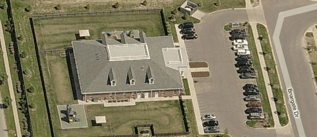
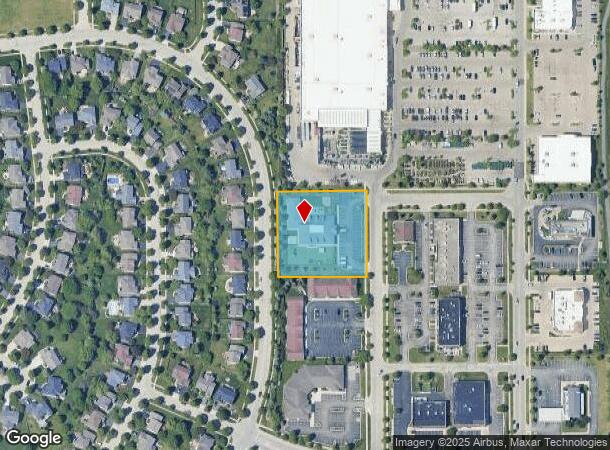
Property Record
450 Briargate Dr, South Elgin, IL 60177
NEARBY LISTINGS FOR SALE OR LEASE
Property Detail
450 Briargate Dr
Chicago-Naperville-Elgin, IL-IN-WI
Thornwood Center
09-05-254-002
THORNWOOD CENTER LOT 3
Commercialnec
Kane
X
Illinois
17089C0251H
3
2024
1.48 AC
2024
Western East/West Corr
852101
Chicago
8,187 SF
DEMOGRAPHICS near 450 Briargate Dr
1 Mile
3 Mile
5 Mile
2024 Total Population
7,644
45,016
121,630
2029 Population
7,535
44,231
120,077
Pop Growth 2024-2029
(1.43%)
(1.74%)
(1.28%)
Average Age
38
40
40
2024 Total Households
2,468
15,804
42,102
HH Growth 2024-2029
(1.46%)
(1.76%)
(1.32%)
Median Household Inc
$152,717
$117,984
$109,407
Avg Household Size
3.10
2.80
2.80
2024 Avg HH Vehicles
2.00
2.00
2.00
Median Home Value
$391,766
$303,573
$312,005
Median Year Built
2002
1996
1990
Nearby Places
Map Layers
Map Styles
 Street
 Aerial
- Restaurants
- Banks
- Shops
- Fitness
- Groceries
PUBLIC TRANSPORTATION
COMMUTER RAIL
National Street Station (Milwaukee District West Line - Northeast Illinois Regional Commuter Railroad (Metra))
DRIVE
WALK
Distance
National Street Station (Milwaukee District West Line - Northeast Illinois Regional Commuter Railroad (Metra))
13 min
6.6 mi
Elgin Station (Milwaukee District West Line - Northeast Illinois Regional Commuter Railroad (Metra))
DRIVE
WALK
Distance
Elgin Station (Milwaukee District West Line - Northeast Illinois Regional Commuter Railroad (Metra))
12 min
6.8 mi
AIRPORT
Chicago O'Hare International
DRIVE
WALK
Distance
Chicago O'Hare International
46 min
35.5 mi
Freight Ports
Port Milwaukee
DRIVE
WALK
Distance
Port Milwaukee
125 min
91.9 mi
Nearby Properties
Address
Land Use
TOTAL SIZE
Lot Size
Zoning
Address
Land Use
TOTAL SIZE
Lot Size
Zoning
15.31 AC
Address
Land Use
TOTAL SIZE
Lot Size
Zoning
Address
Land Use
TOTAL SIZE
Lot Size
Zoning
4.08 AC
Address
Land Use
TOTAL SIZE
Lot Size
Zoning
5,596 SF
15.30 AC
Address
Land Use
TOTAL SIZE
Lot Size
Zoning
186,692 SF
19.48 AC
Address
Land Use
TOTAL SIZE
Lot Size
Zoning
30,000 SF
9.96 AC
Address
Land Use
TOTAL SIZE
Lot Size
Zoning
Address
Land Use
TOTAL SIZE
Lot Size
Zoning
5.44 AC
Address
Land Use
TOTAL SIZE
Lot Size
Zoning
175,152 SF
14.30 AC
Address
Land Use
TOTAL SIZE
Lot Size
Zoning
103,536 SF
17.71 AC
Address
Land Use
TOTAL SIZE
Lot Size
Zoning
134,434 SF
8.83 AC
Address
Land Use
TOTAL SIZE
Lot Size
Zoning
106,421 SF
10.76 AC
Address
Land Use
TOTAL SIZE
Lot Size
Zoning
160,680 SF
13.71 AC
Address
Land Use
TOTAL SIZE
Lot Size
Zoning
17,680 SF
5.63 AC
Address
Land Use
TOTAL SIZE
Lot Size
Zoning
104,510 SF
9.54 AC
Address
Land Use
TOTAL SIZE
Lot Size
Zoning
7.83 AC
Address
Land Use
TOTAL SIZE
Lot Size
Zoning
Address
Land Use
TOTAL SIZE
Lot Size
Zoning
55,905 SF
5.36 AC
Address
Land Use
TOTAL SIZE
Lot Size
Zoning
7,632 SF
94.93 AC
Address
Land Use
TOTAL SIZE
Lot Size
Zoning
136,280 SF
9.18 AC
Address
Land Use
TOTAL SIZE
Lot Size
Zoning
137,927 SF
4.40 AC
Address
Land Use
TOTAL SIZE
Lot Size
Zoning
15,400 SF
1.47 AC
Address
Land Use
TOTAL SIZE
Lot Size
Zoning
3.15 AC
Address
Land Use
TOTAL SIZE
Lot Size
Zoning
21,147 SF
2.67 AC
Address
Land Use
TOTAL SIZE
Lot Size
Zoning
22.23 AC
Address
Land Use
TOTAL SIZE
Lot Size
Zoning
85,520 SF
8.56 AC
Address
Land Use
TOTAL SIZE
Lot Size
Zoning
31,944 SF
2.91 AC
Address
Land Use
TOTAL SIZE
Lot Size
Zoning
44,310 SF
4.77 AC
Address
Land Use
TOTAL SIZE
Lot Size
Zoning
Address
Land Use
TOTAL SIZE
Lot Size
Zoning
65,060 SF
2.54 AC
The World's #1 Commercial Real Estate Marketplace
Connect with us
© 2025 CoStar Group
The information above has been obtained from sources believed reliable. While we do not doubt its accuracy we have not verified it and make no guarantee, warranty or representation about it. It is your responsibility to independently confirm its accuracy and completeness. Any projections, opinions, assumptions, or estimates used are for example only and do not represent the current or future performance of the property. The value of this transaction to you depends on tax and other factors which should be evaluated by your tax, financial, and legal advisors. You and your advisors should conduct a careful, independent investigation of the property to determine to your satisfaction the suitability of the property for your needs.