Property Record
450 Garrisonville Rd, Stafford, VA 22554
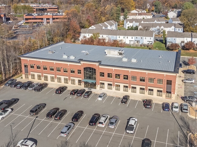

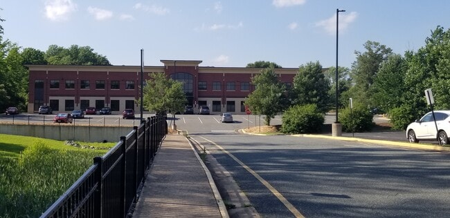

This Property Is For Sale
NEARBY LISTINGS FOR SALE OR LEASE
Property Detail
450 Garrisonville Rd
Washington, DC
Garrisonville Office Condo Lr250008988
Washington-Arlington-Alexandria, DC-VA-MD-WV
UNIT 205 CONVERTIBLE SPACE 0.0433 AC GARRISONVILLE OFFICE CONDO LR250008988
20ZZ-205
Stafford
Officecondo
Virginia
0
0.04 AC
2025
Stafford County
010206
DEMOGRAPHICS near 450 Garrisonville Rd
1 Mile
3 Mile
5 Mile
2024 Total Population
11,338
54,241
88,735
2029 Population
12,592
60,298
98,437
Pop Growth 2024-2029
+ 11.06%
+ 11.17%
+ 10.93%
Average Age
35
35
35
2024 Total Households
3,597
16,911
27,087
HH Growth 2024-2029
+ 11.09%
+ 11.17%
+ 11.18%
Median Household Inc
$99,572
$120,865
$123,651
Avg Household Size
3.10
3.10
3.10
2024 Avg HH Vehicles
2.00
2.00
2.00
Median Home Value
$350,536
$391,456
$398,107
Median Year Built
1993
1996
1996
Nearby Places
Map Layers
Map Styles
 Street
 Aerial
- Restaurants
- Banks
- Shops
- Fitness
- Groceries
PUBLIC TRANSPORTATION
COMMUTER RAIL
Brooke (Fredericksburg Line - Virginia Railway Express)
DRIVE
WALK
Distance
Brooke (Fredericksburg Line - Virginia Railway Express)
19 min
8.9 mi
Freight Ports
Virginia Port Authority - Richmond
DRIVE
WALK
Distance
Virginia Port Authority - Richmond
94 min
77.2 mi
Nearby Properties
Address
Land Use
TOTAL SIZE
Lot Size
Zoning
Address
Land Use
TOTAL SIZE
Lot Size
Zoning
234,374 SF
16.23 AC
R3
Address
Land Use
TOTAL SIZE
Lot Size
Zoning
295,187 SF
88.50 AC
A1
Address
Land Use
TOTAL SIZE
Lot Size
Zoning
189,348 SF
14.05 AC
R3
Address
Land Use
TOTAL SIZE
Lot Size
Zoning
201,024 SF
9.43 AC
R3
Address
Land Use
TOTAL SIZE
Lot Size
Zoning
104,970 SF
23.29 AC
A1
Address
Land Use
TOTAL SIZE
Lot Size
Zoning
198,448 SF
19.17 AC
R2
Address
Land Use
TOTAL SIZE
Lot Size
Zoning
140 SF
20.14 AC
R2
Address
Land Use
TOTAL SIZE
Lot Size
Zoning
142,920 SF
22.01 AC
R2
Address
Land Use
TOTAL SIZE
Lot Size
Zoning
151,015 SF
36.62 AC
A1
Address
Land Use
TOTAL SIZE
Lot Size
Zoning
144,989 SF
13.12 AC
B2
Address
Land Use
TOTAL SIZE
Lot Size
Zoning
175,990 SF
50.21 AC
A1
Address
Land Use
TOTAL SIZE
Lot Size
Zoning
105,772 SF
9.57 AC
B2
Address
Land Use
TOTAL SIZE
Lot Size
Zoning
124,297 SF
8.66 AC
R3
Address
Land Use
TOTAL SIZE
Lot Size
Zoning
97,882 SF
9.26 AC
B2
Address
Land Use
TOTAL SIZE
Lot Size
Zoning
103,560 SF
21.68 AC
B3
Address
Land Use
TOTAL SIZE
Lot Size
Zoning
87,891 SF
38.57 AC
PD1
Address
Land Use
TOTAL SIZE
Lot Size
Zoning
116,700 SF
7.49 AC
B2
Address
Land Use
TOTAL SIZE
Lot Size
Zoning
97,516 SF
26.25 AC
A1
Address
Land Use
TOTAL SIZE
Lot Size
Zoning
160,130 SF
18.67 AC
B2
Address
Land Use
TOTAL SIZE
Lot Size
Zoning
146,710 SF
43.68 AC
R1
Address
Land Use
TOTAL SIZE
Lot Size
Zoning
125,365 SF
7.01 AC
B2
Address
Land Use
TOTAL SIZE
Lot Size
Zoning
134,693 SF
11.38 AC
B2
Address
Land Use
TOTAL SIZE
Lot Size
Zoning
87,891 SF
20.51 AC
A1
Address
Land Use
TOTAL SIZE
Lot Size
Zoning
125,357 SF
12.45 AC
B2
Address
Land Use
TOTAL SIZE
Lot Size
Zoning
75,159 SF
10 AC
R1
Address
Land Use
TOTAL SIZE
Lot Size
Zoning
80,533 SF
9.95 AC
B2
Address
Land Use
TOTAL SIZE
Lot Size
Zoning
84,974 SF
18.76 AC
R1
Address
Land Use
TOTAL SIZE
Lot Size
Zoning
95,535 SF
7.08 AC
B3
Address
Land Use
TOTAL SIZE
Lot Size
Zoning
76,187 SF
23.38 AC
A1
Address
Land Use
TOTAL SIZE
Lot Size
Zoning
116,325 SF
11.61 AC
B2
The World's #1 Commercial Real Estate Marketplace
Connect with us
© 2026 CoStar Group
The information above has been obtained from sources believed reliable. While we do not doubt its accuracy we have not verified it and make no guarantee, warranty or representation about it. It is your responsibility to independently confirm its accuracy and completeness. Any projections, opinions, assumptions, or estimates used are for example only and do not represent the current or future performance of the property. The value of this transaction to you depends on tax and other factors which should be evaluated by your tax, financial, and legal advisors. You and your advisors should conduct a careful, independent investigation of the property to determine to your satisfaction the suitability of the property for your needs.