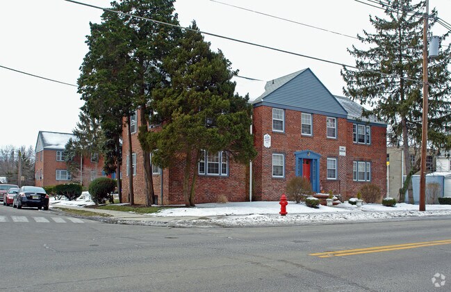
Property Record
450 Haddon Ave, Collingswood, NJ 08108


Save to a Folder
{{folder.Name}}
{{folder.ListingIds.length}} Properties
{{folder.ListingIds.length}} Property
Create a New Folder
Property Detail
450 Haddon Ave
Philadelphia-Camden-Wilmington, PA-NJ-DE-MD
21.01,22,23
12-00112-0000-00021
Camden
Apartment
New Jersey
B and X Area of moderate flood hazard, usually the area between the limits of the 100-year and 500-year floods.
21
2025
0.46 AC
2026
Cherry Hill/Haddonfield
604200
Philadelphia
NEARBY LISTINGS FOR SALE OR LEASE
-
-
-
No Photo
-
-
-
-
View all Collingswood listings for sale on LoopNet.com
DEMOGRAPHICS near 450 Haddon Ave
1 mile
3 mile
5 mile
2025 Total Population
18,574
174,995
464,260
2030 Population
18,829
179,962
470,148
Pop Growth 2025-2030
+ 1.37%
+ 2.84%
+ 1.27%
Average Age
40
38
39
2025 Total Households
8,315
65,558
190,998
HH Growth 2025-2030
+ 1.47%
+ 2.79%
+ 1.09%
Median Household Inc
$81,503
$71,135
$85,011
Avg Household Size
2.20
2.60
2.30
2025 Avg HH Vehicles
1.00
1.00
1.00
Median Home Value
$375,190
$283,721
$321,567
Median Year Built
1948
1950
1951
Nearby Places
Map Layers
Map Styles
 Street
 Aerial
Layers
 Traffic
 Biking
Places
Listings with unknown addresses are not visible on the map
- Restaurants
- Banks
- Shops
- Fitness
- Groceries
PUBLIC TRANSPORTATION
TRANSIT/SUBWAY
Collingswood (PATCO Speedline - Port Authority Transit Corporation Speedline (PATCO Speedline))
Drive
Walk
Distance
Collingswood (PATCO Speedline - Port Authority Transit Corporation Speedline (PATCO Speedline))
2 min
16 min
0.8 mi
Ferry Avenue (PATCO Speedline - Port Authority Transit Corporation Speedline (PATCO Speedline))
Drive
Walk
Distance
Ferry Avenue (PATCO Speedline - Port Authority Transit Corporation Speedline (PATCO Speedline))
3 min
19 min
1.0 mi
COMMUTER RAIL
Cherry Hill (Atlantic City Line - NJ Transit Commuter Rail (NJ Transit))
Drive
Walk
Distance
Cherry Hill (Atlantic City Line - NJ Transit Commuter Rail (NJ Transit))
7 min
3.2 mi
Drive
Walk
Distance
9 min
5.5 mi
AIRPORT
Philadelphia International
Drive
Walk
Distance
Philadelphia International
24 min
13.0 mi
Trenton Mercer
Drive
Walk
Distance
Trenton Mercer
52 min
36.2 mi
Atlantic City International
Drive
Walk
Distance
Atlantic City International
81 min
47.6 mi
Freight Ports
Broadway Terminal - Pier 5
Drive
Walk
Distance
Broadway Terminal - Pier 5
8 min
3.3 mi
Nearby Properties
Address
Land Use
TOTAL SIZE
Lot Size
Zoning
Address
Land Use
TOTAL SIZE
Lot Size
Zoning
1.17 AC
Address
Land Use
TOTAL SIZE
Lot Size
Zoning
7.17 AC
Address
Land Use
TOTAL SIZE
Lot Size
Zoning
124.13 AC
Address
Land Use
TOTAL SIZE
Lot Size
Zoning
Address
Land Use
TOTAL SIZE
Lot Size
Zoning
12.53 AC
Address
Land Use
TOTAL SIZE
Lot Size
Zoning
Address
Land Use
TOTAL SIZE
Lot Size
Zoning
2.32 AC
Address
Land Use
TOTAL SIZE
Lot Size
Zoning
7.11 AC
Address
Land Use
TOTAL SIZE
Lot Size
Zoning
49.16 AC
Address
Land Use
TOTAL SIZE
Lot Size
Zoning
8.50 AC
Address
Land Use
TOTAL SIZE
Lot Size
Zoning
10,292 SF
21.30 AC
Address
Land Use
TOTAL SIZE
Lot Size
Zoning
1.68 AC
Address
Land Use
TOTAL SIZE
Lot Size
Zoning
Address
Land Use
TOTAL SIZE
Lot Size
Zoning
31.99 AC
Address
Land Use
TOTAL SIZE
Lot Size
Zoning
16,872 SF
RH
Address
Land Use
TOTAL SIZE
Lot Size
Zoning
1,504 SF
61.44 AC
Address
Land Use
TOTAL SIZE
Lot Size
Zoning
39,080 SF
18.60 AC
C2
Address
Land Use
TOTAL SIZE
Lot Size
Zoning
1.48 AC
PCR
Address
Land Use
TOTAL SIZE
Lot Size
Zoning
17.62 AC
Address
Land Use
TOTAL SIZE
Lot Size
Zoning
35 AC
R1
Address
Land Use
TOTAL SIZE
Lot Size
Zoning
Address
Land Use
TOTAL SIZE
Lot Size
Zoning
14.11 AC
RG
Address
Land Use
TOTAL SIZE
Lot Size
Zoning
12.68 AC
RG
Address
Land Use
TOTAL SIZE
Lot Size
Zoning
2.09 AC
Address
Land Use
TOTAL SIZE
Lot Size
Zoning
16,796 SF
RH
Address
Land Use
TOTAL SIZE
Lot Size
Zoning
50,464 SF
20.22 AC
RH
Address
Land Use
TOTAL SIZE
Lot Size
Zoning
Address
Land Use
TOTAL SIZE
Lot Size
Zoning
2.32 AC
Address
Land Use
TOTAL SIZE
Lot Size
Zoning
Address
Land Use
TOTAL SIZE
Lot Size
Zoning
43.68 AC
The World's #1 Commercial Real Estate Marketplace
Connect with us
© 2026 CoStar Group
The information above has been obtained from sources believed reliable. While we do not doubt its accuracy we have not verified it and make no guarantee, warranty or representation about it. It is your responsibility to independently confirm its accuracy and completeness. Any projections, opinions, assumptions, or estimates used are for example only and do not represent the current or future performance of the property. The value of this transaction to you depends on tax and other factors which should be evaluated by your tax, financial, and legal advisors. You and your advisors should conduct a careful, independent investigation of the property to determine to your satisfaction the suitability of the property for your needs.