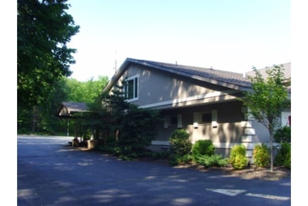
Property Record
450 Howard Blvd, Mount Arlington, NJ 07856

NEARBY LISTINGS FOR SALE OR LEASE
Property Detail
450 Howard Blvd
Newark, NJ
FACILITY NAME: CHURCH
26-00009-0000-00002-01
Morris
Restaurantbuilding
New Jersey
0
2.1
2025
5 AC
045404
Western Morris
12,130 SF
Northern New Jersey
DEMOGRAPHICS near 450 Howard Blvd
1 Mile
3 Mile
5 Mile
2024 Total Population
2,502
34,094
80,741
2029 Population
2,527
34,499
81,203
Pop Growth 2024-2029
+ 1.00%
+ 1.19%
+ 0.57%
Average Age
44
43
43
2024 Total Households
1,023
13,801
31,564
HH Growth 2024-2029
+ 0.88%
+ 1.23%
+ 0.63%
Median Household Inc
$98,112
$101,696
$96,418
Avg Household Size
2.40
2.40
2.50
2024 Avg HH Vehicles
2.00
2.00
2.00
Median Home Value
$442,105
$328,811
$335,579
Median Year Built
1966
1967
1968
Nearby Places
Map Layers
Map Styles
 Street
 Aerial
- Restaurants
- Banks
- Shops
- Fitness
- Groceries
PUBLIC TRANSPORTATION
COMMUTER RAIL
Mount Arlington (Montclair-Boonton Line - NJ Transit Commuter Rail (NJ Transit), Morris & Essex Morristown Line - NJ Transit Commuter Rail (NJ Transit))
DRIVE
WALK
Distance
Mount Arlington (Montclair-Boonton Line - NJ Transit Commuter Rail (NJ Transit), Morris & Essex Morristown Line - NJ Transit Commuter Rail (NJ Transit))
6 min
3.1 mi
Lake Hopatcong (Montclair-Boonton Line - NJ Transit Commuter Rail (NJ Transit), Morris & Essex Morristown Line - NJ Transit Commuter Rail (NJ Transit))
DRIVE
WALK
Distance
Lake Hopatcong (Montclair-Boonton Line - NJ Transit Commuter Rail (NJ Transit), Morris & Essex Morristown Line - NJ Transit Commuter Rail (NJ Transit))
7 min
3.4 mi
AIRPORT
Newark Liberty International
DRIVE
WALK
Distance
Newark Liberty International
52 min
39.6 mi
Freight Ports
Maher Terminal
DRIVE
WALK
Distance
Maher Terminal
55 min
40.1 mi
Nearby Properties
Address
Land Use
TOTAL SIZE
Lot Size
Zoning
Address
Land Use
TOTAL SIZE
Lot Size
Zoning
1,023 SF
143.31 AC
OR-3
Address
Land Use
TOTAL SIZE
Lot Size
Zoning
Address
Land Use
TOTAL SIZE
Lot Size
Zoning
44.67 AC
R2
Address
Land Use
TOTAL SIZE
Lot Size
Zoning
126,875 SF
7.02 AC
Address
Land Use
TOTAL SIZE
Lot Size
Zoning
55.26 AC
PUD
Address
Land Use
TOTAL SIZE
Lot Size
Zoning
68,844 SF
5 AC
PUD
Address
Land Use
TOTAL SIZE
Lot Size
Zoning
133,934 SF
21.46 AC
PUD
Address
Land Use
TOTAL SIZE
Lot Size
Zoning
27.96 AC
R2
Address
Land Use
TOTAL SIZE
Lot Size
Zoning
3.90 AC
RG-5
Address
Land Use
TOTAL SIZE
Lot Size
Zoning
10.76 AC
RG-5
Address
Land Use
TOTAL SIZE
Lot Size
Zoning
5.70 AC
RG-5
Address
Land Use
TOTAL SIZE
Lot Size
Zoning
43,525 SF
11 AC
RA30
Address
Land Use
TOTAL SIZE
Lot Size
Zoning
7.26 AC
A
Address
Land Use
TOTAL SIZE
Lot Size
Zoning
26.53 AC
R-5
Address
Land Use
TOTAL SIZE
Lot Size
Zoning
2,443 SF
6.73 AC
RAC2
Address
Land Use
TOTAL SIZE
Lot Size
Zoning
14.93 AC
R2
Address
Land Use
TOTAL SIZE
Lot Size
Zoning
87,970 SF
6.56 AC
PUD
Address
Land Use
TOTAL SIZE
Lot Size
Zoning
41,824 SF
8.84 AC
OB
Address
Land Use
TOTAL SIZE
Lot Size
Zoning
35,140 SF
7.96 AC
GU
Address
Land Use
TOTAL SIZE
Lot Size
Zoning
17.72 AC
C-2
Address
Land Use
TOTAL SIZE
Lot Size
Zoning
39,364 SF
7.61 AC
PUD
Address
Land Use
TOTAL SIZE
Lot Size
Zoning
75,572 SF
9.59 AC
HMC
Address
Land Use
TOTAL SIZE
Lot Size
Zoning
810 SF
3.52 AC
RG-5
Address
Land Use
TOTAL SIZE
Lot Size
Zoning
23,280 SF
3.04 AC
B1
Address
Land Use
TOTAL SIZE
Lot Size
Zoning
725.50 AC
OS
Address
Land Use
TOTAL SIZE
Lot Size
Zoning
1.74 AC
OB
Address
Land Use
TOTAL SIZE
Lot Size
Zoning
11.27 AC
C-1
Address
Land Use
TOTAL SIZE
Lot Size
Zoning
23,950 SF
15.84 AC
RA40
Address
Land Use
TOTAL SIZE
Lot Size
Zoning
2.80 AC
B2
Address
Land Use
TOTAL SIZE
Lot Size
Zoning
1,540 SF
30.13 AC
M1
The World's #1 Commercial Real Estate Marketplace
Connect with us
© 2026 CoStar Group
The information above has been obtained from sources believed reliable. While we do not doubt its accuracy we have not verified it and make no guarantee, warranty or representation about it. It is your responsibility to independently confirm its accuracy and completeness. Any projections, opinions, assumptions, or estimates used are for example only and do not represent the current or future performance of the property. The value of this transaction to you depends on tax and other factors which should be evaluated by your tax, financial, and legal advisors. You and your advisors should conduct a careful, independent investigation of the property to determine to your satisfaction the suitability of the property for your needs.