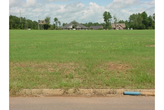
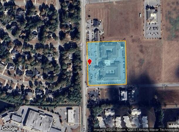
Property Record
450 John D Odom Rd, Dothan, AL 36303
Save to a Folder
{{folder.Name}}
{{folder.ListingIds.length}} Properties
{{folder.ListingIds.length}} Property
Create a New Folder
Property Detail
450 John D Odom Rd
09-04-17-0-000-002-004
LOC IN NW1/4 OF NE1/4 OF SEC 17 T3N R26E COM @ SE COR OF SEC TH N 278.09' W 865.34' TO POB TH W 441.11' N ALG R/W 487.18 ' E
Continuumofcareseniorsfacility
HOUSTON
B and X Area of moderate flood hazard, usually the area between the limits of the 100-year and 500-year floods.
Alabama
2025
4.87 AC
2025
Dothan/Enterprise
040204
Other Market Areas
2,426 SF
Dothan, AL
NEARBY LISTINGS FOR SALE OR LEASE
DEMOGRAPHICS near 450 John D Odom Rd
1 mile
3 mile
5 mile
2025 Total Population
3,917
29,922
56,924
2030 Population
3,909
30,014
57,614
Pop Growth 2025-2030
(0.20%)
+ 0.31%
+ 1.21%
Average Age
42
42
40
2025 Total Households
1,792
12,784
24,059
HH Growth 2025-2030
(0.11%)
+ 0.31%
+ 1.24%
Median Household Inc
$87,977
$80,602
$61,452
Avg Household Size
2.20
2.30
2.30
2025 Avg HH Vehicles
2.00
2.00
2.00
Median Home Value
$266,017
$247,035
$203,307
Median Year Built
1992
1989
1981
Nearby Places
Map Layers
Map Styles
 Street
 Aerial
Layers
 Traffic
 Biking
Places
Listings with unknown addresses are not visible on the map
- Restaurants
- Banks
- Shops
- Fitness
- Groceries
PUBLIC TRANSPORTATION
AIRPORT
Dothan Regional
Drive
Walk
Distance
Dothan Regional
14 min
5.8 mi
Freight Ports
Port of Panama City
Drive
Walk
Distance
Port of Panama City
116 min
88.3 mi
Nearby Properties
Address
Land Use
TOTAL SIZE
Lot Size
Zoning
Address
Land Use
TOTAL SIZE
Lot Size
Zoning
375,000 SF
16.80 AC
Address
Land Use
TOTAL SIZE
Lot Size
Zoning
1,938 SF
2 AC
Address
Land Use
TOTAL SIZE
Lot Size
Zoning
178,040 SF
30.41 AC
Address
Land Use
TOTAL SIZE
Lot Size
Zoning
2,000 SF
31.99 AC
Address
Land Use
TOTAL SIZE
Lot Size
Zoning
116,088 SF
10.27 AC
Address
Land Use
TOTAL SIZE
Lot Size
Zoning
1,848 SF
10 AC
Address
Land Use
TOTAL SIZE
Lot Size
Zoning
18,144 SF
13.37 AC
Address
Land Use
TOTAL SIZE
Lot Size
Zoning
420,000 SF
18.99 AC
Address
Land Use
TOTAL SIZE
Lot Size
Zoning
384 SF
2.69 AC
Address
Land Use
TOTAL SIZE
Lot Size
Zoning
152,685 SF
16.80 AC
Address
Land Use
TOTAL SIZE
Lot Size
Zoning
720 SF
12.39 AC
Address
Land Use
TOTAL SIZE
Lot Size
Zoning
85,473 SF
12.34 AC
Address
Land Use
TOTAL SIZE
Lot Size
Zoning
262,200 SF
11.51 AC
Address
Land Use
TOTAL SIZE
Lot Size
Zoning
312 SF
2.17 AC
Address
Land Use
TOTAL SIZE
Lot Size
Zoning
165,195 SF
12.71 AC
Address
Land Use
TOTAL SIZE
Lot Size
Zoning
42,500 SF
16.24 AC
Address
Land Use
TOTAL SIZE
Lot Size
Zoning
182 SF
0.53 AC
Address
Land Use
TOTAL SIZE
Lot Size
Zoning
106,000 SF
13.69 AC
Address
Land Use
TOTAL SIZE
Lot Size
Zoning
323 SF
60 AC
Address
Land Use
TOTAL SIZE
Lot Size
Zoning
1,794 SF
8.82 AC
Address
Land Use
TOTAL SIZE
Lot Size
Zoning
2,561 SF
10.19 AC
Address
Land Use
TOTAL SIZE
Lot Size
Zoning
45,696 SF
2.61 AC
Address
Land Use
TOTAL SIZE
Lot Size
Zoning
464,620 SF
15.65 AC
Address
Land Use
TOTAL SIZE
Lot Size
Zoning
46,920 SF
4.67 AC
Address
Land Use
TOTAL SIZE
Lot Size
Zoning
283,000 SF
11.20 AC
Address
Land Use
TOTAL SIZE
Lot Size
Zoning
252,200 SF
10.11 AC
Address
Land Use
TOTAL SIZE
Lot Size
Zoning
729 SF
4.36 AC
Address
Land Use
TOTAL SIZE
Lot Size
Zoning
52,270 SF
3.84 AC
Address
Land Use
TOTAL SIZE
Lot Size
Zoning
160,000 SF
4.83 AC
The World's #1 Commercial Real Estate Marketplace
Connect with us
© 2026 CoStar Group
The information above has been obtained from sources believed reliable. While we do not doubt its accuracy we have not verified it and make no guarantee, warranty or representation about it. It is your responsibility to independently confirm its accuracy and completeness. Any projections, opinions, assumptions, or estimates used are for example only and do not represent the current or future performance of the property. The value of this transaction to you depends on tax and other factors which should be evaluated by your tax, financial, and legal advisors. You and your advisors should conduct a careful, independent investigation of the property to determine to your satisfaction the suitability of the property for your needs.