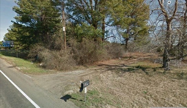
Property Record
450 Leary Rd, Larue, TX 75770

Property Detail
450 Leary Rd
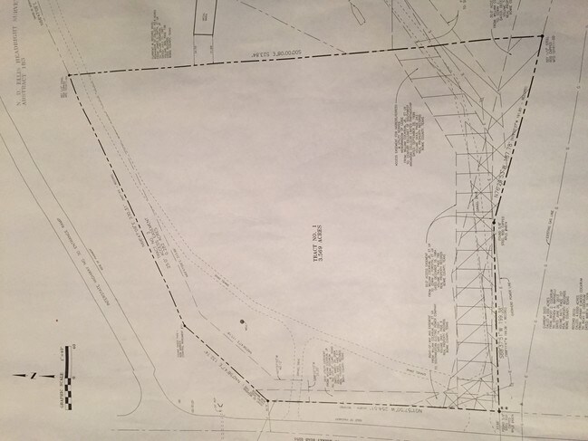
07180000100
N D ELLIS A-183 2017-8475 07/31/17 BLK/TRACT 1E 3.569 ACRES
Commercialnec
BOWIE
B and X Area of moderate flood hazard, usually the area between the limits of the 100-year and 500-year floods.
Texas
2025
3.57 AC
2025
Texas East Area
951402
Other Market Areas
7,560 SF
Texarkana, TX-AR
NEARBY LISTINGS FOR SALE OR LEASE
DEMOGRAPHICS near 450 Leary Rd
1 mile
3 mile
5 mile
2025 Total Population
254
3,155
15,042
2030 Population
255
3,160
14,954
Pop Growth 2025-2030
+ 0.39%
+ 0.16%
(0.59%)
Average Age
41
41
40
2025 Total Households
100
1,206
5,810
HH Growth 2025-2030
0.00%
+ 0.08%
(0.65%)
Median Household Inc
$77,500
$89,979
$68,962
Avg Household Size
2.50
2.60
2.60
2025 Avg HH Vehicles
2.00
2.00
2.00
Median Home Value
$214,286
$268,925
$226,335
Median Year Built
1993
1996
1991
Nearby Places
Map Layers
Map Styles
 Street
 Aerial
Layers
 Traffic
 Biking
Places
Listings with unknown addresses are not visible on the map
- Restaurants
- Banks
- Shops
- Fitness
- Groceries
PUBLIC TRANSPORTATION
AIRPORT
Texarkana Regional-Webb Field
Drive
Walk
Distance
Texarkana Regional-Webb Field
23 min
15.9 mi
Freight Ports
Port of Shreveport
Drive
Walk
Distance
Port of Shreveport
117 min
103.9 mi
SALE & LEASE HISTORY
LISTING DATE
SALE/LEASE

Mar 30, 2017
For Sale
Nearby Properties
Address
Land Use
TOTAL SIZE
Lot Size
Zoning
Address
Land Use
TOTAL SIZE
Lot Size
Zoning
73,862 SF
9.30 AC
Address
Land Use
TOTAL SIZE
Lot Size
Zoning
3.74 AC
Address
Land Use
TOTAL SIZE
Lot Size
Zoning
36,980 SF
3.90 AC
Address
Land Use
TOTAL SIZE
Lot Size
Zoning
17,418 SF
20 AC
Address
Land Use
TOTAL SIZE
Lot Size
Zoning
38,060 SF
78.08 AC
Address
Land Use
TOTAL SIZE
Lot Size
Zoning
36,240 SF
7.50 AC
Address
Land Use
TOTAL SIZE
Lot Size
Zoning
10,955 SF
14.14 AC
Address
Land Use
TOTAL SIZE
Lot Size
Zoning
165.54 AC
Address
Land Use
TOTAL SIZE
Lot Size
Zoning
9,196 SF
10.87 AC
Address
Land Use
TOTAL SIZE
Lot Size
Zoning
82,160 SF
20 AC
Address
Land Use
TOTAL SIZE
Lot Size
Zoning
467.73 AC
Address
Land Use
TOTAL SIZE
Lot Size
Zoning
6,187 SF
2.32 AC
Address
Land Use
TOTAL SIZE
Lot Size
Zoning
12,800 SF
0.82 AC
Address
Land Use
TOTAL SIZE
Lot Size
Zoning
13,045 SF
1.38 AC
Address
Land Use
TOTAL SIZE
Lot Size
Zoning
10,628 SF
1.67 AC
Address
Land Use
TOTAL SIZE
Lot Size
Zoning
31,328 SF
7.26 AC
Address
Land Use
TOTAL SIZE
Lot Size
Zoning
11,374 SF
6.18 AC
Address
Land Use
TOTAL SIZE
Lot Size
Zoning
11,880 SF
2.50 AC
Address
Land Use
TOTAL SIZE
Lot Size
Zoning
8,868 SF
1.15 AC
Address
Land Use
TOTAL SIZE
Lot Size
Zoning
1,120 SF
1.65 AC
Address
Land Use
TOTAL SIZE
Lot Size
Zoning
22,909 SF
4.40 AC
Address
Land Use
TOTAL SIZE
Lot Size
Zoning
3,580 SF
15 AC
Address
Land Use
TOTAL SIZE
Lot Size
Zoning
10,650 SF
7.12 AC
Address
Land Use
TOTAL SIZE
Lot Size
Zoning
414.46 AC
Address
Land Use
TOTAL SIZE
Lot Size
Zoning
9,036 SF
3 AC
Address
Land Use
TOTAL SIZE
Lot Size
Zoning
5,680 SF
5 AC
Address
Land Use
TOTAL SIZE
Lot Size
Zoning
4,648 SF
0.64 AC
Address
Land Use
TOTAL SIZE
Lot Size
Zoning
29,440 SF
1.72 AC
Address
Land Use
TOTAL SIZE
Lot Size
Zoning
2,965 SF
0.61 AC
Address
Land Use
TOTAL SIZE
Lot Size
Zoning
11,360 SF
4.60 AC
The World's #1 Commercial Real Estate Marketplace
Connect with us
© 2026 CoStar Group
The information above has been obtained from sources believed reliable. While we do not doubt its accuracy we have not verified it and make no guarantee, warranty or representation about it. It is your responsibility to independently confirm its accuracy and completeness. Any projections, opinions, assumptions, or estimates used are for example only and do not represent the current or future performance of the property. The value of this transaction to you depends on tax and other factors which should be evaluated by your tax, financial, and legal advisors. You and your advisors should conduct a careful, independent investigation of the property to determine to your satisfaction the suitability of the property for your needs.