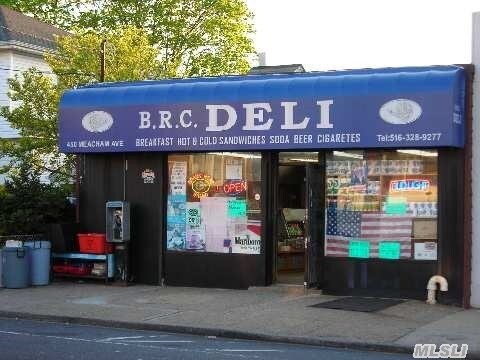
Property Record
450 Meacham Ave, Elmont, NY 11003
NEARBY LISTINGS FOR SALE OR LEASE
Property Detail
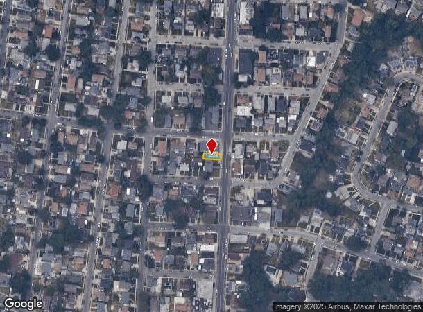
450 Meacham Ave
Nassau County-Suffolk County, NY
Map No 1 Of Hollis Circle
2089-32-588-00-0005-0
TOWN #1 SCH DIST 016
Commercialnec
Nassau
X
New York
36059C0205G
5
2025
0.04 AC
2025
Southern Nassau
405200
Long Island (New York)
2,375 SF
DEMOGRAPHICS near 450 Meacham Ave
1 Mile
3 Mile
5 Mile
2024 Total Population
31,828
267,594
799,475
2029 Population
30,453
256,895
763,697
Pop Growth 2024-2029
(4.32%)
(4.00%)
(4.48%)
Average Age
41
42
42
2024 Total Households
9,606
83,491
255,901
HH Growth 2024-2029
(4.41%)
(4.19%)
(4.72%)
Median Household Inc
$120,251
$120,458
$105,224
Avg Household Size
3.20
3.10
3.00
2024 Avg HH Vehicles
2.00
2.00
2.00
Median Home Value
$599,211
$644,464
$650,567
Median Year Built
1953
1949
1952
Nearby Places
- Restaurants
- Banks
- Shops
- Fitness
- Groceries
PUBLIC TRANSPORTATION
COMMUTER RAIL
Westwood Station (West Hempstead Branch - Long Island Rail Road)
DRIVE
WALK
Distance
Westwood Station (West Hempstead Branch - Long Island Rail Road)
5 min
2.4 mi
Malverne Station (West Hempstead Branch - Long Island Rail Road)
DRIVE
WALK
Distance
Malverne Station (West Hempstead Branch - Long Island Rail Road)
6 min
2.5 mi
AIRPORT
John F Kennedy International
DRIVE
WALK
Distance
John F Kennedy International
16 min
9.7 mi
LaGuardia
DRIVE
WALK
Distance
LaGuardia
25 min
14.6 mi
Newark Liberty International
DRIVE
WALK
Distance
Newark Liberty International
51 min
33.9 mi
Freight Ports
NY - Red Hook Container Terminal
DRIVE
WALK
Distance
NY - Red Hook Container Terminal
36 min
22.7 mi
SALE & LEASE HISTORY
LISTING DATE
SALE/LEASE

May 08, 2019
For Sale
Nearby Properties
Address
Land Use
TOTAL SIZE
Lot Size
Zoning
Address
Land Use
TOTAL SIZE
Lot Size
Zoning
129,378 SF
4.86 AC
R2A
Address
Land Use
TOTAL SIZE
Lot Size
Zoning
99,814 SF
1.31 AC
R3-2
Address
Land Use
TOTAL SIZE
Lot Size
Zoning
252,665 SF
7.50 AC
R3-2
Address
Land Use
TOTAL SIZE
Lot Size
Zoning
170,000 SF
4.02 AC
R3-2
Address
Land Use
TOTAL SIZE
Lot Size
Zoning
78,380 SF
0.85 AC
R3-2
Address
Land Use
TOTAL SIZE
Lot Size
Zoning
806 SF
84.15 AC
R2A
Address
Land Use
TOTAL SIZE
Lot Size
Zoning
260,000 SF
4.14 AC
R2
Address
Land Use
TOTAL SIZE
Lot Size
Zoning
85,330 SF
2.91 AC
R3-2
Address
Land Use
TOTAL SIZE
Lot Size
Zoning
32,000 SF
8.70 AC
M1-1
Address
Land Use
TOTAL SIZE
Lot Size
Zoning
108,051 SF
0.96 AC
C8-1
Address
Land Use
TOTAL SIZE
Lot Size
Zoning
53,700 SF
2.92 AC
R4-1
Address
Land Use
TOTAL SIZE
Lot Size
Zoning
59,426 SF
0.65 AC
C8-1
Address
Land Use
TOTAL SIZE
Lot Size
Zoning
63,976 SF
11.35 AC
R3-2
Address
Land Use
TOTAL SIZE
Lot Size
Zoning
105,036 SF
0.66 AC
M1-2
Address
Land Use
TOTAL SIZE
Lot Size
Zoning
73,300 SF
1.93 AC
R2
Address
Land Use
TOTAL SIZE
Lot Size
Zoning
41,712 SF
0.51 AC
R2A
Address
Land Use
TOTAL SIZE
Lot Size
Zoning
29,346 SF
4.32 AC
R3-2
Address
Land Use
TOTAL SIZE
Lot Size
Zoning
36,500 SF
2 AC
R2A
Address
Land Use
TOTAL SIZE
Lot Size
Zoning
79,750 SF
2.66 AC
R3A
Address
Land Use
TOTAL SIZE
Lot Size
Zoning
36,667 SF
2.65 AC
C8-1
Address
Land Use
TOTAL SIZE
Lot Size
Zoning
38,291 SF
0.50 AC
R4B
Address
Land Use
TOTAL SIZE
Lot Size
Zoning
46,962 SF
0.76 AC
R3-2
Address
Land Use
TOTAL SIZE
Lot Size
Zoning
15,960 SF
0.37 AC
C8-1
Address
Land Use
TOTAL SIZE
Lot Size
Zoning
2,634,357 SF
57.63 AC
Address
Land Use
TOTAL SIZE
Lot Size
Zoning
58,868 SF
0.76 AC
R3-2
Address
Land Use
TOTAL SIZE
Lot Size
Zoning
27,827 SF
0.16 AC
C4-2
Address
Land Use
TOTAL SIZE
Lot Size
Zoning
13,334 SF
2.11 AC
R2
Address
Land Use
TOTAL SIZE
Lot Size
Zoning
1,867,677 SF
385.47 AC
Address
Land Use
TOTAL SIZE
Lot Size
Zoning
19,488 SF
1.09 AC
R3-2
Address
Land Use
TOTAL SIZE
Lot Size
Zoning
72,000 SF
2.98 AC
M1-1
The World's #1 Commercial Real Estate Marketplace
Connect with us
© 2025 CoStar Group
The information above has been obtained from sources believed reliable. While we do not doubt its accuracy we have not verified it and make no guarantee, warranty or representation about it. It is your responsibility to independently confirm its accuracy and completeness. Any projections, opinions, assumptions, or estimates used are for example only and do not represent the current or future performance of the property. The value of this transaction to you depends on tax and other factors which should be evaluated by your tax, financial, and legal advisors. You and your advisors should conduct a careful, independent investigation of the property to determine to your satisfaction the suitability of the property for your needs.