Property Record
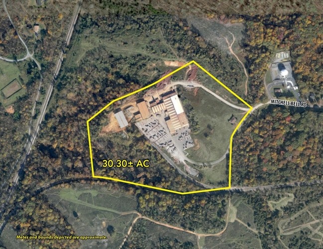
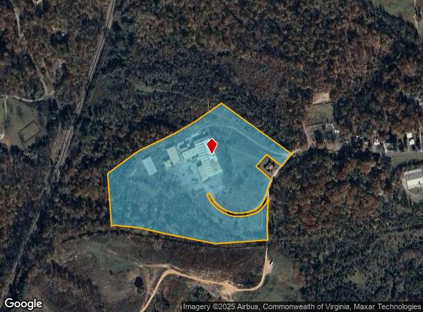
450 Mitchell Bell Rd, Madison Heights, VA 24572
This Property Is For Sale
NEARBY LISTINGS FOR SALE OR LEASE
-
-
View all Madison Heights listings for sale on LoopNet.com
Property Detail
450 Mitchell Bell Rd
147-A-229
PT OF OAK PARK FARM SEE DB 425-139 147 A 229
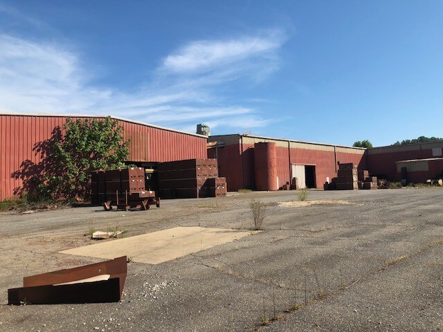
Warehouse
Amherst
X
Virginia
51009C0385C
30.13 AC
2024
Lynchburg
2025
Other Market Areas
010504
Lynchburg, VA
109,470 SF
DEMOGRAPHICS near 450 Mitchell Bell Rd
1 Mile
3 Mile
5 Mile
2024 Total Population
495
17,774
51,903
2029 Population
501
18,017
52,368
Pop Growth 2024-2029
+ 1.21%
+ 1.37%
+ 0.90%
Average Age
43
40
39
2024 Total Households
209
7,592
21,386
HH Growth 2024-2029
+ 0.96%
+ 1.44%
+ 0.95%
Median Household Inc
$62,647
$55,972
$53,020
Avg Household Size
2.40
2.20
2.30
2024 Avg HH Vehicles
2.00
2.00
2.00
Median Home Value
$172,727
$172,296
$175,368
Median Year Built
1969
1964
1963
Nearby Places
Map Layers
Map Styles
 Street
 Aerial
- Restaurants
- Banks
- Shops
- Fitness
- Groceries
PUBLIC TRANSPORTATION
COMMUTER RAIL
Lynchburg (Crescent - Amtrak, Northeast Regional - Amtrak)
DRIVE
WALK
Distance
Lynchburg (Crescent - Amtrak, Northeast Regional - Amtrak)
13 min
7.6 mi
AIRPORT
Lynchburg Regional/Preston Glenn Field
DRIVE
WALK
Distance
Lynchburg Regional/Preston Glenn Field
25 min
15.0 mi
Freight Ports
Virginia Port Authority - Richmond
DRIVE
WALK
Distance
Virginia Port Authority - Richmond
157 min
113.1 mi
Nearby Properties
Address
Land Use
TOTAL SIZE
Lot Size
Zoning
Address
Land Use
TOTAL SIZE
Lot Size
Zoning
20.17 AC
251921
Address
Land Use
TOTAL SIZE
Lot Size
Zoning
516,183 SF
16.46 AC
R1
Address
Land Use
TOTAL SIZE
Lot Size
Zoning
626,329 SF
50.88 AC
2521
Address
Land Use
TOTAL SIZE
Lot Size
Zoning
28.74 AC
Address
Land Use
TOTAL SIZE
Lot Size
Zoning
21,542 SF
41.78 AC
R2
Address
Land Use
TOTAL SIZE
Lot Size
Zoning
108,105 SF
108.66 AC
R1R2
Address
Land Use
TOTAL SIZE
Lot Size
Zoning
157,498 SF
11.25 AC
R3
Address
Land Use
TOTAL SIZE
Lot Size
Zoning
66,832 SF
48.77 AC
B2
Address
Land Use
TOTAL SIZE
Lot Size
Zoning
150,883 SF
7.41 AC
R4
Address
Land Use
TOTAL SIZE
Lot Size
Zoning
19.97 AC
R1
Address
Land Use
TOTAL SIZE
Lot Size
Zoning
64,610 SF
20.90 AC
R1R4
Address
Land Use
TOTAL SIZE
Lot Size
Zoning
134,387 SF
12.17 AC
B2
Address
Land Use
TOTAL SIZE
Lot Size
Zoning
9.79 AC
B2
Address
Land Use
TOTAL SIZE
Lot Size
Zoning
61,415 SF
24.11 AC
P1
Address
Land Use
TOTAL SIZE
Lot Size
Zoning
154,922 SF
16.89 AC
B2
Address
Land Use
TOTAL SIZE
Lot Size
Zoning
128,488 SF
15.60 AC
B2
Address
Land Use
TOTAL SIZE
Lot Size
Zoning
45,622 SF
8.54 AC
R1
Address
Land Use
TOTAL SIZE
Lot Size
Zoning
56,400 SF
3.67 AC
R3
Address
Land Use
TOTAL SIZE
Lot Size
Zoning
37,488 SF
0.88 AC
B1
Address
Land Use
TOTAL SIZE
Lot Size
Zoning
48,954 SF
5.84 AC
R1
Address
Land Use
TOTAL SIZE
Lot Size
Zoning
30,537 SF
5.91 AC
B2
Address
Land Use
TOTAL SIZE
Lot Size
Zoning
120,428 SF
4.22 AC
R1
Address
Land Use
TOTAL SIZE
Lot Size
Zoning
76,170 SF
2.67 AC
R4
Address
Land Use
TOTAL SIZE
Lot Size
Zoning
32,720 SF
0.45 AC
R1
Address
Land Use
TOTAL SIZE
Lot Size
Zoning
281,433 SF
3.89 AC
I3
Address
Land Use
TOTAL SIZE
Lot Size
Zoning
149,422 SF
6.98 AC
M1
Address
Land Use
TOTAL SIZE
Lot Size
Zoning
56,122 SF
0.94 AC
R3
Address
Land Use
TOTAL SIZE
Lot Size
Zoning
57,851 SF
1.93 AC
I2
The World's #1 Commercial Real Estate Marketplace
Connect with us
© 2026 CoStar Group
The information above has been obtained from sources believed reliable. While we do not doubt its accuracy we have not verified it and make no guarantee, warranty or representation about it. It is your responsibility to independently confirm its accuracy and completeness. Any projections, opinions, assumptions, or estimates used are for example only and do not represent the current or future performance of the property. The value of this transaction to you depends on tax and other factors which should be evaluated by your tax, financial, and legal advisors. You and your advisors should conduct a careful, independent investigation of the property to determine to your satisfaction the suitability of the property for your needs.