Property Record
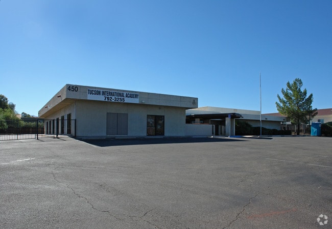
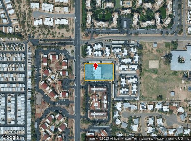
450 N Pantano Rd, Tucson, AZ 85710

NEARBY LISTINGS FOR SALE OR LEASE
-
-
View all Tucson listings for lease on LoopNet.com
Property Detail
450 N Pantano Rd
Tucson, AZ
Null
133-24-005E
S170 N442.1 E292 W367 NW4 SW4 1.14 AC SEC 9-14-15 (RD 6484/905)
Privateschool
Pima
X
Arizona
04019C2302L
10
0
1.14 AC
2025
East Tucson
004071
Tucson
8,391 SF
DEMOGRAPHICS near 450 N Pantano Rd
1 Mile
3 Mile
5 Mile
2024 Total Population
17,926
114,179
223,243
2029 Population
18,761
117,948
230,594
Pop Growth 2024-2029
+ 4.66%
+ 3.30%
+ 3.29%
Average Age
44
42
42
2024 Total Households
9,680
52,762
99,644
HH Growth 2024-2029
+ 4.81%
+ 3.38%
+ 3.35%
Median Household Inc
$42,852
$54,873
$57,111
Avg Household Size
1.80
2.10
2.10
2024 Avg HH Vehicles
1.00
2.00
2.00
Median Home Value
$194,128
$242,760
$252,146
Median Year Built
1982
1977
1977
Nearby Places
Map Layers
Map Styles
 Street
 Aerial
- Restaurants
- Banks
- Shops
- Fitness
- Groceries
PUBLIC TRANSPORTATION
COMMUTER RAIL
DRIVE
WALK
Distance
20 min
9.0 mi
AIRPORT
Tucson International
DRIVE
WALK
Distance
Tucson International
26 min
14.0 mi
SALE & LEASE HISTORY
LISTING DATE
SALE/LEASE

Sep 17, 2024
For Lease
Sep 16, 2024
For Sale
Nearby Properties
Address
Land Use
TOTAL SIZE
Lot Size
Zoning
Address
Land Use
TOTAL SIZE
Lot Size
Zoning
53,431 SF
9.98 AC
Address
Land Use
TOTAL SIZE
Lot Size
Zoning
88,741 SF
8.02 AC
Address
Land Use
TOTAL SIZE
Lot Size
Zoning
684,356 SF
19.65 AC
PAD13
Address
Land Use
TOTAL SIZE
Lot Size
Zoning
473,573 SF
22.65 AC
C3
Address
Land Use
TOTAL SIZE
Lot Size
Zoning
97,724 SF
15.38 AC
SR
Address
Land Use
TOTAL SIZE
Lot Size
Zoning
41,486 SF
0.93 AC
C2
Address
Land Use
TOTAL SIZE
Lot Size
Zoning
318,290 SF
32 AC
R1
Address
Land Use
TOTAL SIZE
Lot Size
Zoning
504,584 SF
18.17 AC
O3
Address
Land Use
TOTAL SIZE
Lot Size
Zoning
278,632 SF
37.62 AC
RX1
Address
Land Use
TOTAL SIZE
Lot Size
Zoning
430,180 SF
19.78 AC
R3
Address
Land Use
TOTAL SIZE
Lot Size
Zoning
11,074 SF
0.94 AC
C1
Address
Land Use
TOTAL SIZE
Lot Size
Zoning
209,980 SF
6.16 AC
C2
Address
Land Use
TOTAL SIZE
Lot Size
Zoning
26,554 SF
5.08 AC
I1
Address
Land Use
TOTAL SIZE
Lot Size
Zoning
364,128 SF
11.55 AC
O3
Address
Land Use
TOTAL SIZE
Lot Size
Zoning
109,335 SF
7.83 AC
PAD13
Address
Land Use
TOTAL SIZE
Lot Size
Zoning
256,775 SF
6.69 AC
C1
Address
Land Use
TOTAL SIZE
Lot Size
Zoning
322,009 SF
17.96 AC
Address
Land Use
TOTAL SIZE
Lot Size
Zoning
180,149 SF
17.48 AC
PAD3
Address
Land Use
TOTAL SIZE
Lot Size
Zoning
1,804 SF
8.29 AC
R3
Address
Land Use
TOTAL SIZE
Lot Size
Zoning
162,473 SF
6.08 AC
C3
Address
Land Use
TOTAL SIZE
Lot Size
Zoning
21,928 SF
41.39 AC
SR
Address
Land Use
TOTAL SIZE
Lot Size
Zoning
240,585 SF
18.16 AC
R2
Address
Land Use
TOTAL SIZE
Lot Size
Zoning
265,649 SF
12.63 AC
R3
Address
Land Use
TOTAL SIZE
Lot Size
Zoning
145,152 SF
11.54 AC
C2
Address
Land Use
TOTAL SIZE
Lot Size
Zoning
128,894 SF
10.06 AC
C1
Address
Land Use
TOTAL SIZE
Lot Size
Zoning
286,164 SF
5.80 AC
C3
Address
Land Use
TOTAL SIZE
Lot Size
Zoning
273,640 SF
21.20 AC
O3
Address
Land Use
TOTAL SIZE
Lot Size
Zoning
188,350 SF
10.81 AC
Address
Land Use
TOTAL SIZE
Lot Size
Zoning
289,997 SF
21.55 AC
CR2
Address
Land Use
TOTAL SIZE
Lot Size
Zoning
118,655 SF
8.74 AC
C1
The World's #1 Commercial Real Estate Marketplace
Connect with us
© 2026 CoStar Group
The information above has been obtained from sources believed reliable. While we do not doubt its accuracy we have not verified it and make no guarantee, warranty or representation about it. It is your responsibility to independently confirm its accuracy and completeness. Any projections, opinions, assumptions, or estimates used are for example only and do not represent the current or future performance of the property. The value of this transaction to you depends on tax and other factors which should be evaluated by your tax, financial, and legal advisors. You and your advisors should conduct a careful, independent investigation of the property to determine to your satisfaction the suitability of the property for your needs.