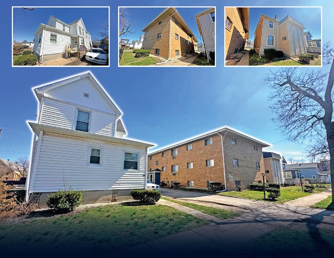
Property Record
450 S Dearborn Ave, Kankakee, IL 60901


NEARBY LISTINGS FOR SALE OR LEASE
-
-
View all Kankakee listings for sale on LoopNet.com
Property Detail
450 S Dearborn Ave
Kankakee, IL
Town Of Kankakee City
16-17-05-114-005
TOWN OF KANKAKEE SH LOT 7 & LOT 10 BLK 40 05-30-13W
Apartmenthouse5plusunits
Kankakee
X
Illinois
17075C0075E
7,10
2024
0.25 AC
2024
Illinois North Area
012300
Other Market Areas
DEMOGRAPHICS near 450 S Dearborn Ave
1 mile
3 mile
5 mile
2024 Total Population
13,268
39,185
66,048
2029 Population
13,178
38,554
64,854
Pop Growth 2024-2029
(0.68%)
(1.61%)
(1.81%)
Average Age
36
38
39
2024 Total Households
4,930
14,934
25,069
HH Growth 2024-2029
(0.67%)
(1.70%)
(1.91%)
Median Household Inc
$40,143
$47,563
$60,388
Avg Household Size
2.50
2.40
2.40
2024 Avg HH Vehicles
1.00
2.00
2.00
Median Home Value
$86,002
$127,314
$162,605
Median Year Built
1948
1959
1969
Nearby Places
Map Layers
Map Styles
 Street
 Aerial
Transit
 Traffic
 Biking
Places
Listings with unknown addresses are not visible on the map
- Restaurants
- Banks
- Shops
- Fitness
- Groceries
PUBLIC TRANSPORTATION
COMMUTER RAIL
Kankakee (City of New Orleans - Amtrak, Illini - Amtrak, Saluki - Amtrak)
Drive
Walk
Distance
Kankakee (City of New Orleans - Amtrak, Illini - Amtrak, Saluki - Amtrak)
1 min
7 min
0.4 mi
Freight Ports
Port Milwaukee
Drive
Walk
Distance
Port Milwaukee
176 min
144.1 mi
SALE & LEASE HISTORY
LISTING DATE
SALE/LEASE

Aug 08, 2018
For Sale
Nearby Properties
Address
Land Use
TOTAL SIZE
Lot Size
Zoning
Address
Land Use
TOTAL SIZE
Lot Size
Zoning
43.69 AC
Address
Land Use
TOTAL SIZE
Lot Size
Zoning
Address
Land Use
TOTAL SIZE
Lot Size
Zoning
22.78 AC
Address
Land Use
TOTAL SIZE
Lot Size
Zoning
14.19 AC
I1
Address
Land Use
TOTAL SIZE
Lot Size
Zoning
4.60 AC
Address
Land Use
TOTAL SIZE
Lot Size
Zoning
20.84 AC
I2
Address
Land Use
TOTAL SIZE
Lot Size
Zoning
Address
Land Use
TOTAL SIZE
Lot Size
Zoning
11.40 AC
Address
Land Use
TOTAL SIZE
Lot Size
Zoning
1.70 AC
Address
Land Use
TOTAL SIZE
Lot Size
Zoning
27.09 AC
Address
Land Use
TOTAL SIZE
Lot Size
Zoning
Address
Land Use
TOTAL SIZE
Lot Size
Zoning
13.50 AC
Address
Land Use
TOTAL SIZE
Lot Size
Zoning
Address
Land Use
TOTAL SIZE
Lot Size
Zoning
34 AC
I2
Address
Land Use
TOTAL SIZE
Lot Size
Zoning
23.74 AC
Address
Land Use
TOTAL SIZE
Lot Size
Zoning
33.55 AC
Address
Land Use
TOTAL SIZE
Lot Size
Zoning
29.11 AC
Address
Land Use
TOTAL SIZE
Lot Size
Zoning
1.33 AC
Address
Land Use
TOTAL SIZE
Lot Size
Zoning
0.51 AC
Address
Land Use
TOTAL SIZE
Lot Size
Zoning
2.17 AC
Address
Land Use
TOTAL SIZE
Lot Size
Zoning
46.40 AC
I2
Address
Land Use
TOTAL SIZE
Lot Size
Zoning
2.85 AC
Address
Land Use
TOTAL SIZE
Lot Size
Zoning
5.35 AC
Address
Land Use
TOTAL SIZE
Lot Size
Zoning
0.65 AC
Address
Land Use
TOTAL SIZE
Lot Size
Zoning
2.94 AC
Address
Land Use
TOTAL SIZE
Lot Size
Zoning
Address
Land Use
TOTAL SIZE
Lot Size
Zoning
11.73 AC
Address
Land Use
TOTAL SIZE
Lot Size
Zoning
0.34 AC
Address
Land Use
TOTAL SIZE
Lot Size
Zoning
4.59 AC
Address
Land Use
TOTAL SIZE
Lot Size
Zoning
4.53 AC
The World's #1 Commercial Real Estate Marketplace
Connect with us
© 2026 CoStar Group
The information above has been obtained from sources believed reliable. While we do not doubt its accuracy we have not verified it and make no guarantee, warranty or representation about it. It is your responsibility to independently confirm its accuracy and completeness. Any projections, opinions, assumptions, or estimates used are for example only and do not represent the current or future performance of the property. The value of this transaction to you depends on tax and other factors which should be evaluated by your tax, financial, and legal advisors. You and your advisors should conduct a careful, independent investigation of the property to determine to your satisfaction the suitability of the property for your needs.