Property Record
450 S Decatur Blvd, Las Vegas, NV 89107


NEARBY LISTINGS FOR SALE OR LEASE
-
-
-
-
-
-
SEC Westwood Dr @ West Charleston Blvd.
Las Vegas, NV 89102
Rent Upon Request
0.14 - 1.92 AC Lot
Land
-
-
-
-
-
-
-
-
-
-
-
-
-
-
-
View all Las Vegas listings for lease on LoopNet.com
Property Detail
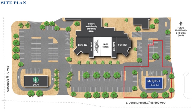
450 S Decatur Blvd
Las Vegas-Henderson-Paradise, NV
Decatur And Alta
138-36-613-008
DECATUR AND ALTA PLAT BOOK 162 PAGE 24 PT LOT 1
Vacantlandnec
Clark
X
Nevada
32003C2165D
1
2024
1.57 AC
2025
Northwest Las Vegas
000106
Las Vegas
DEMOGRAPHICS near 450 S Decatur Blvd
1 Mile
3 Mile
5 Mile
2024 Total Population
21,346
183,931
492,489
2029 Population
22,854
197,754
529,643
Pop Growth 2024-2029
+ 7.06%
+ 7.52%
+ 7.54%
Average Age
40
38
39
2024 Total Households
7,603
67,416
194,731
HH Growth 2024-2029
+ 7.26%
+ 7.52%
+ 7.62%
Median Household Inc
$41,224
$43,773
$45,519
Avg Household Size
2.70
2.60
2.40
2024 Avg HH Vehicles
2.00
2.00
2.00
Median Home Value
$243,249
$272,636
$305,544
Median Year Built
1970
1981
1986
Nearby Places
Map Layers
Map Styles
 Street
 Aerial
- Restaurants
- Banks
- Shops
- Fitness
- Groceries
PUBLIC TRANSPORTATION
AIRPORT
Harry Reid International
DRIVE
WALK
Distance
Harry Reid International
50 min
15.0 mi
Boulder City Municipal
DRIVE
WALK
Distance
Boulder City Municipal
40 min
30.1 mi
SALE & LEASE HISTORY
LISTING DATE
SALE/LEASE

Jan 10, 2023
For Lease
Nearby Properties
Address
Land Use
TOTAL SIZE
Lot Size
Zoning
Address
Land Use
TOTAL SIZE
Lot Size
Zoning
315,865 SF
19.85 AC
Address
Land Use
TOTAL SIZE
Lot Size
Zoning
34,354 SF
33.06 AC
Address
Land Use
TOTAL SIZE
Lot Size
Zoning
1,617,320 SF
7.21 AC
PD
Address
Land Use
TOTAL SIZE
Lot Size
Zoning
115,059 SF
30.12 AC
Address
Land Use
TOTAL SIZE
Lot Size
Zoning
1,283,663 SF
8.56 AC
PD
Address
Land Use
TOTAL SIZE
Lot Size
Zoning
80.45 AC
CV
Address
Land Use
TOTAL SIZE
Lot Size
Zoning
573,491 SF
38.94 AC
Address
Land Use
TOTAL SIZE
Lot Size
Zoning
34.83 AC
CV
Address
Land Use
TOTAL SIZE
Lot Size
Zoning
814,789 SF
13.75 AC
C1
Address
Land Use
TOTAL SIZE
Lot Size
Zoning
38.80 AC
CV
Address
Land Use
TOTAL SIZE
Lot Size
Zoning
64,229 SF
15.49 AC
Address
Land Use
TOTAL SIZE
Lot Size
Zoning
88,160 SF
18.56 AC
Address
Land Use
TOTAL SIZE
Lot Size
Zoning
8.96 AC
L:PD
Address
Land Use
TOTAL SIZE
Lot Size
Zoning
22,018 SF
6.91 AC
Address
Land Use
TOTAL SIZE
Lot Size
Zoning
49,716 SF
59.37 AC
CV
Address
Land Use
TOTAL SIZE
Lot Size
Zoning
12.23 AC
PF
Address
Land Use
TOTAL SIZE
Lot Size
Zoning
28,956 SF
75.82 AC
CV
Address
Land Use
TOTAL SIZE
Lot Size
Zoning
5,057 SF
9.46 AC
RE
Address
Land Use
TOTAL SIZE
Lot Size
Zoning
3,518 SF
11.95 AC
Address
Land Use
TOTAL SIZE
Lot Size
Zoning
8,261 SF
9.36 AC
Address
Land Use
TOTAL SIZE
Lot Size
Zoning
271,484 SF
7.04 AC
C2
Address
Land Use
TOTAL SIZE
Lot Size
Zoning
322,005 SF
29.37 AC
C1
Address
Land Use
TOTAL SIZE
Lot Size
Zoning
6,558 SF
23.36 AC
R3
Address
Land Use
TOTAL SIZE
Lot Size
Zoning
52,058 SF
6.44 AC
C1
Address
Land Use
TOTAL SIZE
Lot Size
Zoning
66.57 AC
CV
Address
Land Use
TOTAL SIZE
Lot Size
Zoning
12,212 SF
8.29 AC
C1
Address
Land Use
TOTAL SIZE
Lot Size
Zoning
285,929 SF
5.06 AC
C1
Address
Land Use
TOTAL SIZE
Lot Size
Zoning
211,331 SF
6.70 AC
USC
The World's #1 Commercial Real Estate Marketplace
Connect with us
© 2026 CoStar Group
The information above has been obtained from sources believed reliable. While we do not doubt its accuracy we have not verified it and make no guarantee, warranty or representation about it. It is your responsibility to independently confirm its accuracy and completeness. Any projections, opinions, assumptions, or estimates used are for example only and do not represent the current or future performance of the property. The value of this transaction to you depends on tax and other factors which should be evaluated by your tax, financial, and legal advisors. You and your advisors should conduct a careful, independent investigation of the property to determine to your satisfaction the suitability of the property for your needs.