Property Record
450 S Mock Rd, Albany, GA 31705
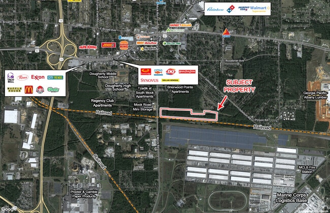

This Property Is For Sale
NEARBY LISTINGS FOR SALE OR LEASE
Property Detail
450 S Mock Rd
Albany, GA
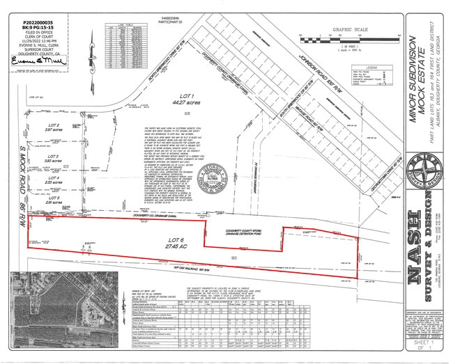
S Mock Rd
000RR/00011/08A
PT LL 163,1ST DIST
Commercialacreage
Dougherty
X
Georgia
13321C0175D
27.45 AC
2024
Albany/Southwest
2024
Other Market Areas
000102
DEMOGRAPHICS near 450 S Mock Rd
1 Mile
3 Mile
5 Mile
2024 Total Population
3,289
19,658
40,177
2029 Population
3,170
19,158
39,221
Pop Growth 2024-2029
(3.62%)
(2.54%)
(2.38%)
Average Age
34
35
37
2024 Total Households
1,383
7,354
15,940
HH Growth 2024-2029
(3.83%)
(2.77%)
(2.43%)
Median Household Inc
$27,757
$28,260
$31,826
Avg Household Size
2.30
2.40
2.30
2024 Avg HH Vehicles
1.00
1.00
1.00
Median Home Value
$55,037
$67,705
$81,081
Median Year Built
1973
1972
1971
Nearby Places
Map Layers
Map Styles
 Street
 Aerial
- Restaurants
- Banks
- Shops
- Fitness
- Groceries
PUBLIC TRANSPORTATION
AIRPORT
Southwest Georgia Regional
DRIVE
WALK
Distance
Southwest Georgia Regional
18 min
8.8 mi
Freight Ports
Port of Panama City
DRIVE
WALK
Distance
Port of Panama City
238 min
163.0 mi
Nearby Properties
Address
Land Use
TOTAL SIZE
Lot Size
Zoning
Address
Land Use
TOTAL SIZE
Lot Size
Zoning
34,888 SF
164.47 AC
M2
Address
Land Use
TOTAL SIZE
Lot Size
Zoning
243,722 SF
226.11 AC
M2
Address
Land Use
TOTAL SIZE
Lot Size
Zoning
1,445,486 SF
108.05 AC
M1
Address
Land Use
TOTAL SIZE
Lot Size
Zoning
58.86 AC
C3
Address
Land Use
TOTAL SIZE
Lot Size
Zoning
3,664 SF
1,672.02 AC
C1
Address
Land Use
TOTAL SIZE
Lot Size
Zoning
2,100 SF
9.92 AC
M1
Address
Land Use
TOTAL SIZE
Lot Size
Zoning
50,000 SF
50.37 AC
C3
Address
Land Use
TOTAL SIZE
Lot Size
Zoning
141,600 SF
45.43 AC
C1
Address
Land Use
TOTAL SIZE
Lot Size
Zoning
653,525 SF
324.66 AC
M2
Address
Land Use
TOTAL SIZE
Lot Size
Zoning
288,982 SF
39.52 AC
M1
Address
Land Use
TOTAL SIZE
Lot Size
Zoning
9,000 SF
184.88 AC
M2
Address
Land Use
TOTAL SIZE
Lot Size
Zoning
382,331 SF
30.50 AC
M1
Address
Land Use
TOTAL SIZE
Lot Size
Zoning
155,970 SF
20.89 AC
C3
Address
Land Use
TOTAL SIZE
Lot Size
Zoning
475,976 SF
51.30 AC
M1
Address
Land Use
TOTAL SIZE
Lot Size
Zoning
23,040 SF
10.59 AC
R6
Address
Land Use
TOTAL SIZE
Lot Size
Zoning
13,958 SF
15 AC
M1
Address
Land Use
TOTAL SIZE
Lot Size
Zoning
28,713 SF
9.96 AC
C3
Address
Land Use
TOTAL SIZE
Lot Size
Zoning
30,336 SF
19.19 AC
R6
Address
Land Use
TOTAL SIZE
Lot Size
Zoning
5,560 SF
12.88 AC
R6
Address
Land Use
TOTAL SIZE
Lot Size
Zoning
10,608 SF
45.66 AC
M1
Address
Land Use
TOTAL SIZE
Lot Size
Zoning
1,896 SF
1,413.84 AC
AG
Address
Land Use
TOTAL SIZE
Lot Size
Zoning
52,844 SF
18.09 AC
R6
Address
Land Use
TOTAL SIZE
Lot Size
Zoning
34,560 SF
7.46 AC
R6
Address
Land Use
TOTAL SIZE
Lot Size
Zoning
3,397 SF
7.93 AC
R6
Address
Land Use
TOTAL SIZE
Lot Size
Zoning
12,544 SF
10.72 AC
R6
Address
Land Use
TOTAL SIZE
Lot Size
Zoning
2,726 SF
6.29 AC
R6
Address
Land Use
TOTAL SIZE
Lot Size
Zoning
36,000 SF
5.07 AC
C3
Address
Land Use
TOTAL SIZE
Lot Size
Zoning
61,412 SF
8.88 AC
M1
Address
Land Use
TOTAL SIZE
Lot Size
Zoning
60,110 SF
77.98 AC
M1
Address
Land Use
TOTAL SIZE
Lot Size
Zoning
87,364 SF
11.38 AC
R1A
The World's #1 Commercial Real Estate Marketplace
Connect with us
© 2026 CoStar Group
The information above has been obtained from sources believed reliable. While we do not doubt its accuracy we have not verified it and make no guarantee, warranty or representation about it. It is your responsibility to independently confirm its accuracy and completeness. Any projections, opinions, assumptions, or estimates used are for example only and do not represent the current or future performance of the property. The value of this transaction to you depends on tax and other factors which should be evaluated by your tax, financial, and legal advisors. You and your advisors should conduct a careful, independent investigation of the property to determine to your satisfaction the suitability of the property for your needs.