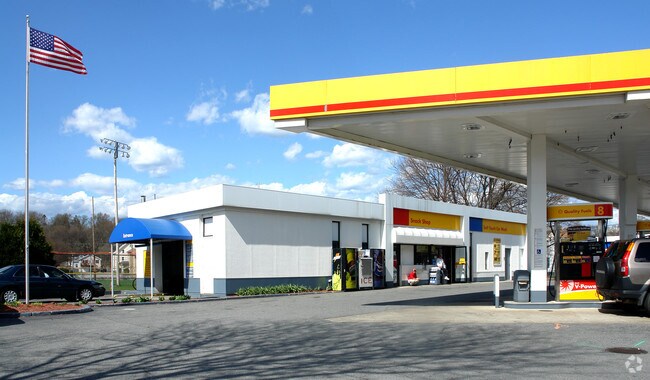
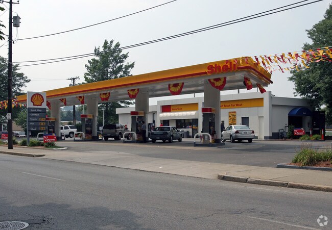
Property Record
450 Social St, Woonsocket, RI 02895
NEARBY LISTINGS FOR SALE OR LEASE
Property Detail
450 Social St
WOON-000022J-000145-000017
Providence
Commercialnec
Rhode Island
AE
145
25021C0300E
0.81 AC
2025
Woonsocket
2025
Providence
018000
Providence-Warwick, RI-MA
DEMOGRAPHICS near 450 Social St
1 Mile
3 Mile
5 Mile
2024 Total Population
23,428
64,479
96,321
2029 Population
23,166
63,904
95,632
Pop Growth 2024-2029
(1.12%)
(0.89%)
(0.72%)
Average Age
39
40
41
2024 Total Households
10,206
26,617
38,977
HH Growth 2024-2029
(1.19%)
(0.99%)
(0.82%)
Median Household Inc
$46,252
$61,789
$73,485
Avg Household Size
2.20
2.30
2.40
2024 Avg HH Vehicles
1.00
2.00
2.00
Median Home Value
$245,483
$303,913
$351,872
Median Year Built
1948
1956
1963
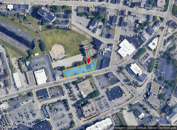
Nearby Places
Map Layers
Map Styles
 Street
 Aerial
- Restaurants
- Banks
- Shops
- Fitness
- Groceries
PUBLIC TRANSPORTATION
COMMUTER RAIL
Forge Park/Route 495 (Franklin Line - Massachusetts Bay Transportation Authority Commuter Rail (Purple Line))
DRIVE
WALK
Distance
Forge Park/Route 495 (Franklin Line - Massachusetts Bay Transportation Authority Commuter Rail (Purple Line))
16 min
8.4 mi
Franklin (Franklin Line - Massachusetts Bay Transportation Authority Commuter Rail (Purple Line))
DRIVE
WALK
Distance
Franklin (Franklin Line - Massachusetts Bay Transportation Authority Commuter Rail (Purple Line))
18 min
8.8 mi
AIRPORT
Rhode Island Tf Green International
DRIVE
WALK
Distance
Rhode Island Tf Green International
35 min
23.5 mi
Worcester Regional
DRIVE
WALK
Distance
Worcester Regional
46 min
32.4 mi
Freight Ports
Port of Davisville, RI
DRIVE
WALK
Distance
Port of Davisville, RI
48 min
35.0 mi
Nearby Properties
Address
Land Use
TOTAL SIZE
Lot Size
Zoning
Address
Land Use
TOTAL SIZE
Lot Size
Zoning
16.88 AC
I1
Address
Land Use
TOTAL SIZE
Lot Size
Zoning
210,008 SF
13.95 AC
C1
Address
Land Use
TOTAL SIZE
Lot Size
Zoning
227,000 SF
6.72 AC
R3
Address
Land Use
TOTAL SIZE
Lot Size
Zoning
16.10 AC
60
Address
Land Use
TOTAL SIZE
Lot Size
Zoning
7,580 SF
32.61 AC
R4
Address
Land Use
TOTAL SIZE
Lot Size
Zoning
17.10 AC
I1
Address
Land Use
TOTAL SIZE
Lot Size
Zoning
11.61 AC
60
Address
Land Use
TOTAL SIZE
Lot Size
Zoning
16.49 AC
PR1
Address
Land Use
TOTAL SIZE
Lot Size
Zoning
1 AC
R4
Address
Land Use
TOTAL SIZE
Lot Size
Zoning
18.49 AC
60
Address
Land Use
TOTAL SIZE
Lot Size
Zoning
118,550 SF
31.97 AC
Address
Land Use
TOTAL SIZE
Lot Size
Zoning
8,930 SF
31.56 AC
R4
Address
Land Use
TOTAL SIZE
Lot Size
Zoning
150,385 SF
27.10 AC
Address
Land Use
TOTAL SIZE
Lot Size
Zoning
5,520 SF
9.81 AC
R1
Address
Land Use
TOTAL SIZE
Lot Size
Zoning
46,267 SF
1.89 AC
R4
Address
Land Use
TOTAL SIZE
Lot Size
Zoning
19,774 SF
23.53 AC
R1
Address
Land Use
TOTAL SIZE
Lot Size
Zoning
147,146 SF
28.05 AC
BH
Address
Land Use
TOTAL SIZE
Lot Size
Zoning
8.33 AC
R2
Address
Land Use
TOTAL SIZE
Lot Size
Zoning
157,856 SF
2.13 AC
C2
Address
Land Use
TOTAL SIZE
Lot Size
Zoning
23.36 AC
Address
Land Use
TOTAL SIZE
Lot Size
Zoning
103,520 SF
3.44 AC
BH
Address
Land Use
TOTAL SIZE
Lot Size
Zoning
72,880 SF
4.30 AC
BH
Address
Land Use
TOTAL SIZE
Lot Size
Zoning
149,422 SF
14.45 AC
60
Address
Land Use
TOTAL SIZE
Lot Size
Zoning
403,844 SF
10.78 AC
I2
Address
Land Use
TOTAL SIZE
Lot Size
Zoning
115,203 SF
15.52 AC
RA
Address
Land Use
TOTAL SIZE
Lot Size
Zoning
34.30 AC
M
Address
Land Use
TOTAL SIZE
Lot Size
Zoning
5.63 AC
R2
Address
Land Use
TOTAL SIZE
Lot Size
Zoning
9.28 AC
60
Address
Land Use
TOTAL SIZE
Lot Size
Zoning
65,093 SF
4.65 AC
R4
Address
Land Use
TOTAL SIZE
Lot Size
Zoning
96,714 SF
2.11 AC
R4
The World's #1 Commercial Real Estate Marketplace
Connect with us
© 2026 CoStar Group
The information above has been obtained from sources believed reliable. While we do not doubt its accuracy we have not verified it and make no guarantee, warranty or representation about it. It is your responsibility to independently confirm its accuracy and completeness. Any projections, opinions, assumptions, or estimates used are for example only and do not represent the current or future performance of the property. The value of this transaction to you depends on tax and other factors which should be evaluated by your tax, financial, and legal advisors. You and your advisors should conduct a careful, independent investigation of the property to determine to your satisfaction the suitability of the property for your needs.