Property Record
450 Thf Blvd, Chesterfield, MO 63005

NEARBY LISTINGS FOR SALE OR LEASE
-
-
View all Chesterfield listings for lease on LoopNet.com
Property Detail
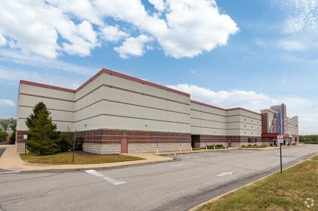
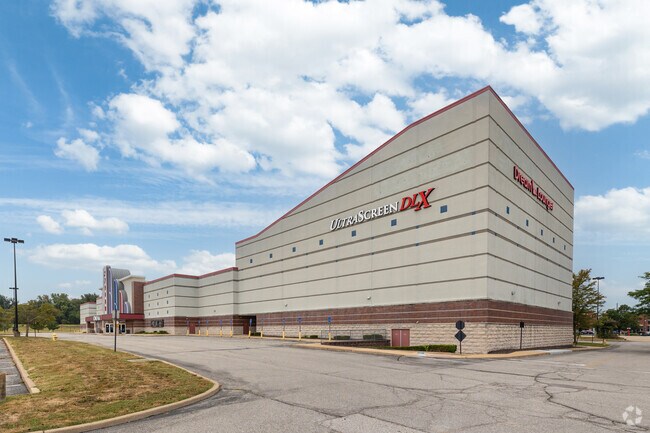
450 Thf Blvd
St. Louis, MO-IL
Chesterfield Commons Four
17U-24-0202
CHESTERFIELD COMMONS FOUR (14986/0185/LEASE) LOT 1
Theater
St. Louis
X
Missouri
29183C0465G
1
2024
8.97 AC
2025
Chesterfield Region
221629
St. Louis
77,721 SF
DEMOGRAPHICS near 450 Thf Blvd
1 mile
3 mile
5 mile
2024 Total Population
1,725
17,521
82,365
2029 Population
1,732
17,317
82,409
Pop Growth 2024-2029
+ 0.41%
(1.16%)
+ 0.05%
Average Age
41
42
44
2024 Total Households
573
6,805
31,027
HH Growth 2024-2029
+ 0.35%
(1.09%)
+ 0.04%
Median Household Inc
$168,611
$157,002
$134,982
Avg Household Size
3.00
2.50
2.60
2024 Avg HH Vehicles
2.00
2.00
2.00
Median Home Value
$568,277
$631,830
$403,184
Median Year Built
1996
1991
1986
Nearby Places
Map Layers
Map Styles
 Street
 Aerial
Transit
 Traffic
 Biking
Places
Listings with unknown addresses are not visible on the map
- Restaurants
- Banks
- Shops
- Fitness
- Groceries
PUBLIC TRANSPORTATION
AIRPORT
St Louis Lambert International
Drive
Walk
Distance
St Louis Lambert International
34 min
24.1 mi
Freight Ports
Tulsa Port of Inola
Drive
Walk
Distance
Tulsa Port of Inola
412 min
368.8 mi
SALE & LEASE HISTORY
LISTING DATE
SALE/LEASE

Dec 02, 2019
For Lease
Nearby Properties
Address
Land Use
TOTAL SIZE
Lot Size
Zoning
Address
Land Use
TOTAL SIZE
Lot Size
Zoning
8.21 AC
105C8
Address
Land Use
TOTAL SIZE
Lot Size
Zoning
1,298,224 SF
194.08 AC
C-8
Address
Land Use
TOTAL SIZE
Lot Size
Zoning
420,140 SF
16.49 AC
105C8
Address
Land Use
TOTAL SIZE
Lot Size
Zoning
462,876 SF
12.89 AC
105R8
Address
Land Use
TOTAL SIZE
Lot Size
Zoning
157,315 SF
41.71 AC
105C8
Address
Land Use
TOTAL SIZE
Lot Size
Zoning
Address
Land Use
TOTAL SIZE
Lot Size
Zoning
352,152 SF
31.79 AC
105C8
Address
Land Use
TOTAL SIZE
Lot Size
Zoning
Address
Land Use
TOTAL SIZE
Lot Size
Zoning
351,496 SF
31.73 AC
NU
Address
Land Use
TOTAL SIZE
Lot Size
Zoning
269,687 SF
38.30 AC
105C8
Address
Land Use
TOTAL SIZE
Lot Size
Zoning
218,130 SF
7.31 AC
105PC&R
Address
Land Use
TOTAL SIZE
Lot Size
Zoning
363,584 SF
48.15 AC
FPNU
Address
Land Use
TOTAL SIZE
Lot Size
Zoning
344,386 SF
41.26 AC
R2
Address
Land Use
TOTAL SIZE
Lot Size
Zoning
359,937 SF
26.91 AC
R4
Address
Land Use
TOTAL SIZE
Lot Size
Zoning
242,380 SF
12.60 AC
105PC&R
Address
Land Use
TOTAL SIZE
Lot Size
Zoning
288,733 SF
36.80 AC
R5
Address
Land Use
TOTAL SIZE
Lot Size
Zoning
182,939 SF
3.80 AC
105PC
Address
Land Use
TOTAL SIZE
Lot Size
Zoning
285,752 SF
23.98 AC
105PC
Address
Land Use
TOTAL SIZE
Lot Size
Zoning
197,927 SF
16.61 AC
105C8
Address
Land Use
TOTAL SIZE
Lot Size
Zoning
204,940 SF
16.35 AC
FPNU
Address
Land Use
TOTAL SIZE
Lot Size
Zoning
2,164 SF
22.98 AC
105PS
Address
Land Use
TOTAL SIZE
Lot Size
Zoning
89,348 SF
2.61 AC
105C8
Address
Land Use
TOTAL SIZE
Lot Size
Zoning
58,710 SF
14.75 AC
105PC
Address
Land Use
TOTAL SIZE
Lot Size
Zoning
117,704 SF
9.27 AC
105PI
Address
Land Use
TOTAL SIZE
Lot Size
Zoning
150,788 SF
4.91 AC
105C8
Address
Land Use
TOTAL SIZE
Lot Size
Zoning
7,860 SF
223.24 AC
105M3
Address
Land Use
TOTAL SIZE
Lot Size
Zoning
84,818 SF
10.11 AC
105M3
Address
Land Use
TOTAL SIZE
Lot Size
Zoning
185.56 AC
105FPNU
Address
Land Use
TOTAL SIZE
Lot Size
Zoning
109,771 SF
11.35 AC
105C8
Address
Land Use
TOTAL SIZE
Lot Size
Zoning
121,583 SF
3.20 AC
105C8
The World's #1 Commercial Real Estate Marketplace
Connect with us
© 2026 CoStar Group
The information above has been obtained from sources believed reliable. While we do not doubt its accuracy we have not verified it and make no guarantee, warranty or representation about it. It is your responsibility to independently confirm its accuracy and completeness. Any projections, opinions, assumptions, or estimates used are for example only and do not represent the current or future performance of the property. The value of this transaction to you depends on tax and other factors which should be evaluated by your tax, financial, and legal advisors. You and your advisors should conduct a careful, independent investigation of the property to determine to your satisfaction the suitability of the property for your needs.