Property Record
450 Thunder Rd, Rutherfordton, NC 28139
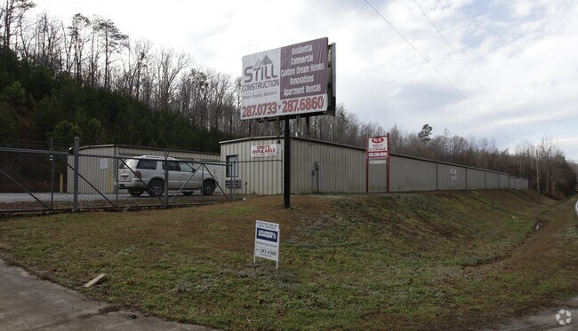

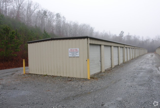
Property Detail
450 Thunder Rd
1628248
RUTHERFORD
Publicstorage
North Carolina
B and X Area of moderate flood hazard, usually the area between the limits of the 100-year and 500-year floods.
3.75 AC
2025
North Carolina West/Cherokee Area
2025
Other Market Areas
960501
Forest City, NC
5,400 SF
NEARBY LISTINGS FOR SALE OR LEASE
-
-
View all Rutherfordton listings for sale on LoopNet.com
DEMOGRAPHICS near 450 Thunder Rd
1 mile
3 mile
5 mile
2025 Total Population
842
11,706
23,298
2030 Population
860
11,873
23,563
Pop Growth 2025-2030
+ 2.14%
+ 1.43%
+ 1.14%
Average Age
44
43
43
2025 Total Households
345
4,856
9,593
HH Growth 2025-2030
+ 2.32%
+ 1.38%
+ 1.08%
Median Household Inc
$38,243
$39,703
$39,802
Avg Household Size
2.40
2.30
2.30
2025 Avg HH Vehicles
2.00
2.00
2.00
Median Home Value
$203,509
$210,899
$207,661
Median Year Built
1976
1974
1974
Nearby Places
Map Layers
Map Styles
 Street
 Aerial
Layers
 Traffic
 Biking
Places
Listings with unknown addresses are not visible on the map
- Restaurants
- Banks
- Shops
- Fitness
- Groceries
Nearby Properties
Address
Land Use
TOTAL SIZE
Lot Size
Zoning
Address
Land Use
TOTAL SIZE
Lot Size
Zoning
168,615 SF
27.34 AC
CIV
Address
Land Use
TOTAL SIZE
Lot Size
Zoning
141,217 SF
27.03 AC
Address
Land Use
TOTAL SIZE
Lot Size
Zoning
204,184 SF
28.30 AC
C3
Address
Land Use
TOTAL SIZE
Lot Size
Zoning
87,123 SF
1.98 AC
Address
Land Use
TOTAL SIZE
Lot Size
Zoning
87,108 SF
26.73 AC
GC
Address
Land Use
TOTAL SIZE
Lot Size
Zoning
61,023 SF
7.64 AC
R6
Address
Land Use
TOTAL SIZE
Lot Size
Zoning
1,408 SF
6.95 AC
R20
Address
Land Use
TOTAL SIZE
Lot Size
Zoning
63,006 SF
14.29 AC
Address
Land Use
TOTAL SIZE
Lot Size
Zoning
328,907 SF
52.37 AC
Address
Land Use
TOTAL SIZE
Lot Size
Zoning
58,300 SF
3.13 AC
C3
Address
Land Use
TOTAL SIZE
Lot Size
Zoning
4,982 SF
27.13 AC
Address
Land Use
TOTAL SIZE
Lot Size
Zoning
2,026 SF
8.71 AC
R6
Address
Land Use
TOTAL SIZE
Lot Size
Zoning
12,480 SF
43 AC
Address
Land Use
TOTAL SIZE
Lot Size
Zoning
95,267 SF
8.40 AC
GC
Address
Land Use
TOTAL SIZE
Lot Size
Zoning
16,074 SF
101.60 AC
Address
Land Use
TOTAL SIZE
Lot Size
Zoning
7,424 SF
6.39 AC
IND
Address
Land Use
TOTAL SIZE
Lot Size
Zoning
53,790 SF
6.37 AC
R6
Address
Land Use
TOTAL SIZE
Lot Size
Zoning
36,693 SF
3.04 AC
C3
Address
Land Use
TOTAL SIZE
Lot Size
Zoning
23,990 SF
3 AC
Address
Land Use
TOTAL SIZE
Lot Size
Zoning
6,448 SF
3.30 AC
GC
Address
Land Use
TOTAL SIZE
Lot Size
Zoning
6,000 SF
15.30 AC
Address
Land Use
TOTAL SIZE
Lot Size
Zoning
6,988 SF
1.51 AC
R6
Address
Land Use
TOTAL SIZE
Lot Size
Zoning
10,366 SF
1.22 AC
CIV
Address
Land Use
TOTAL SIZE
Lot Size
Zoning
19,530 SF
1.50 AC
CIV
Address
Land Use
TOTAL SIZE
Lot Size
Zoning
68,025 SF
14.84 AC
Address
Land Use
TOTAL SIZE
Lot Size
Zoning
34,861 SF
4.38 AC
CIV
Address
Land Use
TOTAL SIZE
Lot Size
Zoning
93,600 SF
45.11 AC
HCI
Address
Land Use
TOTAL SIZE
Lot Size
Zoning
17,622 SF
5.14 AC
MS
Address
Land Use
TOTAL SIZE
Lot Size
Zoning
53,860 SF
15.88 AC
CIV
Address
Land Use
TOTAL SIZE
Lot Size
Zoning
7,367 SF
0.64 AC
CIV
The World's #1 Commercial Real Estate Marketplace
Connect with us
© 2026 CoStar Group
The information above has been obtained from sources believed reliable. While we do not doubt its accuracy we have not verified it and make no guarantee, warranty or representation about it. It is your responsibility to independently confirm its accuracy and completeness. Any projections, opinions, assumptions, or estimates used are for example only and do not represent the current or future performance of the property. The value of this transaction to you depends on tax and other factors which should be evaluated by your tax, financial, and legal advisors. You and your advisors should conduct a careful, independent investigation of the property to determine to your satisfaction the suitability of the property for your needs.