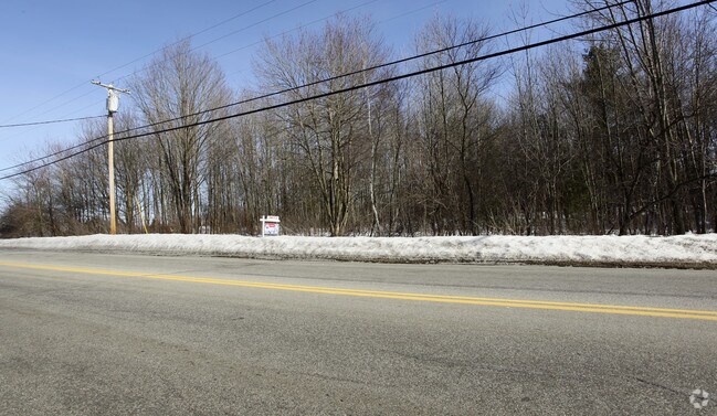
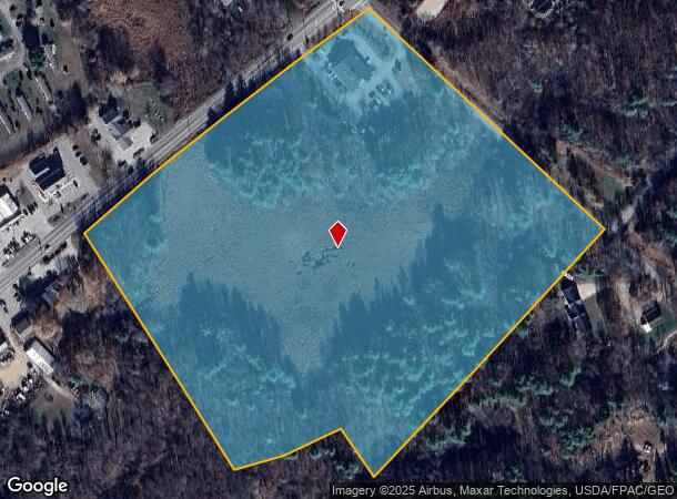
Property Record
450 Us Route 1, Kittery, ME 03904
NEARBY LISTINGS FOR SALE OR LEASE
Property Detail
450 Us Route 1
KITT-000061-000000-000028
York
Departmentstore
Maine
A
28
23031C0727G
19.58 AC
2024
York County
2024
Portland/South Portland
038001
Portland-South Portland, ME
4,712 SF
DEMOGRAPHICS near 450 Us Route 1
1 Mile
3 Mile
5 Mile
2024 Total Population
1,616
13,209
39,710
2029 Population
1,734
13,910
41,707
Pop Growth 2024-2029
+ 7.30%
+ 5.31%
+ 5.03%
Average Age
47
45
45
2024 Total Households
686
5,720
18,015
HH Growth 2024-2029
+ 7.43%
+ 5.26%
+ 4.97%
Median Household Inc
$87,090
$86,547
$95,365
Avg Household Size
2.30
2.20
2.10
2024 Avg HH Vehicles
2.00
2.00
2.00
Median Home Value
$369,892
$419,000
$498,925
Median Year Built
1991
1978
1968
Nearby Places
Map Layers
Map Styles
 Street
 Aerial
- Restaurants
- Banks
- Shops
- Fitness
- Groceries
PUBLIC TRANSPORTATION
AIRPORT
Portsmouth International at Pease
DRIVE
WALK
Distance
Portsmouth International at Pease
16 min
7.0 mi
Freight Ports
Portland, ME
DRIVE
WALK
Distance
Portland, ME
57 min
46.9 mi
SALE & LEASE HISTORY
LISTING DATE
SALE/LEASE

Sep 24, 2016
For Sale
Nearby Properties
Address
Land Use
TOTAL SIZE
Lot Size
Zoning
Address
Land Use
TOTAL SIZE
Lot Size
Zoning
22.33 AC
MU-N
Address
Land Use
TOTAL SIZE
Lot Size
Zoning
3.97 AC
SD
Address
Land Use
TOTAL SIZE
Lot Size
Zoning
84,273 SF
13.61 AC
C-1
Address
Land Use
TOTAL SIZE
Lot Size
Zoning
40,736 SF
14.82 AC
C-1
Address
Land Use
TOTAL SIZE
Lot Size
Zoning
92,943 SF
8.55 AC
C-1
Address
Land Use
TOTAL SIZE
Lot Size
Zoning
88,630 SF
5.50 AC
R-S
Address
Land Use
TOTAL SIZE
Lot Size
Zoning
117,164 SF
5.40 AC
C-3
Address
Land Use
TOTAL SIZE
Lot Size
Zoning
0.10 AC
C-3
Address
Land Use
TOTAL SIZE
Lot Size
Zoning
1,248 SF
6.48 AC
R1-2
Address
Land Use
TOTAL SIZE
Lot Size
Zoning
47,573 SF
1.96 AC
C-1
Address
Land Use
TOTAL SIZE
Lot Size
Zoning
46,468 SF
14.53 AC
R-RL
Address
Land Use
TOTAL SIZE
Lot Size
Zoning
6,160 SF
3.25 AC
C-1
Address
Land Use
TOTAL SIZE
Lot Size
Zoning
12,348 SF
13.56 AC
MU
Address
Land Use
TOTAL SIZE
Lot Size
Zoning
30,698 SF
8.25 AC
C-3
Address
Land Use
TOTAL SIZE
Lot Size
Zoning
44,716 SF
39.05 AC
R-U
Address
Land Use
TOTAL SIZE
Lot Size
Zoning
140,986 SF
7.25 AC
R-U
Address
Land Use
TOTAL SIZE
Lot Size
Zoning
30 AC
R1-1
Address
Land Use
TOTAL SIZE
Lot Size
Zoning
0.40 AC
R-KPV
Address
Land Use
TOTAL SIZE
Lot Size
Zoning
113,353 SF
28 AC
MU
Address
Land Use
TOTAL SIZE
Lot Size
Zoning
39,530 SF
12.49 AC
R-U
Address
Land Use
TOTAL SIZE
Lot Size
Zoning
30,240 SF
5.60 AC
C-1
Address
Land Use
TOTAL SIZE
Lot Size
Zoning
22,620 SF
4.69 AC
C-1
Address
Land Use
TOTAL SIZE
Lot Size
Zoning
13,020 SF
7 AC
C-1
Address
Land Use
TOTAL SIZE
Lot Size
Zoning
22,653 SF
2.90 AC
C-1
Address
Land Use
TOTAL SIZE
Lot Size
Zoning
1,800 SF
5.76 AC
C/I
Address
Land Use
TOTAL SIZE
Lot Size
Zoning
19,066 SF
3.60 AC
C-1
Address
Land Use
TOTAL SIZE
Lot Size
Zoning
2,900 SF
19.53 AC
MU
Address
Land Use
TOTAL SIZE
Lot Size
Zoning
28,688 SF
2.15 AC
R1-3
Address
Land Use
TOTAL SIZE
Lot Size
Zoning
15,862 SF
7 AC
C-1
Address
Land Use
TOTAL SIZE
Lot Size
Zoning
72,765 SF
2.80 AC
C-2
The World's #1 Commercial Real Estate Marketplace
Connect with us
© 2025 CoStar Group
The information above has been obtained from sources believed reliable. While we do not doubt its accuracy we have not verified it and make no guarantee, warranty or representation about it. It is your responsibility to independently confirm its accuracy and completeness. Any projections, opinions, assumptions, or estimates used are for example only and do not represent the current or future performance of the property. The value of this transaction to you depends on tax and other factors which should be evaluated by your tax, financial, and legal advisors. You and your advisors should conduct a careful, independent investigation of the property to determine to your satisfaction the suitability of the property for your needs.