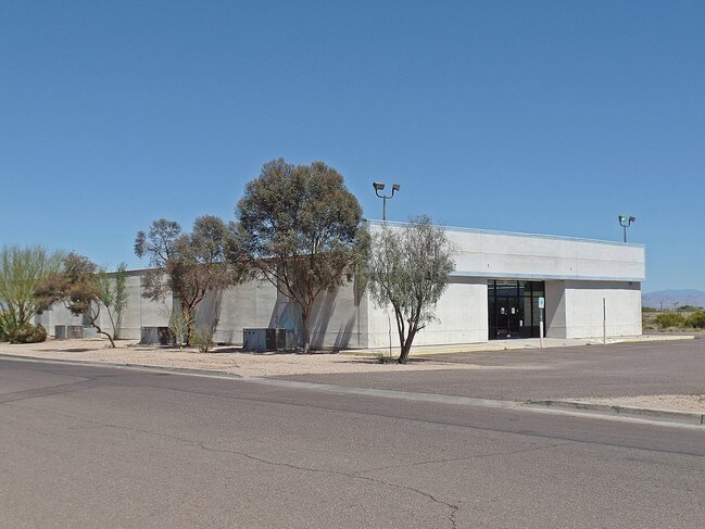
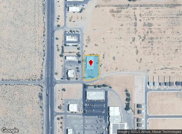
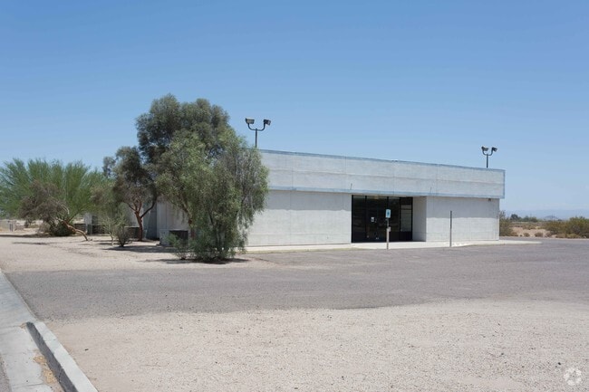
Property Record
450 W Ruins Dr, Coolidge, AZ 85128

NEARBY LISTINGS FOR SALE OR LEASE
Property Detail
450 W Ruins Dr
Phoenix-Mesa-Chandler, AZ
Coolidge Gate
203-13-015
REPLAT OF COOLIDGE GATEWAY SEC 15-5S-8E LOT 4 1.02 AC 44476 SQ FT
Gymhealthspa
Pinal
X
Arizona
04021C1225E
4
2024
1.02 AC
2025
Outlying Pinal County
001000
Phoenix
9,020 SF
DEMOGRAPHICS near 450 W Ruins Dr
1 Mile
3 Mile
5 Mile
2024 Total Population
3,512
16,891
20,546
2029 Population
4,434
21,648
26,336
Pop Growth 2024-2029
+ 26.25%
+ 28.16%
+ 28.18%
Average Age
38
36
37
2024 Total Households
1,220
5,559
6,741
HH Growth 2024-2029
+ 25.90%
+ 27.83%
+ 27.93%
Median Household Inc
$47,333
$57,942
$63,858
Avg Household Size
2.90
3.00
3.00
2024 Avg HH Vehicles
2.00
2.00
2.00
Median Home Value
$121,208
$131,788
$157,129
Median Year Built
1978
2001
2003
Nearby Places
Map Layers
Map Styles
 Street
 Aerial
- Restaurants
- Banks
- Shops
- Fitness
- Groceries
PUBLIC TRANSPORTATION
AIRPORT
Phoenix-Mesa Gateway
DRIVE
WALK
Distance
Phoenix-Mesa Gateway
50 min
30.0 mi
SALE & LEASE HISTORY
LISTING DATE
SALE/LEASE

Sep 24, 2016
For Lease
Sep 23, 2016
For Sale
Nearby Properties
Address
Land Use
TOTAL SIZE
Lot Size
Zoning
Address
Land Use
TOTAL SIZE
Lot Size
Zoning
101.31 AC
UNDESIGNAT
Address
Land Use
TOTAL SIZE
Lot Size
Zoning
Address
Land Use
TOTAL SIZE
Lot Size
Zoning
108,984 SF
9.26 AC
UNDESIGNAT
Address
Land Use
TOTAL SIZE
Lot Size
Zoning
15.02 AC
Address
Land Use
TOTAL SIZE
Lot Size
Zoning
12.33 AC
UNDESIGNAT
Address
Land Use
TOTAL SIZE
Lot Size
Zoning
82,162 SF
7.98 AC
Address
Land Use
TOTAL SIZE
Lot Size
Zoning
111,159 SF
18.51 AC
UNDESIGNAT
Address
Land Use
TOTAL SIZE
Lot Size
Zoning
28,136 SF
9.38 AC
Address
Land Use
TOTAL SIZE
Lot Size
Zoning
48,140 SF
6.37 AC
UNDESIGNAT
Address
Land Use
TOTAL SIZE
Lot Size
Zoning
1,356 SF
10.89 AC
Address
Land Use
TOTAL SIZE
Lot Size
Zoning
51,762 SF
7.44 AC
Address
Land Use
TOTAL SIZE
Lot Size
Zoning
35,275 SF
3.59 AC
UNDESIGNAT
Address
Land Use
TOTAL SIZE
Lot Size
Zoning
34,072 SF
2.70 AC
Address
Land Use
TOTAL SIZE
Lot Size
Zoning
38,400 SF
4.36 AC
Address
Land Use
TOTAL SIZE
Lot Size
Zoning
46,380 SF
0.97 AC
GR
Address
Land Use
TOTAL SIZE
Lot Size
Zoning
54,530 SF
5 AC
Address
Land Use
TOTAL SIZE
Lot Size
Zoning
28,160 SF
2.63 AC
UNDESIGNAT
Address
Land Use
TOTAL SIZE
Lot Size
Zoning
290 SF
17.50 AC
UNDESIGNAT
Address
Land Use
TOTAL SIZE
Lot Size
Zoning
2,982 SF
17.11 AC
GR
Address
Land Use
TOTAL SIZE
Lot Size
Zoning
24,956 SF
2.22 AC
UNDESIGNAT
Address
Land Use
TOTAL SIZE
Lot Size
Zoning
15,620 SF
0.77 AC
Address
Land Use
TOTAL SIZE
Lot Size
Zoning
14,736 SF
1.53 AC
Address
Land Use
TOTAL SIZE
Lot Size
Zoning
17,720 SF
2.39 AC
Address
Land Use
TOTAL SIZE
Lot Size
Zoning
16,190 SF
4.81 AC
Address
Land Use
TOTAL SIZE
Lot Size
Zoning
Address
Land Use
TOTAL SIZE
Lot Size
Zoning
35,624 SF
2.84 AC
Address
Land Use
TOTAL SIZE
Lot Size
Zoning
0.84 AC
UNDESIGNAT
Address
Land Use
TOTAL SIZE
Lot Size
Zoning
5,900 SF
0.57 AC
The World's #1 Commercial Real Estate Marketplace
Connect with us
© 2026 CoStar Group
The information above has been obtained from sources believed reliable. While we do not doubt its accuracy we have not verified it and make no guarantee, warranty or representation about it. It is your responsibility to independently confirm its accuracy and completeness. Any projections, opinions, assumptions, or estimates used are for example only and do not represent the current or future performance of the property. The value of this transaction to you depends on tax and other factors which should be evaluated by your tax, financial, and legal advisors. You and your advisors should conduct a careful, independent investigation of the property to determine to your satisfaction the suitability of the property for your needs.