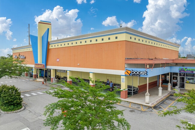
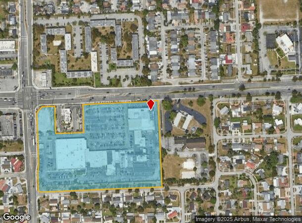
Property Record
4500 Nw 183Rd St, Miami Gardens, FL 33055

NEARBY LISTINGS FOR SALE OR LEASE
Property Detail
4500 Nw 183Rd St
Miami-Miami Beach-Kendall, FL
Miami Gardens S P
34-2108-004-0040
MIAMI GARDENS S P PB 178-003 T-24365 TR A LOT SIZE 488416 SQ FT M/L FAU 34-2108-004-0040
Regionalshoppingcenterormallwithanchorstore
Miami/Dade
AE
Florida
12011C0710J
15
2024
11.21 AC
2025
Miami Gardens/Opa Locka
010022
South Florida
134,472 SF
DEMOGRAPHICS near 4500 Nw 183Rd St
1 Mile
3 Mile
5 Mile
2024 Total Population
21,954
149,695
443,505
2029 Population
21,064
145,385
432,851
Pop Growth 2024-2029
(4.05%)
(2.88%)
(2.40%)
Average Age
41
39
40
2024 Total Households
6,155
47,886
144,072
HH Growth 2024-2029
(4.57%)
(3.17%)
(2.73%)
Median Household Inc
$50,947
$55,736
$58,927
Avg Household Size
3.30
3.00
3.00
2024 Avg HH Vehicles
2.00
2.00
2.00
Median Home Value
$309,571
$288,668
$322,162
Median Year Built
1969
1979
1980
Nearby Places
Map Layers
Map Styles
 Street
 Aerial
- Restaurants
- Banks
- Shops
- Fitness
- Groceries
PUBLIC TRANSPORTATION
COMMUTER RAIL
Opa-Locka (Tri-County Commuter - South Florida Regional Transportation Authority (Tri-Rail))
DRIVE
WALK
Distance
Opa-Locka (Tri-County Commuter - South Florida Regional Transportation Authority (Tri-Rail))
8 min
4.2 mi
Golden Glades (Tri-County Commuter - South Florida Regional Transportation Authority (Tri-Rail))
DRIVE
WALK
Distance
Golden Glades (Tri-County Commuter - South Florida Regional Transportation Authority (Tri-Rail))
11 min
6.7 mi
AIRPORT
Miami International
DRIVE
WALK
Distance
Miami International
27 min
15.5 mi
Fort Lauderdale/Hollywood International
DRIVE
WALK
Distance
Fort Lauderdale/Hollywood International
26 min
16.2 mi
Freight Ports
Port of Miami
DRIVE
WALK
Distance
Port of Miami
29 min
17.6 mi
SALE & LEASE HISTORY
LISTING DATE
SALE/LEASE

Sep 25, 2016
For Lease
Sep 22, 2025
For Lease
Feb 28, 2017
For Lease
Feb 09, 2024
For Lease
Aug 31, 2021
For Sale
Nearby Properties
Address
Land Use
TOTAL SIZE
Lot Size
Zoning
Address
Land Use
TOTAL SIZE
Lot Size
Zoning
189,131 SF
115.71 AC
9000
Address
Land Use
TOTAL SIZE
Lot Size
Zoning
2,129,231 SF
6500
Address
Land Use
TOTAL SIZE
Lot Size
Zoning
1,837,228 SF
498.34 AC
8500
Address
Land Use
TOTAL SIZE
Lot Size
Zoning
1,589,724 SF
95.63 AC
7100
Address
Land Use
TOTAL SIZE
Lot Size
Zoning
436,707 SF
32.94 AC
RM3
Address
Land Use
TOTAL SIZE
Lot Size
Zoning
426,620 SF
17.69 AC
RM3
Address
Land Use
TOTAL SIZE
Lot Size
Zoning
359,351 SF
28.25 AC
RM3
Address
Land Use
TOTAL SIZE
Lot Size
Zoning
446,522 SF
13.14 AC
9450
Address
Land Use
TOTAL SIZE
Lot Size
Zoning
649,901 SF
124.04 AC
9400
Address
Land Use
TOTAL SIZE
Lot Size
Zoning
696,550 SF
2.97 AC
6109
Address
Land Use
TOTAL SIZE
Lot Size
Zoning
1,165,101 SF
115.84 AC
8000
Address
Land Use
TOTAL SIZE
Lot Size
Zoning
110,869 SF
155.94 AC
RL
Address
Land Use
TOTAL SIZE
Lot Size
Zoning
428,838 SF
32.81 AC
6500
Address
Land Use
TOTAL SIZE
Lot Size
Zoning
420,332 SF
9.71 AC
6500
Address
Land Use
TOTAL SIZE
Lot Size
Zoning
355,120 SF
18 AC
5000
Address
Land Use
TOTAL SIZE
Lot Size
Zoning
331,131 SF
12.09 AC
3900
Address
Land Use
TOTAL SIZE
Lot Size
Zoning
370,044 SF
17.86 AC
6051
Address
Land Use
TOTAL SIZE
Lot Size
Zoning
315,033 SF
11.48 AC
6109
Address
Land Use
TOTAL SIZE
Lot Size
Zoning
866,013 SF
0.11 AC
8000
Address
Land Use
TOTAL SIZE
Lot Size
Zoning
324,751 SF
36.80 AC
CF
Address
Land Use
TOTAL SIZE
Lot Size
Zoning
432,595 SF
22.60 AC
PID
Address
Land Use
TOTAL SIZE
Lot Size
Zoning
536,184 SF
29.16 AC
7100
Address
Land Use
TOTAL SIZE
Lot Size
Zoning
552,632 SF
6.05 AC
4100
Address
Land Use
TOTAL SIZE
Lot Size
Zoning
189,293 SF
6.08 AC
RM3
Address
Land Use
TOTAL SIZE
Lot Size
Zoning
389,450 SF
50.72 AC
9400
Address
Land Use
TOTAL SIZE
Lot Size
Zoning
279,588 SF
42.06 AC
8600
Address
Land Use
TOTAL SIZE
Lot Size
Zoning
468,316 SF
13.20 AC
4100
Address
Land Use
TOTAL SIZE
Lot Size
Zoning
286,547 SF
9.47 AC
6109
Address
Land Use
TOTAL SIZE
Lot Size
Zoning
167,427 SF
6.85 AC
3900
Address
Land Use
TOTAL SIZE
Lot Size
Zoning
68,227 SF
388.62 AC
8000
The World's #1 Commercial Real Estate Marketplace
Connect with us
© 2026 CoStar Group
The information above has been obtained from sources believed reliable. While we do not doubt its accuracy we have not verified it and make no guarantee, warranty or representation about it. It is your responsibility to independently confirm its accuracy and completeness. Any projections, opinions, assumptions, or estimates used are for example only and do not represent the current or future performance of the property. The value of this transaction to you depends on tax and other factors which should be evaluated by your tax, financial, and legal advisors. You and your advisors should conduct a careful, independent investigation of the property to determine to your satisfaction the suitability of the property for your needs.