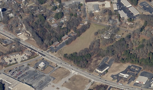
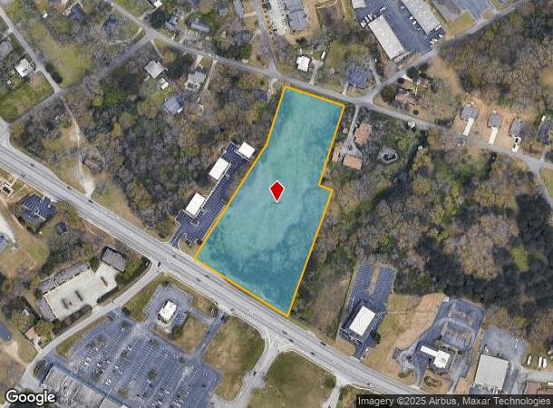
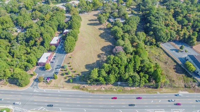
Property Record
Atlanta Hwy, Loganville, GA 30052
NEARBY LISTINGS FOR SALE OR LEASE
-
-
-
-
-
-
-
No Photo
-
View all Loganville listings for sale on LoopNet.com
Property Detail
Atlanta Hwy
Atlanta-Sandy Springs-Roswell, GA
TR#1 5.02AC
LG06000000129000
Walton
Residentialacreage
Georgia
X
0
13297C0085E
5.02 AC
2024
Walton County
2024
Atlanta
110509
DEMOGRAPHICS near Atlanta Hwy
1 Mile
3 Mile
5 Mile
2024 Total Population
6,286
34,247
84,316
2029 Population
7,162
37,787
91,862
Pop Growth 2024-2029
+ 13.94%
+ 10.34%
+ 8.95%
Average Age
39
38
38
2024 Total Households
2,185
11,044
26,924
HH Growth 2024-2029
+ 14.23%
+ 10.69%
+ 9.26%
Median Household Inc
$77,054
$85,769
$87,091
Avg Household Size
2.80
3.10
3.10
2024 Avg HH Vehicles
2.00
2.00
2.00
Median Home Value
$256,602
$280,412
$288,233
Median Year Built
1996
2001
2001
Nearby Places
- Restaurants
- Banks
- Shops
- Fitness
- Groceries
SALE & LEASE HISTORY
LISTING DATE
SALE/LEASE

Sep 24, 2016
For Sale
Oct 11, 2019
For Sale
Mar 16, 2017
For Sale
Nearby Properties
Address
Land Use
TOTAL SIZE
Lot Size
Zoning
Address
Land Use
TOTAL SIZE
Lot Size
Zoning
455,030 SF
80.40 AC
R100
Address
Land Use
TOTAL SIZE
Lot Size
Zoning
189,254 SF
40 AC
R100
Address
Land Use
TOTAL SIZE
Lot Size
Zoning
197,044 SF
95.31 AC
A1
Address
Land Use
TOTAL SIZE
Lot Size
Zoning
133,375 SF
16.50 AC
CH
Address
Land Use
TOTAL SIZE
Lot Size
Zoning
3,480 SF
57.72 AC
RM8
Address
Land Use
TOTAL SIZE
Lot Size
Zoning
3,261 SF
30 AC
RM8
Address
Land Use
TOTAL SIZE
Lot Size
Zoning
111,277 SF
17.36 AC
CH
Address
Land Use
TOTAL SIZE
Lot Size
Zoning
82,809 SF
21.79 AC
R100
Address
Land Use
TOTAL SIZE
Lot Size
Zoning
154,281 SF
45.25 AC
R44
Address
Land Use
TOTAL SIZE
Lot Size
Zoning
103,892 SF
17.44 AC
CH
Address
Land Use
TOTAL SIZE
Lot Size
Zoning
79,276 SF
9.08 AC
C2
Address
Land Use
TOTAL SIZE
Lot Size
Zoning
56,664 SF
5.35 AC
CH
Address
Land Use
TOTAL SIZE
Lot Size
Zoning
102,850 SF
10.03 AC
LI
Address
Land Use
TOTAL SIZE
Lot Size
Zoning
29,724 SF
24.45 AC
R100
Address
Land Use
TOTAL SIZE
Lot Size
Zoning
105,840 SF
2.66 AC
C2
Address
Land Use
TOTAL SIZE
Lot Size
Zoning
201,210 SF
27.11 AC
CH
Address
Land Use
TOTAL SIZE
Lot Size
Zoning
137,401 SF
12.95 AC
CH
Address
Land Use
TOTAL SIZE
Lot Size
Zoning
34,130 SF
7.80 AC
R100
Address
Land Use
TOTAL SIZE
Lot Size
Zoning
14,784 SF
90.18 AC
R100
Address
Land Use
TOTAL SIZE
Lot Size
Zoning
118,235 SF
31.54 AC
CH
Address
Land Use
TOTAL SIZE
Lot Size
Zoning
83,131 SF
3.44 AC
LI
Address
Land Use
TOTAL SIZE
Lot Size
Zoning
40,359 SF
5.51 AC
CH
Address
Land Use
TOTAL SIZE
Lot Size
Zoning
51,764 SF
9 AC
R44
Address
Land Use
TOTAL SIZE
Lot Size
Zoning
74,945 SF
12.99 AC
CH
Address
Land Use
TOTAL SIZE
Lot Size
Zoning
205,621 SF
14.49 AC
CH
Address
Land Use
TOTAL SIZE
Lot Size
Zoning
25,781 SF
5.36 AC
CH
Address
Land Use
TOTAL SIZE
Lot Size
Zoning
30,999 SF
2.96 AC
CH
Address
Land Use
TOTAL SIZE
Lot Size
Zoning
62,352 SF
22.67 AC
CH
Address
Land Use
TOTAL SIZE
Lot Size
Zoning
37,762 SF
4.19 AC
C2
Address
Land Use
TOTAL SIZE
Lot Size
Zoning
44,136 SF
8.14 AC
C2
The World's #1 Commercial Real Estate Marketplace
Connect with us
© 2025 CoStar Group
The information above has been obtained from sources believed reliable. While we do not doubt its accuracy we have not verified it and make no guarantee, warranty or representation about it. It is your responsibility to independently confirm its accuracy and completeness. Any projections, opinions, assumptions, or estimates used are for example only and do not represent the current or future performance of the property. The value of this transaction to you depends on tax and other factors which should be evaluated by your tax, financial, and legal advisors. You and your advisors should conduct a careful, independent investigation of the property to determine to your satisfaction the suitability of the property for your needs.