Property Record
4500 Lemay Ferry Rd, Saint Louis, MO 63129


Property Detail
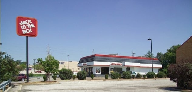
4500 Lemay Ferry Rd
29K-32-2206
MARYALAN ACRES AMENDED ADDITION NO 1 LOT 18 & KELLER ESTATES LOT 17 & SEC 3-43-6 BDY ADJ PARCEL C RD DEDI & ESMT PLAT PARCEL PT 3 10 12 89
Restaurantbuilding
Saint Louis
C-8
Missouri
B and X Area of moderate flood hazard, usually the area between the limits of the 100-year and 500-year floods.
18,17
2024
0.64 AC
2025
Southwest County
220447
St. Louis
2,298 SF
St. Louis, MO-IL
NEARBY LISTINGS FOR SALE OR LEASE
DEMOGRAPHICS near 4500 Lemay Ferry Rd
1 mile
3 mile
5 mile
2025 Total Population
11,216
85,991
178,701
2030 Population
11,146
84,648
176,225
Pop Growth 2025-2030
(0.62%)
(1.56%)
(1.39%)
Average Age
44
44
43
2025 Total Households
5,151
37,415
76,405
HH Growth 2025-2030
(0.74%)
(1.59%)
(1.42%)
Median Household Inc
$73,257
$79,622
$81,644
Avg Household Size
2.10
2.30
2.30
2025 Avg HH Vehicles
2.00
2.00
2.00
Median Home Value
$282,914
$263,751
$256,330
Median Year Built
1979
1971
1968
Nearby Places
Map Layers
Map Styles
 Street
 Aerial
Layers
 Traffic
 Biking
Places
Listings with unknown addresses are not visible on the map
- Restaurants
- Banks
- Shops
- Fitness
- Groceries
PUBLIC TRANSPORTATION
COMMUTER RAIL
Shrewsbury-Lansdowne (Shrewsbury-Lansdowne I-44 Emerson Park - St. Louis MetroLink (MetroLink))
Drive
Walk
Distance
Shrewsbury-Lansdowne (Shrewsbury-Lansdowne I-44 Emerson Park - St. Louis MetroLink (MetroLink))
18 min
8.7 mi
Sunnen (Shrewsbury-Lansdowne I-44 Emerson Park - St. Louis MetroLink (MetroLink))
Drive
Walk
Distance
Sunnen (Shrewsbury-Lansdowne I-44 Emerson Park - St. Louis MetroLink (MetroLink))
20 min
9.3 mi
AIRPORT
St Louis Lambert International
Drive
Walk
Distance
St Louis Lambert International
38 min
21.4 mi
Scott AFB/Midamerica St Louis
Drive
Walk
Distance
Scott AFB/Midamerica St Louis
54 min
37.8 mi
SALE & LEASE HISTORY
LISTING DATE
SALE/LEASE

Feb 16, 2024
For Sale
Aug 30, 2024
For Lease
Nearby Properties
Address
Land Use
TOTAL SIZE
Lot Size
Zoning
Address
Land Use
TOTAL SIZE
Lot Size
Zoning
31.45 AC
Address
Land Use
TOTAL SIZE
Lot Size
Zoning
160,931 SF
141.53 AC
NU
Address
Land Use
TOTAL SIZE
Lot Size
Zoning
31.42 AC
R2
Address
Land Use
TOTAL SIZE
Lot Size
Zoning
93,822 SF
33.97 AC
C-8
Address
Land Use
TOTAL SIZE
Lot Size
Zoning
739,781 SF
22.08 AC
C3
Address
Land Use
TOTAL SIZE
Lot Size
Zoning
391,268 SF
132.29 AC
R4
Address
Land Use
TOTAL SIZE
Lot Size
Zoning
31.25 AC
R2
Address
Land Use
TOTAL SIZE
Lot Size
Zoning
40.60 AC
R4
Address
Land Use
TOTAL SIZE
Lot Size
Zoning
225,758 SF
16.85 AC
R4
Address
Land Use
TOTAL SIZE
Lot Size
Zoning
140,783 SF
15.51 AC
C-8
Address
Land Use
TOTAL SIZE
Lot Size
Zoning
90,185 SF
407.16 AC
P5
Address
Land Use
TOTAL SIZE
Lot Size
Zoning
342,288 SF
19.97 AC
R7
Address
Land Use
TOTAL SIZE
Lot Size
Zoning
26.62 AC
R3
Address
Land Use
TOTAL SIZE
Lot Size
Zoning
113,971 SF
6.64 AC
C-8
Address
Land Use
TOTAL SIZE
Lot Size
Zoning
103,204 SF
1.47 AC
C-8
Address
Land Use
TOTAL SIZE
Lot Size
Zoning
117,399 SF
0.81 AC
Address
Land Use
TOTAL SIZE
Lot Size
Zoning
237,114 SF
18.12 AC
M1
Address
Land Use
TOTAL SIZE
Lot Size
Zoning
142,800 SF
13.38 AC
106PL1
Address
Land Use
TOTAL SIZE
Lot Size
Zoning
216,121 SF
20.04 AC
C-8
Address
Land Use
TOTAL SIZE
Lot Size
Zoning
21.55 AC
C-8
Address
Land Use
TOTAL SIZE
Lot Size
Zoning
386,377 SF
21.34 AC
R7
Address
Land Use
TOTAL SIZE
Lot Size
Zoning
150,982 SF
18.74 AC
C-8
Address
Land Use
TOTAL SIZE
Lot Size
Zoning
2,369 SF
10.70 AC
R4
Address
Land Use
TOTAL SIZE
Lot Size
Zoning
1,800 SF
116.73 AC
PS
Address
Land Use
TOTAL SIZE
Lot Size
Zoning
163,144 SF
14.14 AC
C-8
Address
Land Use
TOTAL SIZE
Lot Size
Zoning
185,035 SF
8.94 AC
106PL1
Address
Land Use
TOTAL SIZE
Lot Size
Zoning
98,008 SF
10.19 AC
C-8
Address
Land Use
TOTAL SIZE
Lot Size
Zoning
499,003 SF
99.34 AC
C-8
Address
Land Use
TOTAL SIZE
Lot Size
Zoning
114,707 SF
10.94 AC
C-8
Address
Land Use
TOTAL SIZE
Lot Size
Zoning
1,268 SF
19.85 AC
R2
The World's #1 Commercial Real Estate Marketplace
Connect with us
© 2026 CoStar Group
The information above has been obtained from sources believed reliable. While we do not doubt its accuracy we have not verified it and make no guarantee, warranty or representation about it. It is your responsibility to independently confirm its accuracy and completeness. Any projections, opinions, assumptions, or estimates used are for example only and do not represent the current or future performance of the property. The value of this transaction to you depends on tax and other factors which should be evaluated by your tax, financial, and legal advisors. You and your advisors should conduct a careful, independent investigation of the property to determine to your satisfaction the suitability of the property for your needs.