No Photo
Property Record
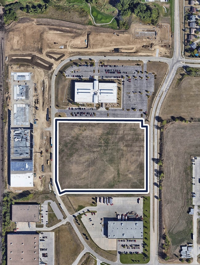
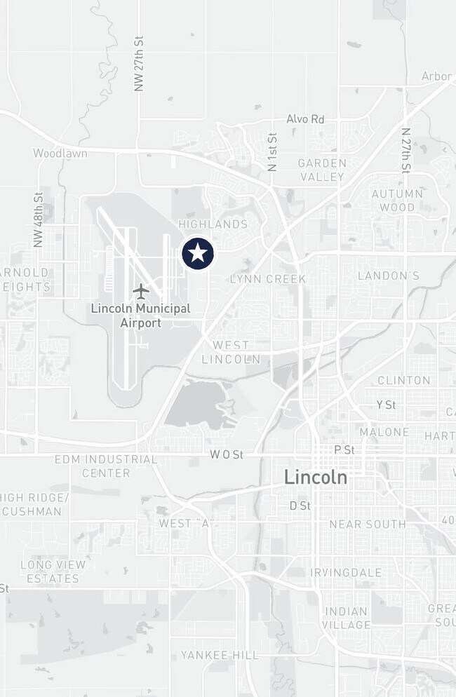
4500 Nw 14Th St, Lincoln, NE 68521

NEARBY LISTINGS FOR SALE OR LEASE
-
-
No Photo
-
-
View all Lincoln listings for sale on LoopNet.com
Property Detail
4500 Nw 14Th St
Lincoln, NE
Highlands Business Park 4Th Addition
11-09-204-002-000
HIGHLANDS BUSINESS PARK 4TH ADDITION, LOT 2
Commercialacreage
Lancaster
X
Nebraska
31109C0305F
2
2024
13.69 AC
2025
North Central
003002
Lincoln
DEMOGRAPHICS near 4500 Nw 14Th St
1 Mile
3 Mile
5 Mile
2024 Total Population
4,592
52,458
128,894
2029 Population
4,721
54,425
133,853
Pop Growth 2024-2029
+ 2.81%
+ 3.75%
+ 3.85%
Average Age
35
34
34
2024 Total Households
1,659
18,887
50,603
HH Growth 2024-2029
+ 2.89%
+ 3.91%
+ 4.18%
Median Household Inc
$82,285
$59,033
$48,553
Avg Household Size
2.70
2.50
2.30
2024 Avg HH Vehicles
2.00
2.00
2.00
Median Home Value
$238,609
$212,025
$186,983
Median Year Built
1994
1994
1980
Nearby Places
Map Layers
Map Styles
 Street
 Aerial
- Restaurants
- Banks
- Shops
- Fitness
- Groceries
PUBLIC TRANSPORTATION
COMMUTER RAIL
Lincoln Amtrak Station (California Zephyr - Amtrak)
DRIVE
WALK
Distance
Lincoln Amtrak Station (California Zephyr - Amtrak)
9 min
4.9 mi
AIRPORT
Lincoln
DRIVE
WALK
Distance
Lincoln
6 min
2.3 mi
Freight Ports
Tulsa Port Of Catoosa
DRIVE
WALK
Distance
Tulsa Port Of Catoosa
477 min
401.4 mi
SALE & LEASE HISTORY
LISTING DATE
SALE/LEASE

May 20, 2024
For Sale
Nearby Properties
Address
Land Use
TOTAL SIZE
Lot Size
Zoning
Address
Land Use
TOTAL SIZE
Lot Size
Zoning
30,018 SF
100.37 AC
R3
Address
Land Use
TOTAL SIZE
Lot Size
Zoning
35,233 SF
28.52 AC
NULL
Address
Land Use
TOTAL SIZE
Lot Size
Zoning
708,074 SF
66.04 AC
I1
Address
Land Use
TOTAL SIZE
Lot Size
Zoning
190,000 SF
158.97 AC
I1
Address
Land Use
TOTAL SIZE
Lot Size
Zoning
35,422 SF
10.79 AC
R3
Address
Land Use
TOTAL SIZE
Lot Size
Zoning
56,867 SF
22.10 AC
NULL
Address
Land Use
TOTAL SIZE
Lot Size
Zoning
32,110 SF
9.64 AC
B2
Address
Land Use
TOTAL SIZE
Lot Size
Zoning
22,552 SF
16.68 AC
NULL
Address
Land Use
TOTAL SIZE
Lot Size
Zoning
523.53 AC
I1
Address
Land Use
TOTAL SIZE
Lot Size
Zoning
141,120 SF
21 AC
O3
Address
Land Use
TOTAL SIZE
Lot Size
Zoning
63,003 SF
1.22 AC
O3
Address
Land Use
TOTAL SIZE
Lot Size
Zoning
228,960 SF
11.04 AC
I2
Address
Land Use
TOTAL SIZE
Lot Size
Zoning
317,607 SF
20.81 AC
I2
Address
Land Use
TOTAL SIZE
Lot Size
Zoning
51,994 SF
4.64 AC
O3
Address
Land Use
TOTAL SIZE
Lot Size
Zoning
405,207 SF
29.97 AC
I2
Address
Land Use
TOTAL SIZE
Lot Size
Zoning
72,775 SF
12.16 AC
I2
Address
Land Use
TOTAL SIZE
Lot Size
Zoning
33,730 SF
6.88 AC
NULL
Address
Land Use
TOTAL SIZE
Lot Size
Zoning
283,600 SF
46.07 AC
I2
Address
Land Use
TOTAL SIZE
Lot Size
Zoning
152,292 SF
20.28 AC
O3
Address
Land Use
TOTAL SIZE
Lot Size
Zoning
111,645 SF
2.32 AC
R8
Address
Land Use
TOTAL SIZE
Lot Size
Zoning
25,620 SF
6.87 AC
NULL
Address
Land Use
TOTAL SIZE
Lot Size
Zoning
234,701 SF
29.39 AC
I1
Address
Land Use
TOTAL SIZE
Lot Size
Zoning
60,678 SF
3.64 AC
I1
Address
Land Use
TOTAL SIZE
Lot Size
Zoning
53,234 SF
5.01 AC
B2
Address
Land Use
TOTAL SIZE
Lot Size
Zoning
73,010 SF
9.67 AC
R3
Address
Land Use
TOTAL SIZE
Lot Size
Zoning
30,555 SF
8.09 AC
NULL
Address
Land Use
TOTAL SIZE
Lot Size
Zoning
2,077,879 SF
219.88 AC
I2
Address
Land Use
TOTAL SIZE
Lot Size
Zoning
87,326 SF
5.53 AC
I3
Address
Land Use
TOTAL SIZE
Lot Size
Zoning
114.02 AC
P
The World's #1 Commercial Real Estate Marketplace
Connect with us
© 2025 CoStar Group
The information above has been obtained from sources believed reliable. While we do not doubt its accuracy we have not verified it and make no guarantee, warranty or representation about it. It is your responsibility to independently confirm its accuracy and completeness. Any projections, opinions, assumptions, or estimates used are for example only and do not represent the current or future performance of the property. The value of this transaction to you depends on tax and other factors which should be evaluated by your tax, financial, and legal advisors. You and your advisors should conduct a careful, independent investigation of the property to determine to your satisfaction the suitability of the property for your needs.