Property Record
4500 River Rd, Riverdale, MD 20737
Current Lease Availabilities
NEARBY LISTINGS FOR SALE OR LEASE
Property Detail
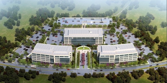
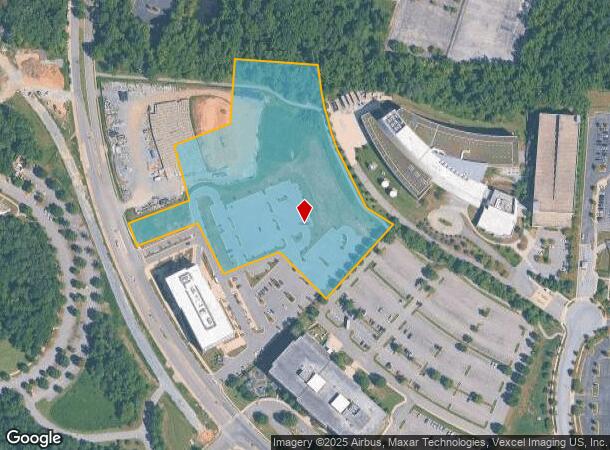
4500 River Rd
Washington-Arlington-Alexandria, DC-VA-MD-WV
RIVERSIDE
21-3733805
Prince George's
Commercialnec
Maryland
X
4
24033C0131E
6.66 AC
2023
College Park
2025
Washington, DC
806602
DEMOGRAPHICS near 4500 River Rd
1 Mile
3 Mile
5 Mile
2024 Total Population
18,101
184,955
446,509
2029 Population
17,893
180,424
431,475
Pop Growth 2024-2029
(1.15%)
(2.45%)
(3.37%)
Average Age
31
35
37
2024 Total Households
4,411
57,593
149,461
HH Growth 2024-2029
(0.82%)
(2.58%)
(3.81%)
Median Household Inc
$80,303
$73,672
$74,286
Avg Household Size
3.00
2.90
2.80
2024 Avg HH Vehicles
2.00
2.00
2.00
Median Home Value
$446,508
$371,858
$402,259
Median Year Built
1961
1964
1963
Nearby Places
- Restaurants
- Banks
- Shops
- Fitness
- Groceries
PUBLIC TRANSPORTATION
TRANSIT/SUBWAY
College Park-U Of Md, Green/Yellow Line Center Platform (Metrorail Green Line - WMATA)
DRIVE
WALK
Distance
College Park-U Of Md, Green/Yellow Line Center Platform (Metrorail Green Line - WMATA)
8 min
13 min
0.7 mi
COMMUTER RAIL
College Park Marc Sb (CAMDEN - WASHINGTON - Maryland Transit Administration)
DRIVE
WALK
Distance
College Park Marc Sb (CAMDEN - WASHINGTON - Maryland Transit Administration)
8 min
12 min
0.7 mi
College Park Marc Nb (CAMDEN - WASHINGTON - Maryland Transit Administration)
DRIVE
WALK
Distance
College Park Marc Nb (CAMDEN - WASHINGTON - Maryland Transit Administration)
8 min
15 min
0.8 mi
AIRPORT
Ronald Reagan Washington Ntl
DRIVE
WALK
Distance
Ronald Reagan Washington Ntl
27 min
14.0 mi
Baltimore/Washington International Thurgood Marshall
DRIVE
WALK
Distance
Baltimore/Washington International Thurgood Marshall
38 min
23.9 mi
Washington Dulles International
DRIVE
WALK
Distance
Washington Dulles International
61 min
36.7 mi
Freight Ports
Port of Baltimore
DRIVE
WALK
Distance
Port of Baltimore
47 min
32.6 mi
Nearby Properties
Address
Land Use
TOTAL SIZE
Lot Size
Zoning
Address
Land Use
TOTAL SIZE
Lot Size
Zoning
2,043 SF
1,011.13 AC
RR
Address
Land Use
TOTAL SIZE
Lot Size
Zoning
13.01 AC
RR
Address
Land Use
TOTAL SIZE
Lot Size
Zoning
2,985,682 SF
4.33 AC
RSF65
Address
Land Use
TOTAL SIZE
Lot Size
Zoning
639,347 SF
2.28 AC
RTOLE
Address
Land Use
TOTAL SIZE
Lot Size
Zoning
1,201,133 SF
41.56 AC
RTOHC
Address
Land Use
TOTAL SIZE
Lot Size
Zoning
398,693 SF
2.57 AC
LTOE
Address
Land Use
TOTAL SIZE
Lot Size
Zoning
74,664 SF
1.83 AC
RTOLE
Address
Land Use
TOTAL SIZE
Lot Size
Zoning
3.53 AC
RTOLE
Address
Land Use
TOTAL SIZE
Lot Size
Zoning
944,105 SF
23.09 AC
CGO
Address
Land Use
TOTAL SIZE
Lot Size
Zoning
330,003 SF
1.74 AC
RTOLE
Address
Land Use
TOTAL SIZE
Lot Size
Zoning
2.05 AC
RTOLE
Address
Land Use
TOTAL SIZE
Lot Size
Zoning
8,060 SF
1.63 AC
LTOE
Address
Land Use
TOTAL SIZE
Lot Size
Zoning
393,700 SF
1.30 AC
RTOLC
Address
Land Use
TOTAL SIZE
Lot Size
Zoning
3.64 AC
RTOHC
Address
Land Use
TOTAL SIZE
Lot Size
Zoning
578,232 SF
1.43 AC
RTOHC
Address
Land Use
TOTAL SIZE
Lot Size
Zoning
0.79 AC
RTOLE
Address
Land Use
TOTAL SIZE
Lot Size
Zoning
330,555 SF
2.12 AC
NAC
Address
Land Use
TOTAL SIZE
Lot Size
Zoning
337,500 SF
12.48 AC
RTOLE
Address
Land Use
TOTAL SIZE
Lot Size
Zoning
396 SF
6.80 AC
RTOHE
Address
Land Use
TOTAL SIZE
Lot Size
Zoning
9,184 SF
2.50 AC
LTOE
Address
Land Use
TOTAL SIZE
Lot Size
Zoning
395,538 SF
9.89 AC
RTOLE
Address
Land Use
TOTAL SIZE
Lot Size
Zoning
132,330 SF
3.20 AC
RTOLE
Address
Land Use
TOTAL SIZE
Lot Size
Zoning
309,374 SF
2.01 AC
RTOLE
Address
Land Use
TOTAL SIZE
Lot Size
Zoning
4.30 AC
RTOHE
Address
Land Use
TOTAL SIZE
Lot Size
Zoning
6.39 AC
RMF48
Address
Land Use
TOTAL SIZE
Lot Size
Zoning
190,067 SF
0.72 AC
LTOE
Address
Land Use
TOTAL SIZE
Lot Size
Zoning
5.58 AC
RTOLC
Address
Land Use
TOTAL SIZE
Lot Size
Zoning
264,093 SF
22.74 AC
CGO
Address
Land Use
TOTAL SIZE
Lot Size
Zoning
2.42 AC
RTOHC
Address
Land Use
TOTAL SIZE
Lot Size
Zoning
569,794 SF
5.70 AC
RMF48
The World's #1 Commercial Real Estate Marketplace
Connect with us
© 2025 CoStar Group
The information above has been obtained from sources believed reliable. While we do not doubt its accuracy we have not verified it and make no guarantee, warranty or representation about it. It is your responsibility to independently confirm its accuracy and completeness. Any projections, opinions, assumptions, or estimates used are for example only and do not represent the current or future performance of the property. The value of this transaction to you depends on tax and other factors which should be evaluated by your tax, financial, and legal advisors. You and your advisors should conduct a careful, independent investigation of the property to determine to your satisfaction the suitability of the property for your needs.