Property Record
4500 Sarellen Rd, Henrico, VA 23231
NEARBY LISTINGS FOR SALE OR LEASE
Property Detail
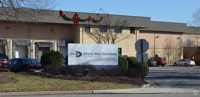
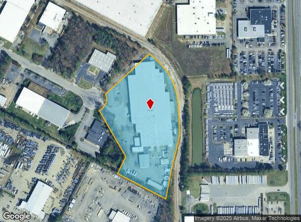
4500 Sarellen Rd
815-710-6687
Richmond Ind Intprt
Heavymanufacturing
0172030000F 0009; RICHMOND IND INTPRT SC 3 BL PT AC 7.1939 29 A1 30
X
Henrico
51087C0163D
Virginia
2025
7.19 AC
2025
Airport
201504
Richmond VA
129,768 SF
Richmond, VA
DEMOGRAPHICS near 4500 Sarellen Rd
1 Mile
3 Mile
5 Mile
2024 Total Population
1,620
41,820
114,902
2029 Population
1,603
41,877
117,059
Pop Growth 2024-2029
(1.05%)
+ 0.14%
+ 1.88%
Average Age
40
39
39
2024 Total Households
722
16,960
49,699
HH Growth 2024-2029
(0.97%)
+ 0.16%
+ 2.14%
Median Household Inc
$47,155
$51,475
$55,117
Avg Household Size
2.20
2.40
2.20
2024 Avg HH Vehicles
2.00
2.00
2.00
Median Home Value
$190,990
$179,165
$207,391
Median Year Built
1977
1980
1976
Nearby Places
Map Layers
Map Styles
 Street
 Aerial
- Restaurants
- Banks
- Shops
- Fitness
- Groceries
PUBLIC TRANSPORTATION
COMMUTER RAIL
Richmond Main Street Amtrak Station (Northeast Regional - Amtrak)
DRIVE
WALK
Distance
Richmond Main Street Amtrak Station (Northeast Regional - Amtrak)
11 min
5.4 mi
AIRPORT
Richmond International
DRIVE
WALK
Distance
Richmond International
9 min
3.9 mi
Freight Ports
Virginia Port Authority - Richmond
DRIVE
WALK
Distance
Virginia Port Authority - Richmond
19 min
10.7 mi
SALE & LEASE HISTORY
LISTING DATE
SALE/LEASE

Mar 31, 2020
For Lease
Nearby Properties
Address
Land Use
TOTAL SIZE
Lot Size
Zoning
Address
Land Use
TOTAL SIZE
Lot Size
Zoning
548,680 SF
2,298.89 AC
MIXE
Address
Land Use
TOTAL SIZE
Lot Size
Zoning
143,287 SF
56.39 AC
MIXE
Address
Land Use
TOTAL SIZE
Lot Size
Zoning
281,456 SF
84.22 AC
R-5
Address
Land Use
TOTAL SIZE
Lot Size
Zoning
26,994 SF
89.49 AC
R-5
Address
Land Use
TOTAL SIZE
Lot Size
Zoning
60,032 SF
62 AC
B-3C
Address
Land Use
TOTAL SIZE
Lot Size
Zoning
920,673 SF
99.01 AC
MIXE
Address
Land Use
TOTAL SIZE
Lot Size
Zoning
49,152 SF
31.21 AC
M-1
Address
Land Use
TOTAL SIZE
Lot Size
Zoning
15,894 SF
35.63 AC
A-1
Address
Land Use
TOTAL SIZE
Lot Size
Zoning
407,205 SF
286.12 AC
MIXE
Address
Land Use
TOTAL SIZE
Lot Size
Zoning
522,399 SF
58.07 AC
M-1
Address
Land Use
TOTAL SIZE
Lot Size
Zoning
190,000 SF
16.65 AC
R-5C
Address
Land Use
TOTAL SIZE
Lot Size
Zoning
446,500 SF
49.33 AC
M1-C
Address
Land Use
TOTAL SIZE
Lot Size
Zoning
186,390 SF
13.50 AC
R-5
Address
Land Use
TOTAL SIZE
Lot Size
Zoning
4,556 SF
8.76 AC
R-5C
Address
Land Use
TOTAL SIZE
Lot Size
Zoning
444,069 SF
23.82 AC
M-1
Address
Land Use
TOTAL SIZE
Lot Size
Zoning
173,637 SF
15.48 AC
R-5
Address
Land Use
TOTAL SIZE
Lot Size
Zoning
69,297 SF
49.66 AC
A-1
Address
Land Use
TOTAL SIZE
Lot Size
Zoning
162,289 SF
35 AC
A-1
Address
Land Use
TOTAL SIZE
Lot Size
Zoning
322,000 SF
15.94 AC
M-1
Address
Land Use
TOTAL SIZE
Lot Size
Zoning
278,967 SF
26.07 AC
M1-C
Address
Land Use
TOTAL SIZE
Lot Size
Zoning
146,560 SF
11.09 AC
R-5
Address
Land Use
TOTAL SIZE
Lot Size
Zoning
15,680 SF
39.75 AC
R-3
Address
Land Use
TOTAL SIZE
Lot Size
Zoning
8,440 SF
8.27 AC
R-6
Address
Land Use
TOTAL SIZE
Lot Size
Zoning
179,359 SF
11.85 AC
M-1
Address
Land Use
TOTAL SIZE
Lot Size
Zoning
190,138 SF
16.99 AC
MIXE
Address
Land Use
TOTAL SIZE
Lot Size
Zoning
246,760 SF
59.70 AC
M-2C
Address
Land Use
TOTAL SIZE
Lot Size
Zoning
108,738 SF
6.39 AC
R-6
Address
Land Use
TOTAL SIZE
Lot Size
Zoning
241,800 SF
M-2C
Address
Land Use
TOTAL SIZE
Lot Size
Zoning
142,379 SF
17.69 AC
M-1
Address
Land Use
TOTAL SIZE
Lot Size
Zoning
76,208 SF
24.97 AC
B-3
The World's #1 Commercial Real Estate Marketplace
Connect with us
© 2025 CoStar Group
The information above has been obtained from sources believed reliable. While we do not doubt its accuracy we have not verified it and make no guarantee, warranty or representation about it. It is your responsibility to independently confirm its accuracy and completeness. Any projections, opinions, assumptions, or estimates used are for example only and do not represent the current or future performance of the property. The value of this transaction to you depends on tax and other factors which should be evaluated by your tax, financial, and legal advisors. You and your advisors should conduct a careful, independent investigation of the property to determine to your satisfaction the suitability of the property for your needs.