Property Record
4500 Williamstown Blvd, Lakeland, FL 33810


NEARBY LISTINGS FOR SALE OR LEASE
-
-
View all Lakeland listings for sale on LoopNet.com
Property Detail
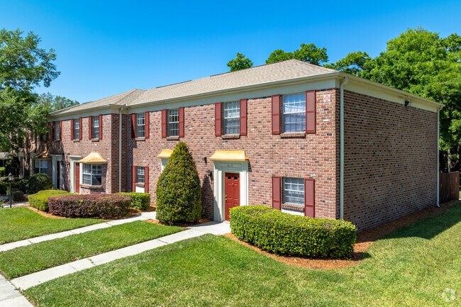
4500 Williamstown Blvd
Lakeland-Winter Haven, FL
Webster And Omohundro Subdivision
23-27-26-009500-000011
EBSTER & OMOHUNDRO SUB PB 3 PG 81 LOTS 1 THRU 10 THAT PART BEING DESC AS E 1635 FT OF S1/2 OF NW1/4 OF SEC 26 & THAT PT OF E 1635 FT OF SW1/4 OF SEC 26 LYING N & E OF MEADOW VIEW LAKE & THAT PART OF NE1/4 OF NW1/4 OF SEC 35-T27S-R23E LYING N & E OF M
Multifamilydwelling
Polk
AE
Florida
12105C0301G
1-10
2024
133.41 AC
2025
City of Lakeland
012127
Tampa/St Petersburg
1,091,160 SF
DEMOGRAPHICS near 4500 Williamstown Blvd
1 Mile
3 Mile
5 Mile
2024 Total Population
11,966
59,634
129,746
2029 Population
14,235
71,154
154,890
Pop Growth 2024-2029
+ 18.96%
+ 19.32%
+ 19.38%
Average Age
44
40
40
2024 Total Households
5,140
23,404
49,807
HH Growth 2024-2029
+ 18.97%
+ 19.20%
+ 19.54%
Median Household Inc
$63,822
$53,790
$53,181
Avg Household Size
2.20
2.40
2.50
2024 Avg HH Vehicles
2.00
2.00
2.00
Median Home Value
$253,397
$195,183
$201,073
Median Year Built
1992
1990
1988
Nearby Places
Map Layers
Map Styles
 Street
 Aerial
- Restaurants
- Banks
- Shops
- Fitness
- Groceries
PUBLIC TRANSPORTATION
COMMUTER RAIL
Lakeland (Silver Star - Amtrak)
DRIVE
WALK
Distance
Lakeland (Silver Star - Amtrak)
11 min
5.2 mi
Freight Ports
Port of Tampa Bay
DRIVE
WALK
Distance
Port of Tampa Bay
47 min
35.6 mi
Nearby Properties
Address
Land Use
TOTAL SIZE
Lot Size
Zoning
Address
Land Use
TOTAL SIZE
Lot Size
Zoning
493,501 SF
39.01 AC
MF12
Address
Land Use
TOTAL SIZE
Lot Size
Zoning
470,032 SF
23.21 AC
Address
Land Use
TOTAL SIZE
Lot Size
Zoning
363,693 SF
22.54 AC
R2
Address
Land Use
TOTAL SIZE
Lot Size
Zoning
361,669 SF
12.73 AC
Address
Land Use
TOTAL SIZE
Lot Size
Zoning
279,726 SF
19.09 AC
C3
Address
Land Use
TOTAL SIZE
Lot Size
Zoning
246,838 SF
24.57 AC
PUD
Address
Land Use
TOTAL SIZE
Lot Size
Zoning
762,259 SF
24.95 AC
PUD
Address
Land Use
TOTAL SIZE
Lot Size
Zoning
208,898 SF
17.62 AC
PUD
Address
Land Use
TOTAL SIZE
Lot Size
Zoning
79,697 SF
6.37 AC
C2
Address
Land Use
TOTAL SIZE
Lot Size
Zoning
324,191 SF
23.37 AC
PUD
Address
Land Use
TOTAL SIZE
Lot Size
Zoning
169,546 SF
14.40 AC
PUD
Address
Land Use
TOTAL SIZE
Lot Size
Zoning
226,953 SF
34.42 AC
Address
Land Use
TOTAL SIZE
Lot Size
Zoning
425,986 SF
45.72 AC
C5
Address
Land Use
TOTAL SIZE
Lot Size
Zoning
171,525 SF
40.58 AC
RC
Address
Land Use
TOTAL SIZE
Lot Size
Zoning
115,608 SF
11.44 AC
RC
Address
Land Use
TOTAL SIZE
Lot Size
Zoning
142,936 SF
26.38 AC
Address
Land Use
TOTAL SIZE
Lot Size
Zoning
156,987 SF
51.52 AC
Address
Land Use
TOTAL SIZE
Lot Size
Zoning
101,501 SF
16.54 AC
Address
Land Use
TOTAL SIZE
Lot Size
Zoning
180,802 SF
76.35 AC
Address
Land Use
TOTAL SIZE
Lot Size
Zoning
292,124 SF
29.70 AC
PUD
Address
Land Use
TOTAL SIZE
Lot Size
Zoning
87,975 SF
5.45 AC
O1
Address
Land Use
TOTAL SIZE
Lot Size
Zoning
226,634 SF
27.21 AC
C3
Address
Land Use
TOTAL SIZE
Lot Size
Zoning
183,800 SF
19.26 AC
Address
Land Use
TOTAL SIZE
Lot Size
Zoning
206,724 SF
66.04 AC
RC
Address
Land Use
TOTAL SIZE
Lot Size
Zoning
118,250 SF
23.12 AC
Address
Land Use
TOTAL SIZE
Lot Size
Zoning
152,004 SF
15.81 AC
PUD
Address
Land Use
TOTAL SIZE
Lot Size
Zoning
71,857 SF
102.49 AC
RA3
Address
Land Use
TOTAL SIZE
Lot Size
Zoning
129,281 SF
15.27 AC
PUD
Address
Land Use
TOTAL SIZE
Lot Size
Zoning
149,871 SF
7.45 AC
PUD
The World's #1 Commercial Real Estate Marketplace
Connect with us
© 2026 CoStar Group
The information above has been obtained from sources believed reliable. While we do not doubt its accuracy we have not verified it and make no guarantee, warranty or representation about it. It is your responsibility to independently confirm its accuracy and completeness. Any projections, opinions, assumptions, or estimates used are for example only and do not represent the current or future performance of the property. The value of this transaction to you depends on tax and other factors which should be evaluated by your tax, financial, and legal advisors. You and your advisors should conduct a careful, independent investigation of the property to determine to your satisfaction the suitability of the property for your needs.