No Photo
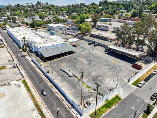
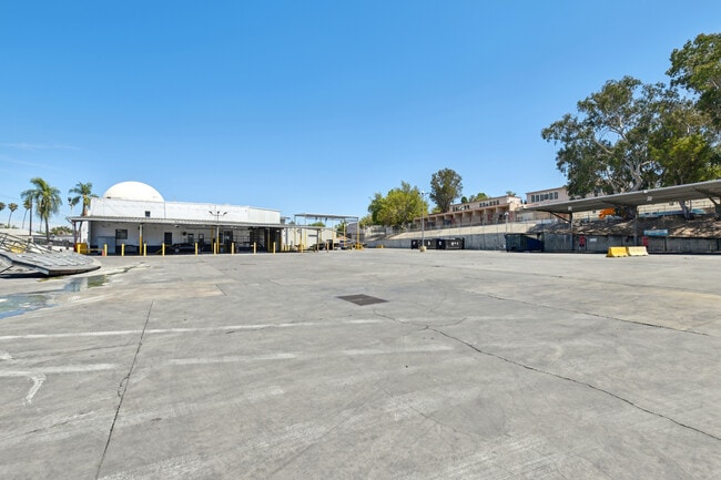
Property Record
4500 Lincoln Ave, Los Angeles, CA 90041
Current Lease Availabilities
NEARBY LISTINGS FOR SALE OR LEASE
Property Detail
4500 Lincoln Ave
Los Angeles-Long Beach-Glendale, CA
3583
5474-026-007
TRACT NO 3583 NW 35 FT (EX OF STS) OF LOT 12 AND (EX OF ST) LOT 13 AND (EX OF STS) LOTS 14 AND LOT B
Lightindustrial
Los Angeles
X
California
06037C1627F
12
2024
4.38 AC
2025
Central Los Angeles
183402
Los Angeles
157,226 SF
DEMOGRAPHICS near 4500 Lincoln Ave
1 Mile
3 Mile
5 Mile
2024 Total Population
29,337
244,465
625,749
2029 Population
28,321
235,828
605,079
Pop Growth 2024-2029
(3.46%)
(3.53%)
(3.30%)
Average Age
41
41
41
2024 Total Households
10,256
90,919
239,374
HH Growth 2024-2029
(3.77%)
(3.80%)
(3.53%)
Median Household Inc
$97,605
$82,450
$81,224
Avg Household Size
2.60
2.60
2.50
2024 Avg HH Vehicles
2.00
2.00
2.00
Median Home Value
$862,356
$887,532
$932,501
Median Year Built
1952
1957
1958
Nearby Places
Map Layers
Map Styles
 Street
 Aerial
- Restaurants
- Banks
- Shops
- Fitness
- Groceries
PUBLIC TRANSPORTATION
COMMUTER RAIL
Glendale (Antelope Valley Line - Southern California Regional Rail Authority (Metrolink), Ventura County Line - Southern California Regional Rail Authority (Metrolink))
DRIVE
WALK
Distance
Glendale (Antelope Valley Line - Southern California Regional Rail Authority (Metrolink), Ventura County Line - Southern California Regional Rail Authority (Metrolink))
6 min
3.1 mi
Union Station (91 Line - Southern California Regional Rail Authority (Metrolink), Antelope Valley Line - Southern California Regional Rail Authority (Metrolink), Orange County Line - Southern California Regional Rail Authority (Metrolink), Riverside Line - Southern California Regional Rail Authority (Metrolink), San Bernardino Line - Southern California Regional Rail Authority (Metrolink), Ventura County Line - Southern California Regional Rail Authority (Metrolink))
DRIVE
WALK
Distance
Union Station (91 Line - Southern California Regional Rail Authority (Metrolink), Antelope Valley Line - Southern California Regional Rail Authority (Metrolink), Orange County Line - Southern California Regional Rail Authority (Metrolink), Riverside Line - Southern California Regional Rail Authority (Metrolink), San Bernardino Line - Southern California Regional Rail Authority (Metrolink), Ventura County Line - Southern California Regional Rail Authority (Metrolink))
14 min
6.3 mi
AIRPORT
Bob Hope
DRIVE
WALK
Distance
Bob Hope
21 min
13.9 mi
Los Angeles International
DRIVE
WALK
Distance
Los Angeles International
35 min
21.4 mi
Long Beach (Daugherty Field)
DRIVE
WALK
Distance
Long Beach (Daugherty Field)
40 min
28.0 mi
Freight Ports
Port of Long Beach
DRIVE
WALK
Distance
Port of Long Beach
42 min
30.8 mi
Nearby Properties
Address
Land Use
TOTAL SIZE
Lot Size
Zoning
Address
Land Use
TOTAL SIZE
Lot Size
Zoning
272,288 SF
24.26 AC
GLC3-C2-R4
Address
Land Use
TOTAL SIZE
Lot Size
Zoning
590,292 SF
8.21 AC
GLC3*
Address
Land Use
TOTAL SIZE
Lot Size
Zoning
477,885 SF
2.52 AC
GLC3*
Address
Land Use
TOTAL SIZE
Lot Size
Zoning
251,317 SF
114.56 AC
LAR1
Address
Land Use
TOTAL SIZE
Lot Size
Zoning
985,517 SF
4.08 AC
GLC3
Address
Land Use
TOTAL SIZE
Lot Size
Zoning
349,519 SF
2.16 AC
GLM1*
Address
Land Use
TOTAL SIZE
Lot Size
Zoning
245,031 SF
2.21 AC
GLM2
Address
Land Use
TOTAL SIZE
Lot Size
Zoning
457,694 SF
1.42 AC
GLC3*
Address
Land Use
TOTAL SIZE
Lot Size
Zoning
122,988 SF
3.32 AC
GLC3*
Address
Land Use
TOTAL SIZE
Lot Size
Zoning
220,624 SF
1.50 AC
GLC3-C2*
Address
Land Use
TOTAL SIZE
Lot Size
Zoning
189,663 SF
1.36 AC
GLC2*
Address
Land Use
TOTAL SIZE
Lot Size
Zoning
119,455 SF
5.04 AC
LACM
Address
Land Use
TOTAL SIZE
Lot Size
Zoning
53,760 SF
4.60 AC
LAM1
Address
Land Use
TOTAL SIZE
Lot Size
Zoning
178,932 SF
0.88 AC
GLC3*
Address
Land Use
TOTAL SIZE
Lot Size
Zoning
1,119,154 SF
LAC4
Address
Land Use
TOTAL SIZE
Lot Size
Zoning
58,941 SF
1.35 AC
GLC3*
Address
Land Use
TOTAL SIZE
Lot Size
Zoning
145,740 SF
0.76 AC
GLC3YY
Address
Land Use
TOTAL SIZE
Lot Size
Zoning
222,940 SF
2.48 AC
LAC2
Address
Land Use
TOTAL SIZE
Lot Size
Zoning
329,802 SF
1.05 AC
GLC3*
Address
Land Use
TOTAL SIZE
Lot Size
Zoning
81,932 SF
0.70 AC
GLC3*
Address
Land Use
TOTAL SIZE
Lot Size
Zoning
314,760 SF
3.77 AC
GLC3
Address
Land Use
TOTAL SIZE
Lot Size
Zoning
109,912 SF
0.42 AC
GLC3*
Address
Land Use
TOTAL SIZE
Lot Size
Zoning
174,561 SF
1.07 AC
GLC3*
Address
Land Use
TOTAL SIZE
Lot Size
Zoning
78,918 SF
0.98 AC
GLC3
Address
Land Use
TOTAL SIZE
Lot Size
Zoning
97,161 SF
0.53 AC
GLC3*
Address
Land Use
TOTAL SIZE
Lot Size
Zoning
102,722 SF
0.42 AC
GLC3*
Address
Land Use
TOTAL SIZE
Lot Size
Zoning
100,184 SF
5.68 AC
LAM2
Address
Land Use
TOTAL SIZE
Lot Size
Zoning
118,320 SF
8.01 AC
LAM2
Address
Land Use
TOTAL SIZE
Lot Size
Zoning
100,278 SF
0.70 AC
GLC3*
Address
Land Use
TOTAL SIZE
Lot Size
Zoning
34,182 SF
1.12 AC
GLC3*
The World's #1 Commercial Real Estate Marketplace
Connect with us
© 2025 CoStar Group
The information above has been obtained from sources believed reliable. While we do not doubt its accuracy we have not verified it and make no guarantee, warranty or representation about it. It is your responsibility to independently confirm its accuracy and completeness. Any projections, opinions, assumptions, or estimates used are for example only and do not represent the current or future performance of the property. The value of this transaction to you depends on tax and other factors which should be evaluated by your tax, financial, and legal advisors. You and your advisors should conduct a careful, independent investigation of the property to determine to your satisfaction the suitability of the property for your needs.