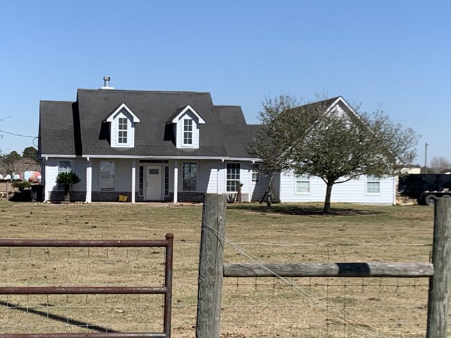
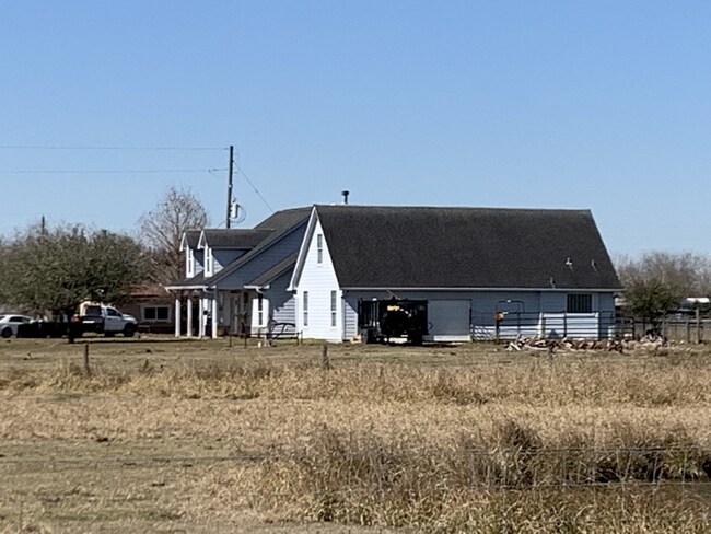
Property Record
4501 Baker Rd, Needville, TX 77461

Property Detail
4501 Baker Rd
0669-00-000-0980-906
0669 STILES AND WARD, ACRES 17.95
Commercialnec
FORT BEND
YTQ
Texas
B and X Area of moderate flood hazard, usually the area between the limits of the 100-year and 500-year floods.
11
2024
17.95 AC
2025
Southwest Outlier
675701
Houston
2,870 SF
Houston-Pasadena-The Woodlands, TX
NEARBY LISTINGS FOR SALE OR LEASE
DEMOGRAPHICS near 4501 Baker Rd
1 mile
3 mile
5 mile
2024 Total Population
547
3,033
13,334
2029 Population
651
3,614
16,063
Pop Growth 2024-2029
+ 19.01%
+ 19.16%
+ 20.47%
Average Age
40
40
38
2024 Total Households
179
1,002
4,343
HH Growth 2024-2029
+ 20.11%
+ 19.76%
+ 20.98%
Median Household Inc
$32,699
$48,749
$67,707
Avg Household Size
3.10
3.00
3.00
2024 Avg HH Vehicles
2.00
2.00
2.00
Median Home Value
$246,794
$254,017
$242,491
Median Year Built
1991
1989
1990
Nearby Places
Map Layers
Map Styles
 Street
 Aerial
Transit
 Traffic
 Biking
Places
Listings with unknown addresses are not visible on the map
- Restaurants
- Banks
- Shops
- Fitness
- Groceries
SALE & LEASE HISTORY
LISTING DATE
SALE/LEASE

Feb 16, 2022
For Sale
Nearby Properties
Address
Land Use
TOTAL SIZE
Lot Size
Zoning
Address
Land Use
TOTAL SIZE
Lot Size
Zoning
208.52 AC
OST
Address
Land Use
TOTAL SIZE
Lot Size
Zoning
30.46 AC
S
Address
Land Use
TOTAL SIZE
Lot Size
Zoning
11,030 SF
12.30 AC
Address
Land Use
TOTAL SIZE
Lot Size
Zoning
5,862 SF
26.57 AC
Address
Land Use
TOTAL SIZE
Lot Size
Zoning
9.17 AC
Address
Land Use
TOTAL SIZE
Lot Size
Zoning
864 SF
49.50 AC
SO
Address
Land Use
TOTAL SIZE
Lot Size
Zoning
6,945 SF
18.39 AC
QS
Address
Land Use
TOTAL SIZE
Lot Size
Zoning
45 AC
QY
Address
Land Use
TOTAL SIZE
Lot Size
Zoning
140 AC
TY
Address
Land Use
TOTAL SIZE
Lot Size
Zoning
5,000 SF
4.70 AC
SH
Address
Land Use
TOTAL SIZE
Lot Size
Zoning
4,253 SF
5.40 AC
OS
Address
Land Use
TOTAL SIZE
Lot Size
Zoning
2,870 SF
3.64 AC
Address
Land Use
TOTAL SIZE
Lot Size
Zoning
2,516 SF
10.61 AC
Address
Land Use
TOTAL SIZE
Lot Size
Zoning
Address
Land Use
TOTAL SIZE
Lot Size
Zoning
9.74 AC
OYS
Address
Land Use
TOTAL SIZE
Lot Size
Zoning
736 SF
15 AC
Address
Land Use
TOTAL SIZE
Lot Size
Zoning
56.56 AC
KOST
Address
Land Use
TOTAL SIZE
Lot Size
Zoning
8.35 AC
Address
Land Use
TOTAL SIZE
Lot Size
Zoning
12.50 AC
Address
Land Use
TOTAL SIZE
Lot Size
Zoning
Address
Land Use
TOTAL SIZE
Lot Size
Zoning
28.65 AC
OS
Address
Land Use
TOTAL SIZE
Lot Size
Zoning
5,800 SF
13.43 AC
Address
Land Use
TOTAL SIZE
Lot Size
Zoning
1,172 SF
3.95 AC
Address
Land Use
TOTAL SIZE
Lot Size
Zoning
Address
Land Use
TOTAL SIZE
Lot Size
Zoning
3,573 SF
2.53 AC
Address
Land Use
TOTAL SIZE
Lot Size
Zoning
1,020 SF
5.12 AC
Address
Land Use
TOTAL SIZE
Lot Size
Zoning
1,488 SF
0.40 AC
Address
Land Use
TOTAL SIZE
Lot Size
Zoning
35.41 AC
ZOT
Address
Land Use
TOTAL SIZE
Lot Size
Zoning
5,275 SF
3 AC
R
The World's #1 Commercial Real Estate Marketplace
Connect with us
© 2026 CoStar Group
The information above has been obtained from sources believed reliable. While we do not doubt its accuracy we have not verified it and make no guarantee, warranty or representation about it. It is your responsibility to independently confirm its accuracy and completeness. Any projections, opinions, assumptions, or estimates used are for example only and do not represent the current or future performance of the property. The value of this transaction to you depends on tax and other factors which should be evaluated by your tax, financial, and legal advisors. You and your advisors should conduct a careful, independent investigation of the property to determine to your satisfaction the suitability of the property for your needs.