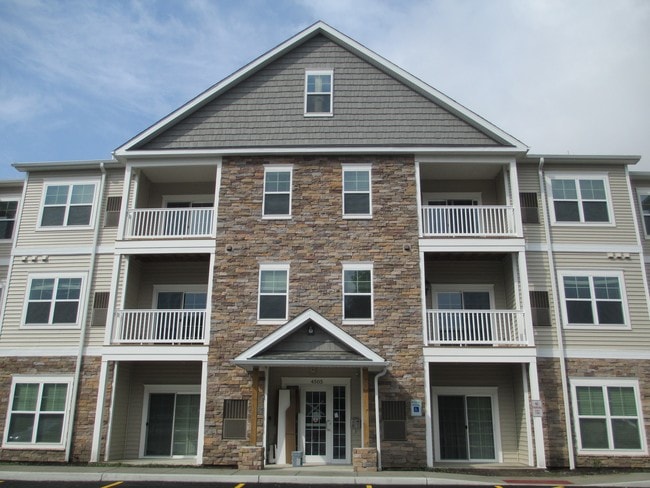
Property Record
4501 Chestnut Ridge Rd, Buffalo, NY 14228

NEARBY LISTINGS FOR SALE OR LEASE
Property Detail
4501 Chestnut Ridge Rd
Buffalo-Cheektowaga-Niagara Falls, NY
The Holland Land Companys Survey
142289-054-020-0001-028-110
79/80/86 12 7
Apartment
Erie
X
New York
36029C0068H
28.110
2025
9.41 AC
2024
East Amherst/Williamsville
009115
Buffalo/Niagara Falls
32,361 SF
DEMOGRAPHICS near 4501 Chestnut Ridge Rd
1 Mile
3 Mile
5 Mile
2024 Total Population
17,263
104,527
292,165
2029 Population
17,242
104,385
289,180
Pop Growth 2024-2029
(0.12%)
(0.14%)
(1.02%)
Average Age
32
40
41
2024 Total Households
4,859
43,243
124,508
HH Growth 2024-2029
+ 0.14%
(0.10%)
(1.10%)
Median Household Inc
$46,620
$66,233
$67,177
Avg Household Size
2.10
2.20
2.20
2024 Avg HH Vehicles
1.00
2.00
2.00
Median Home Value
$182,877
$184,230
$191,260
Median Year Built
1978
1960
1955
Nearby Places
Map Layers
Map Styles
 Street
 Aerial
- Restaurants
- Banks
- Shops
- Fitness
- Groceries
PUBLIC TRANSPORTATION
AIRPORT
Buffalo Niagara International
DRIVE
WALK
Distance
Buffalo Niagara International
17 min
8.5 mi
Niagara Falls International
DRIVE
WALK
Distance
Niagara Falls International
21 min
11.1 mi
Freight Ports
Port of Toledo
DRIVE
WALK
Distance
Port of Toledo
372 min
313.1 mi
Nearby Properties
Address
Land Use
TOTAL SIZE
Lot Size
Zoning
Address
Land Use
TOTAL SIZE
Lot Size
Zoning
2,592,064 SF
1,057.90 AC
Address
Land Use
TOTAL SIZE
Lot Size
Zoning
109,328 SF
12.77 AC
GB
Address
Land Use
TOTAL SIZE
Lot Size
Zoning
409,925 SF
36.41 AC
CTR-5
Address
Land Use
TOTAL SIZE
Lot Size
Zoning
132,940 SF
41.50 AC
CF
Address
Land Use
TOTAL SIZE
Lot Size
Zoning
283,706 SF
68.90 AC
Address
Land Use
TOTAL SIZE
Lot Size
Zoning
177,000 SF
14.91 AC
CF
Address
Land Use
TOTAL SIZE
Lot Size
Zoning
41,104 SF
27.52 AC
Address
Land Use
TOTAL SIZE
Lot Size
Zoning
2,592 SF
22.75 AC
NCD
Address
Land Use
TOTAL SIZE
Lot Size
Zoning
16,065 SF
19.75 AC
Address
Land Use
TOTAL SIZE
Lot Size
Zoning
8,565 SF
22.65 AC
Address
Land Use
TOTAL SIZE
Lot Size
Zoning
12,262 SF
29 AC
MFR-5
Address
Land Use
TOTAL SIZE
Lot Size
Zoning
70,261 SF
14.63 AC
CTR-5
Address
Land Use
TOTAL SIZE
Lot Size
Zoning
100,737 SF
21.10 AC
CTR-5
Address
Land Use
TOTAL SIZE
Lot Size
Zoning
213,943 SF
5.50 AC
Address
Land Use
TOTAL SIZE
Lot Size
Zoning
117,980 SF
14.40 AC
CTR-5
Address
Land Use
TOTAL SIZE
Lot Size
Zoning
181,897 SF
15.30 AC
CTR-2.5
Address
Land Use
TOTAL SIZE
Lot Size
Zoning
8,842 SF
29.30 AC
Address
Land Use
TOTAL SIZE
Lot Size
Zoning
17,778 SF
14 AC
GB
Address
Land Use
TOTAL SIZE
Lot Size
Zoning
197,430 SF
8.20 AC
Address
Land Use
TOTAL SIZE
Lot Size
Zoning
197,430 SF
7.35 AC
Address
Land Use
TOTAL SIZE
Lot Size
Zoning
3,456 SF
6.90 AC
MFR-5
Address
Land Use
TOTAL SIZE
Lot Size
Zoning
83,256 SF
8.01 AC
NCD
Address
Land Use
TOTAL SIZE
Lot Size
Zoning
191,420 SF
59.30 AC
Address
Land Use
TOTAL SIZE
Lot Size
Zoning
132,000 SF
9.40 AC
Address
Land Use
TOTAL SIZE
Lot Size
Zoning
6,384 SF
13.40 AC
Address
Land Use
TOTAL SIZE
Lot Size
Zoning
11,248 SF
21.70 AC
MFR-5
Address
Land Use
TOTAL SIZE
Lot Size
Zoning
28,530 SF
30.20 AC
NCD
Address
Land Use
TOTAL SIZE
Lot Size
Zoning
122,669 SF
7.94 AC
CTR-2.5
Address
Land Use
TOTAL SIZE
Lot Size
Zoning
109,461 SF
7.90 AC
CTR-5
Address
Land Use
TOTAL SIZE
Lot Size
Zoning
2,135 SF
11.96 AC
The World's #1 Commercial Real Estate Marketplace
Connect with us
© 2026 CoStar Group
The information above has been obtained from sources believed reliable. While we do not doubt its accuracy we have not verified it and make no guarantee, warranty or representation about it. It is your responsibility to independently confirm its accuracy and completeness. Any projections, opinions, assumptions, or estimates used are for example only and do not represent the current or future performance of the property. The value of this transaction to you depends on tax and other factors which should be evaluated by your tax, financial, and legal advisors. You and your advisors should conduct a careful, independent investigation of the property to determine to your satisfaction the suitability of the property for your needs.