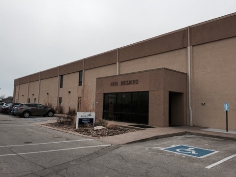
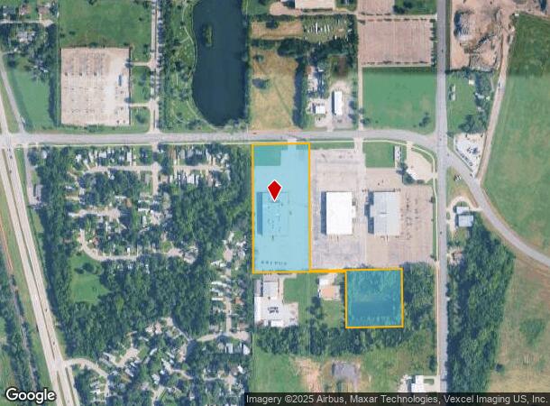
Property Record
4501 E 47Th St S, Wichita, KS 67210

Current Lease Availabilities
NEARBY LISTINGS FOR SALE OR LEASE
-
-
View all Wichita listings for lease on LoopNet.com
Property Detail
4501 E 47Th St S
Wichita, KS
Chelsea Industrial Park Add
216-23-0-11-01-004.00
LOT 1 EXC BEG SW COR E 639.99 FT N 382.55 FT W 639.96 FT TO W LI S 389.17 FT TO BEG & EXC BEG NE COR S876.38 FT W 402.06 FT N 875.77 FT TO N LI E 402.07 FT TO BEG BLOCK A CHELSEA INDUSTRIAL PARK ADD
Officebuilding
Sedgwick
X
Kansas
20173C0506G
1
2024
11.49 AC
2025
Southeast
005800
Wichita
50,605 SF
DEMOGRAPHICS near 4501 E 47Th St S
1 Mile
3 Mile
5 Mile
2024 Total Population
3,524
32,657
134,202
2029 Population
3,622
33,519
137,147
Pop Growth 2024-2029
+ 2.78%
+ 2.64%
+ 2.19%
Average Age
36
36
37
2024 Total Households
1,325
12,230
53,049
HH Growth 2024-2029
+ 2.72%
+ 2.35%
+ 2.12%
Median Household Inc
$38,615
$51,134
$50,011
Avg Household Size
2.50
2.60
2.40
2024 Avg HH Vehicles
2.00
2.00
2.00
Median Home Value
$56,583
$130,832
$123,997
Median Year Built
1965
1987
1972
Nearby Places
- Restaurants
- Banks
- Shops
- Fitness
- Groceries
PUBLIC TRANSPORTATION
AIRPORT
Wichita Dwight D Eisenhower Ntl
DRIVE
WALK
Distance
Wichita Dwight D Eisenhower Ntl
21 min
13.3 mi
Freight Ports
Tulsa Port Of Catoosa
DRIVE
WALK
Distance
Tulsa Port Of Catoosa
201 min
188.8 mi
Nearby Properties
Address
Land Use
TOTAL SIZE
Lot Size
Zoning
Address
Land Use
TOTAL SIZE
Lot Size
Zoning
418.47 AC
AFB
Address
Land Use
TOTAL SIZE
Lot Size
Zoning
172,691 SF
17.25 AC
RR
Address
Land Use
TOTAL SIZE
Lot Size
Zoning
152,978 SF
7.86 AC
LI
Address
Land Use
TOTAL SIZE
Lot Size
Zoning
3,063,858 SF
57.81 AC
LI
Address
Land Use
TOTAL SIZE
Lot Size
Zoning
81,569 SF
12.09 AC
Address
Land Use
TOTAL SIZE
Lot Size
Zoning
233,436 SF
20.38 AC
LI
Address
Land Use
TOTAL SIZE
Lot Size
Zoning
62,580 SF
7.83 AC
SF20
Address
Land Use
TOTAL SIZE
Lot Size
Zoning
67,145 SF
11.49 AC
LI
Address
Land Use
TOTAL SIZE
Lot Size
Zoning
42,611 SF
7.01 AC
B3
Address
Land Use
TOTAL SIZE
Lot Size
Zoning
106,159 SF
16.16 AC
SF-5
Address
Land Use
TOTAL SIZE
Lot Size
Zoning
49,336 SF
19.20 AC
I1
Address
Land Use
TOTAL SIZE
Lot Size
Zoning
119,245 SF
10.77 AC
MF29
Address
Land Use
TOTAL SIZE
Lot Size
Zoning
71,651 SF
5.82 AC
SF-5
Address
Land Use
TOTAL SIZE
Lot Size
Zoning
67,322 SF
9.05 AC
R1
Address
Land Use
TOTAL SIZE
Lot Size
Zoning
35,528 SF
7.15 AC
LC
Address
Land Use
TOTAL SIZE
Lot Size
Zoning
59,964 SF
16.85 AC
LI,LC
Address
Land Use
TOTAL SIZE
Lot Size
Zoning
53,626 SF
8.03 AC
SF-5
Address
Land Use
TOTAL SIZE
Lot Size
Zoning
1,014,655 SF
24.68 AC
LI
Address
Land Use
TOTAL SIZE
Lot Size
Zoning
40,926 SF
5.21 AC
LI
Address
Land Use
TOTAL SIZE
Lot Size
Zoning
31,440 SF
21.30 AC
SF-5
Address
Land Use
TOTAL SIZE
Lot Size
Zoning
28,912 SF
12.31 AC
SF-5,LC
Address
Land Use
TOTAL SIZE
Lot Size
Zoning
15,852 SF
73.15 AC
SF-5
Address
Land Use
TOTAL SIZE
Lot Size
Zoning
88,453 SF
10.91 AC
Address
Land Use
TOTAL SIZE
Lot Size
Zoning
52,285 SF
21.20 AC
R3
Address
Land Use
TOTAL SIZE
Lot Size
Zoning
47,869 SF
29.55 AC
SF-5
Address
Land Use
TOTAL SIZE
Lot Size
Zoning
1,184,105 SF
261.18 AC
LI
Address
Land Use
TOTAL SIZE
Lot Size
Zoning
46,419 SF
11.46 AC
SF-5
Address
Land Use
TOTAL SIZE
Lot Size
Zoning
27,362 SF
14.50 AC
SF-5
The World's #1 Commercial Real Estate Marketplace
Connect with us
© 2025 CoStar Group
The information above has been obtained from sources believed reliable. While we do not doubt its accuracy we have not verified it and make no guarantee, warranty or representation about it. It is your responsibility to independently confirm its accuracy and completeness. Any projections, opinions, assumptions, or estimates used are for example only and do not represent the current or future performance of the property. The value of this transaction to you depends on tax and other factors which should be evaluated by your tax, financial, and legal advisors. You and your advisors should conduct a careful, independent investigation of the property to determine to your satisfaction the suitability of the property for your needs.