Property Record
4501 E Palmetto St, Florence, SC 29506

Save to a Folder
{{folder.Name}}
{{folder.ListingIds.length}} Properties
{{folder.ListingIds.length}} Property
Create a New Folder
This Property Is For Sale
Current Lease Availabilities
Property Detail
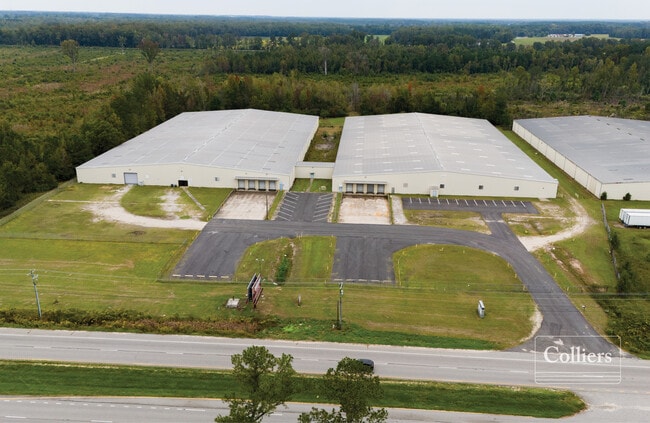
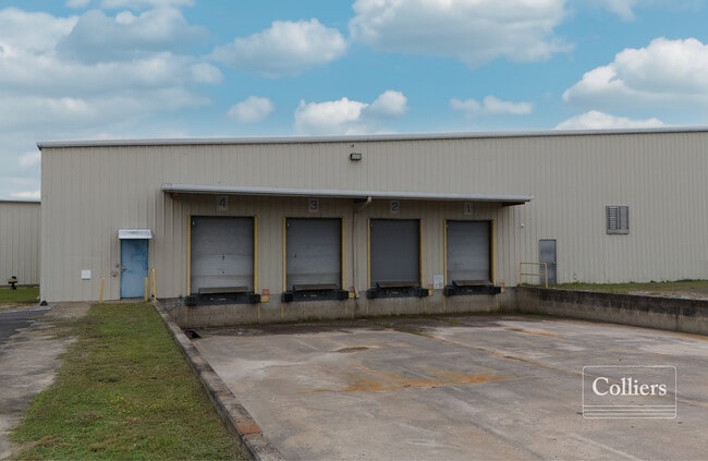
4501 E Palmetto St
00241-01-023
OFF E PALMETTO TRKS A-D
Warehouse
FLORENCE
B and X Area of moderate flood hazard, usually the area between the limits of the 100-year and 500-year floods.
South Carolina
2025
11.14 AC
2025
Florence/Dillon
000400
Other Market Areas
201,000 SF
Florence, SC
NEARBY LISTINGS FOR SALE OR LEASE
DEMOGRAPHICS near 4501 E Palmetto St
1 mile
3 mile
5 mile
2025 Total Population
662
6,294
16,858
2030 Population
678
6,435
17,250
Pop Growth 2025-2030
+ 2.42%
+ 2.24%
+ 2.33%
Average Age
37
38
38
2025 Total Households
280
2,384
6,185
HH Growth 2025-2030
+ 2.50%
+ 2.43%
+ 2.55%
Median Household Inc
$38,055
$47,165
$47,105
Avg Household Size
2.30
2.40
2.40
2025 Avg HH Vehicles
2.00
2.00
2.00
Median Home Value
$134,210
$152,375
$146,701
Median Year Built
1989
1987
1987
Nearby Places
Map Layers
Map Styles
 Street
 Aerial
Layers
 Traffic
 Biking
Places
Listings with unknown addresses are not visible on the map
- Restaurants
- Banks
- Shops
- Fitness
- Groceries
PUBLIC TRANSPORTATION
COMMUTER RAIL
Florence Amtrak Station (Palmetto - Amtrak, Silver Meteor - Amtrak)
Drive
Walk
Distance
Florence Amtrak Station (Palmetto - Amtrak, Silver Meteor - Amtrak)
9 min
5.4 mi
Freight Ports
North Charleston Terminal
Drive
Walk
Distance
North Charleston Terminal
146 min
107.5 mi
Nearby Properties
Address
Land Use
TOTAL SIZE
Lot Size
Zoning
Address
Land Use
TOTAL SIZE
Lot Size
Zoning
Address
Land Use
TOTAL SIZE
Lot Size
Zoning
15,408 SF
9.08 AC
Address
Land Use
TOTAL SIZE
Lot Size
Zoning
58.01 AC
Address
Land Use
TOTAL SIZE
Lot Size
Zoning
10,610 SF
3.05 AC
Address
Land Use
TOTAL SIZE
Lot Size
Zoning
42,930 SF
5.90 AC
Address
Land Use
TOTAL SIZE
Lot Size
Zoning
69,600 SF
Address
Land Use
TOTAL SIZE
Lot Size
Zoning
Address
Land Use
TOTAL SIZE
Lot Size
Zoning
88,000 SF
24.53 AC
Address
Land Use
TOTAL SIZE
Lot Size
Zoning
2,508 SF
1.39 AC
Address
Land Use
TOTAL SIZE
Lot Size
Zoning
92.50 AC
Address
Land Use
TOTAL SIZE
Lot Size
Zoning
69,092 SF
8.57 AC
Address
Land Use
TOTAL SIZE
Lot Size
Zoning
200,000 SF
8.10 AC
Address
Land Use
TOTAL SIZE
Lot Size
Zoning
7,616 SF
33.92 AC
Address
Land Use
TOTAL SIZE
Lot Size
Zoning
19,800 SF
B6
Address
Land Use
TOTAL SIZE
Lot Size
Zoning
364.80 AC
Address
Land Use
TOTAL SIZE
Lot Size
Zoning
19,366 SF
4.59 AC
Address
Land Use
TOTAL SIZE
Lot Size
Zoning
8,988 SF
1.52 AC
Address
Land Use
TOTAL SIZE
Lot Size
Zoning
12,416 SF
9.41 AC
Address
Land Use
TOTAL SIZE
Lot Size
Zoning
2,988 SF
2.33 AC
Address
Land Use
TOTAL SIZE
Lot Size
Zoning
331.51 AC
Address
Land Use
TOTAL SIZE
Lot Size
Zoning
8,000 SF
1.40 AC
Address
Land Use
TOTAL SIZE
Lot Size
Zoning
18.34 AC
Address
Land Use
TOTAL SIZE
Lot Size
Zoning
8,370 SF
4 AC
Address
Land Use
TOTAL SIZE
Lot Size
Zoning
4,606 SF
1.88 AC
Address
Land Use
TOTAL SIZE
Lot Size
Zoning
Address
Land Use
TOTAL SIZE
Lot Size
Zoning
3,662 SF
1.52 AC
Address
Land Use
TOTAL SIZE
Lot Size
Zoning
8,500 SF
1.05 AC
Address
Land Use
TOTAL SIZE
Lot Size
Zoning
3,448 SF
1.04 AC
Address
Land Use
TOTAL SIZE
Lot Size
Zoning
The World's #1 Commercial Real Estate Marketplace
Connect with us
© 2026 CoStar Group
The information above has been obtained from sources believed reliable. While we do not doubt its accuracy we have not verified it and make no guarantee, warranty or representation about it. It is your responsibility to independently confirm its accuracy and completeness. Any projections, opinions, assumptions, or estimates used are for example only and do not represent the current or future performance of the property. The value of this transaction to you depends on tax and other factors which should be evaluated by your tax, financial, and legal advisors. You and your advisors should conduct a careful, independent investigation of the property to determine to your satisfaction the suitability of the property for your needs.