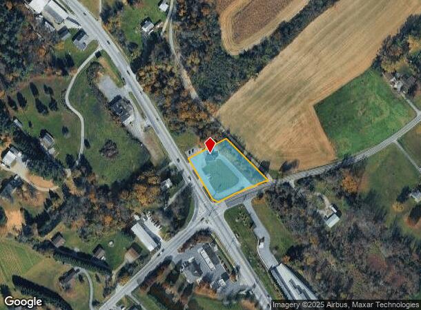
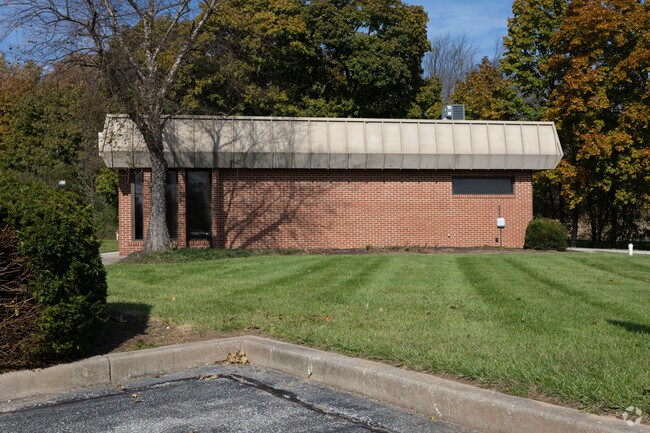
Property Record
4501 Hanover Pike, Manchester, MD 21102

NEARBY LISTINGS FOR SALE OR LEASE
Property Detail
4501 Hanover Pike
06-016413
LT - 1.0492 ACS 4501 HANOVER PK N OR MEL MERGER RECRD 10/29/08
Officebuilding
Carroll
X
Maryland
24013C0100D
1.05 AC
2024
Carroll County
2025
Baltimore
506200
Baltimore-Columbia-Towson, MD
645 SF
DEMOGRAPHICS near 4501 Hanover Pike
1 Mile
3 Mile
5 Mile
2024 Total Population
726
7,808
20,095
2029 Population
738
7,932
20,432
Pop Growth 2024-2029
+ 1.65%
+ 1.59%
+ 1.68%
Average Age
41
42
42
2024 Total Households
258
2,781
7,171
HH Growth 2024-2029
+ 1.55%
+ 1.58%
+ 1.69%
Median Household Inc
$97,069
$96,466
$94,226
Avg Household Size
2.80
2.80
2.80
2024 Avg HH Vehicles
3.00
3.00
3.00
Median Home Value
$412,820
$363,953
$336,283
Median Year Built
1983
1983
1983
Nearby Places
Map Layers
Map Styles
 Street
 Aerial
- Restaurants
- Banks
- Shops
- Fitness
- Groceries
SALE & LEASE HISTORY
LISTING DATE
SALE/LEASE

Dec 07, 2020
For Lease
Aug 12, 2020
For Lease
Nearby Properties
Address
Land Use
TOTAL SIZE
Lot Size
Zoning
Address
Land Use
TOTAL SIZE
Lot Size
Zoning
72,000 SF
20.03 AC
CONSE
Address
Land Use
TOTAL SIZE
Lot Size
Zoning
56,752 SF
5 AC
PUBLI
Address
Land Use
TOTAL SIZE
Lot Size
Zoning
2,078 SF
2.09 AC
BL
Address
Land Use
TOTAL SIZE
Lot Size
Zoning
2,440 SF
42.38 AC
PUBLI
Address
Land Use
TOTAL SIZE
Lot Size
Zoning
1,350 SF
41.15 AC
AGRIC
Address
Land Use
TOTAL SIZE
Lot Size
Zoning
13,188 SF
3.42 AC
AGRIC
Address
Land Use
TOTAL SIZE
Lot Size
Zoning
6,209 SF
0.42 AC
BL
Address
Land Use
TOTAL SIZE
Lot Size
Zoning
17,210 SF
0.50 AC
BL
Address
Land Use
TOTAL SIZE
Lot Size
Zoning
9,728 SF
2 AC
BL
Address
Land Use
TOTAL SIZE
Lot Size
Zoning
2,881 SF
3.30 AC
C-2
Address
Land Use
TOTAL SIZE
Lot Size
Zoning
2,040 SF
2.60 AC
BL
Address
Land Use
TOTAL SIZE
Lot Size
Zoning
740 SF
10.48 AC
C-3
Address
Land Use
TOTAL SIZE
Lot Size
Zoning
22,600 SF
9.35 AC
C-2
Address
Land Use
TOTAL SIZE
Lot Size
Zoning
4,884 SF
4.76 AC
I-1
Address
Land Use
TOTAL SIZE
Lot Size
Zoning
5,400 SF
1 AC
C-2
Address
Land Use
TOTAL SIZE
Lot Size
Zoning
8,374 SF
6 AC
PUBLI
Address
Land Use
TOTAL SIZE
Lot Size
Zoning
10,656 SF
0.59 AC
R-100
Address
Land Use
TOTAL SIZE
Lot Size
Zoning
9,744 SF
0.58 AC
R-750
Address
Land Use
TOTAL SIZE
Lot Size
Zoning
8,330 SF
2.60 AC
I-1
Address
Land Use
TOTAL SIZE
Lot Size
Zoning
1,348 SF
0.25 AC
BL
Address
Land Use
TOTAL SIZE
Lot Size
Zoning
8,352 SF
0.51 AC
R-750
Address
Land Use
TOTAL SIZE
Lot Size
Zoning
2,160 SF
12.42 AC
PUBLI
Address
Land Use
TOTAL SIZE
Lot Size
Zoning
13,984 SF
1.65 AC
BL
Address
Land Use
TOTAL SIZE
Lot Size
Zoning
14,864 SF
0.17 AC
BL
Address
Land Use
TOTAL SIZE
Lot Size
Zoning
2,447 SF
0.23 AC
BL
Address
Land Use
TOTAL SIZE
Lot Size
Zoning
3,544 SF
6 AC
AGRIC
Address
Land Use
TOTAL SIZE
Lot Size
Zoning
4,034 SF
0.28 AC
BL
Address
Land Use
TOTAL SIZE
Lot Size
Zoning
6.99 AC
PUBLI
Address
Land Use
TOTAL SIZE
Lot Size
Zoning
17,109 SF
2.86 AC
BG
Address
Land Use
TOTAL SIZE
Lot Size
Zoning
2,800 SF
8.73 AC
C-2
The World's #1 Commercial Real Estate Marketplace
Connect with us
© 2025 CoStar Group
The information above has been obtained from sources believed reliable. While we do not doubt its accuracy we have not verified it and make no guarantee, warranty or representation about it. It is your responsibility to independently confirm its accuracy and completeness. Any projections, opinions, assumptions, or estimates used are for example only and do not represent the current or future performance of the property. The value of this transaction to you depends on tax and other factors which should be evaluated by your tax, financial, and legal advisors. You and your advisors should conduct a careful, independent investigation of the property to determine to your satisfaction the suitability of the property for your needs.