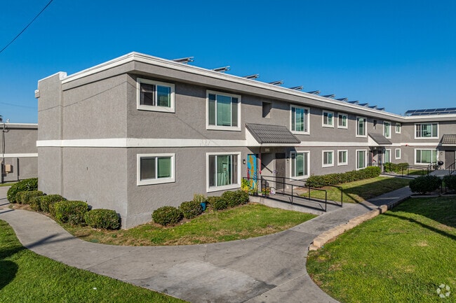
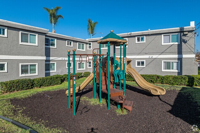
Property Record
4501 Logan Ave, San Diego, CA 92113

Save to a Folder
{{folder.Name}}
{{folder.ListingIds.length}} Properties
{{folder.ListingIds.length}} Property
Create a New Folder
Property Detail
4501 Logan Ave
San Diego-Chula Vista-Carlsbad, CA
LOT 61 /EXC ST/ & /EXC ST OP/ N 1/2 OF NW 1/4 OF TR 283
551-190-01
San Diego
Multifamilydwelling
California
RM-2-5
61
B and X Area of moderate flood hazard, usually the area between the limits of the 100-year and 500-year floods.
4.12 AC
2025
Mountain View
2025
San Diego
003303
NEARBY LISTINGS FOR SALE OR LEASE
DEMOGRAPHICS near 4501 Logan Ave
1 mile
3 mile
5 mile
2025 Total Population
37,587
225,269
602,306
2030 Population
37,581
225,329
605,176
Pop Growth 2025-2030
(0.02%)
+ 0.03%
+ 0.48%
Average Age
35
37
39
2025 Total Households
10,064
66,142
218,448
HH Growth 2025-2030
(0.14%)
(0.09%)
+ 0.61%
Median Household Inc
$64,926
$75,073
$84,761
Avg Household Size
3.60
3.20
2.60
2025 Avg HH Vehicles
2.00
2.00
2.00
Median Home Value
$634,031
$700,860
$754,291
Median Year Built
1970
1966
1972
Nearby Places
Map Layers
Map Styles
 Street
 Aerial
Layers
 Traffic
 Biking
Places
Listings with unknown addresses are not visible on the map
- Restaurants
- Banks
- Shops
- Fitness
- Groceries
PUBLIC TRANSPORTATION
COMMUTER RAIL
San Diego (Santa Fe Depot) (Coaster - San Diego North County Transit District (Coaster/Sprinter/Breeze))
Drive
Walk
Distance
San Diego (Santa Fe Depot) (Coaster - San Diego North County Transit District (Coaster/Sprinter/Breeze))
10 min
5.3 mi
Old Town Transit Center (Coaster - San Diego North County Transit District (Coaster/Sprinter/Breeze))
Drive
Walk
Distance
Old Town Transit Center (Coaster - San Diego North County Transit District (Coaster/Sprinter/Breeze))
12 min
8.5 mi
AIRPORT
San Diego International
Drive
Walk
Distance
San Diego International
13 min
7.9 mi
Freight Ports
Port of San Diego
Drive
Walk
Distance
Port of San Diego
8 min
3.8 mi
Nearby Properties
Address
Land Use
TOTAL SIZE
Lot Size
Zoning
Address
Land Use
TOTAL SIZE
Lot Size
Zoning
125.69 AC
M
Address
Land Use
TOTAL SIZE
Lot Size
Zoning
15.72 AC
RM-2-5
Address
Land Use
TOTAL SIZE
Lot Size
Zoning
12.19 AC
RM-2
Address
Land Use
TOTAL SIZE
Lot Size
Zoning
8.99 AC
IL-2-1
Address
Land Use
TOTAL SIZE
Lot Size
Zoning
10.92 AC
RM-2-5
Address
Land Use
TOTAL SIZE
Lot Size
Zoning
9.62 AC
MXD-2
Address
Land Use
TOTAL SIZE
Lot Size
Zoning
10.43 AC
RM-2
Address
Land Use
TOTAL SIZE
Lot Size
Zoning
7.52 AC
MCR-2
Address
Land Use
TOTAL SIZE
Lot Size
Zoning
6.07 AC
MXD-1
Address
Land Use
TOTAL SIZE
Lot Size
Zoning
Address
Land Use
TOTAL SIZE
Lot Size
Zoning
Address
Land Use
TOTAL SIZE
Lot Size
Zoning
0.68 AC
MXU
Address
Land Use
TOTAL SIZE
Lot Size
Zoning
66,488 SF
4.77 AC
RM-1-1
Address
Land Use
TOTAL SIZE
Lot Size
Zoning
3,274 SF
8.58 AC
RM-2-5
Address
Land Use
TOTAL SIZE
Lot Size
Zoning
86,920 SF
2.38 AC
RM-2
Address
Land Use
TOTAL SIZE
Lot Size
Zoning
0.89 AC
MXU
Address
Land Use
TOTAL SIZE
Lot Size
Zoning
4.42 AC
MM
Address
Land Use
TOTAL SIZE
Lot Size
Zoning
26.39 AC
M
Address
Land Use
TOTAL SIZE
Lot Size
Zoning
76,798 SF
7.21 AC
I
Address
Land Use
TOTAL SIZE
Lot Size
Zoning
Address
Land Use
TOTAL SIZE
Lot Size
Zoning
79,463 SF
1.03 AC
MXC-2
Address
Land Use
TOTAL SIZE
Lot Size
Zoning
71,647 SF
4.07 AC
BLPD-REDEV
Address
Land Use
TOTAL SIZE
Lot Size
Zoning
14.62 AC
MXD-2
Address
Land Use
TOTAL SIZE
Lot Size
Zoning
6.53 AC
IL-3-1
Address
Land Use
TOTAL SIZE
Lot Size
Zoning
6.16 AC
CC-2-3
Address
Land Use
TOTAL SIZE
Lot Size
Zoning
98,715 SF
0.66 AC
ROW
Address
Land Use
TOTAL SIZE
Lot Size
Zoning
39,600 SF
1.98 AC
RM-3
Address
Land Use
TOTAL SIZE
Lot Size
Zoning
Address
Land Use
TOTAL SIZE
Lot Size
Zoning
9,674 SF
3.23 AC
ML
The World's #1 Commercial Real Estate Marketplace
Connect with us
© 2026 CoStar Group
The information above has been obtained from sources believed reliable. While we do not doubt its accuracy we have not verified it and make no guarantee, warranty or representation about it. It is your responsibility to independently confirm its accuracy and completeness. Any projections, opinions, assumptions, or estimates used are for example only and do not represent the current or future performance of the property. The value of this transaction to you depends on tax and other factors which should be evaluated by your tax, financial, and legal advisors. You and your advisors should conduct a careful, independent investigation of the property to determine to your satisfaction the suitability of the property for your needs.