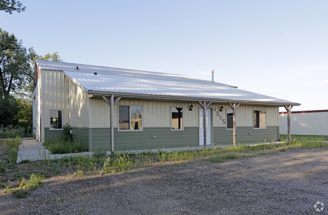
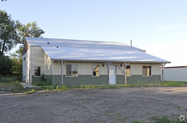
Property Record
4501 Memorial Hwy, Mandan, ND 58554

NEARBY LISTINGS FOR SALE OR LEASE
Property Detail
4501 Memorial Hwy
Bismarck, ND
Sylvesters Industrial Park 2Nd
65-5094000
TWN: 0 SCT: 0 RNG: 0 SUB: 206 BLK: 2 LOT: 7 8264
Residentialacreage
Morton
AE
North Dakota
38015C0790E
7
2024
1.32 AC
2024
Prairie West
020301
Other Market Areas
DEMOGRAPHICS near 4501 Memorial Hwy
1 Mile
3 Mile
5 Mile
2024 Total Population
5,662
47,976
96,078
2029 Population
5,930
49,553
99,183
Pop Growth 2024-2029
+ 4.73%
+ 3.29%
+ 3.23%
Average Age
39
40
40
2024 Total Households
2,493
21,118
41,354
HH Growth 2024-2029
+ 4.77%
+ 3.36%
+ 3.26%
Median Household Inc
$71,135
$63,616
$66,130
Avg Household Size
2.20
2.20
2.20
2024 Avg HH Vehicles
2.00
2.00
2.00
Median Home Value
$378,103
$255,269
$258,680
Median Year Built
2007
1978
1982
Nearby Places
Map Layers
Map Styles
 Street
 Aerial
- Restaurants
- Banks
- Shops
- Fitness
- Groceries
PUBLIC TRANSPORTATION
AIRPORT
Bismarck Municipal
DRIVE
WALK
Distance
Bismarck Municipal
19 min
6.6 mi
SALE & LEASE HISTORY
LISTING DATE
SALE/LEASE

Aug 11, 2017
For Lease
Nearby Properties
Address
Land Use
TOTAL SIZE
Lot Size
Zoning
Address
Land Use
TOTAL SIZE
Lot Size
Zoning
45.23 AC
CG
Address
Land Use
TOTAL SIZE
Lot Size
Zoning
13.47 AC
PUD
Address
Land Use
TOTAL SIZE
Lot Size
Zoning
93,860 SF
1.44 AC
HM
Address
Land Use
TOTAL SIZE
Lot Size
Zoning
70,182 SF
3.83 AC
PUD
Address
Land Use
TOTAL SIZE
Lot Size
Zoning
44,652 SF
13.84 AC
RM30
Address
Land Use
TOTAL SIZE
Lot Size
Zoning
81,092 SF
4.17 AC
HM
Address
Land Use
TOTAL SIZE
Lot Size
Zoning
38,467 SF
13.89 AC
CG
Address
Land Use
TOTAL SIZE
Lot Size
Zoning
13.98 AC
CG
Address
Land Use
TOTAL SIZE
Lot Size
Zoning
51,723 SF
1.69 AC
HM
Address
Land Use
TOTAL SIZE
Lot Size
Zoning
10.84 AC
CG
Address
Land Use
TOTAL SIZE
Lot Size
Zoning
57,580 SF
8.85 AC
CG
Address
Land Use
TOTAL SIZE
Lot Size
Zoning
8.64 AC
ETZ
Address
Land Use
TOTAL SIZE
Lot Size
Zoning
62,652 SF
2.34 AC
HM
Address
Land Use
TOTAL SIZE
Lot Size
Zoning
99,684 SF
2.33 AC
MA
Address
Land Use
TOTAL SIZE
Lot Size
Zoning
10.58 AC
CG
Address
Land Use
TOTAL SIZE
Lot Size
Zoning
10.14 AC
CG
Address
Land Use
TOTAL SIZE
Lot Size
Zoning
14.65 AC
CG
Address
Land Use
TOTAL SIZE
Lot Size
Zoning
81.73 AC
RMH
Address
Land Use
TOTAL SIZE
Lot Size
Zoning
88,263 SF
8.58 AC
CG
Address
Land Use
TOTAL SIZE
Lot Size
Zoning
48,661 SF
4.91 AC
CG
Address
Land Use
TOTAL SIZE
Lot Size
Zoning
68,211 SF
10 AC
RT
Address
Land Use
TOTAL SIZE
Lot Size
Zoning
27,636 SF
0.72 AC
DC
Address
Land Use
TOTAL SIZE
Lot Size
Zoning
40,876 SF
2.07 AC
CG
Address
Land Use
TOTAL SIZE
Lot Size
Zoning
8,280 SF
9.76 AC
RM30
Address
Land Use
TOTAL SIZE
Lot Size
Zoning
17,472 SF
3.76 AC
CG
Address
Land Use
TOTAL SIZE
Lot Size
Zoning
13,853 SF
0.78 AC
DC
Address
Land Use
TOTAL SIZE
Lot Size
Zoning
35,354 SF
3.75 AC
RT
Address
Land Use
TOTAL SIZE
Lot Size
Zoning
77,477 SF
3.43 AC
RM30
Address
Land Use
TOTAL SIZE
Lot Size
Zoning
72,245 SF
3.79 AC
CG
Address
Land Use
TOTAL SIZE
Lot Size
Zoning
34,611 SF
6.52 AC
RT
The World's #1 Commercial Real Estate Marketplace
Connect with us
© 2025 CoStar Group
The information above has been obtained from sources believed reliable. While we do not doubt its accuracy we have not verified it and make no guarantee, warranty or representation about it. It is your responsibility to independently confirm its accuracy and completeness. Any projections, opinions, assumptions, or estimates used are for example only and do not represent the current or future performance of the property. The value of this transaction to you depends on tax and other factors which should be evaluated by your tax, financial, and legal advisors. You and your advisors should conduct a careful, independent investigation of the property to determine to your satisfaction the suitability of the property for your needs.