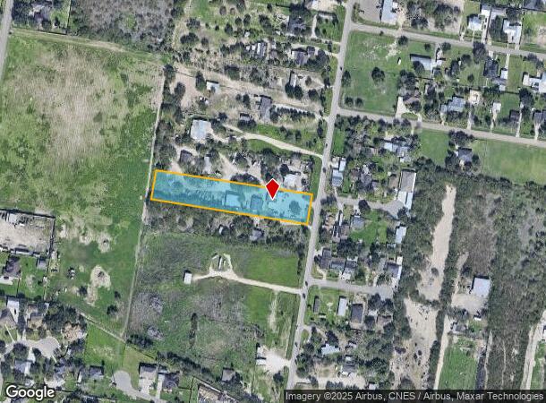
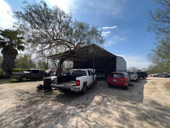
Property Record
4501 N Moorefield Rd, Mission, TX 78574

NEARBY LISTINGS FOR SALE OR LEASE
Property Detail
4501 N Moorefield Rd
McAllen/Edinburg/Pharr
Margot Estates
McAllen-Edinburg-Mission, TX
MARGOT ESTATES LOT 2
M1040-00-000-0002-00
Hidalgo
Commercialnec
Texas
2024
2
2025
1.66 AC
024118
Outlying Hidalgo County
308 SF
DEMOGRAPHICS near 4501 N Moorefield Rd
1 Mile
3 Mile
5 Mile
2024 Total Population
6,851
58,729
155,737
2029 Population
7,090
61,366
164,650
Pop Growth 2024-2029
+ 3.49%
+ 4.49%
+ 5.72%
Average Age
32
33
35
2024 Total Households
1,779
15,755
45,660
HH Growth 2024-2029
+ 3.26%
+ 4.41%
+ 6.06%
Median Household Inc
$39,791
$41,670
$42,877
Avg Household Size
3.70
3.60
3.30
2024 Avg HH Vehicles
2.00
2.00
2.00
Median Home Value
$132,084
$110,222
$99,148
Median Year Built
2000
1997
1998
Nearby Places
Map Layers
Map Styles
 Street
 Aerial
- Restaurants
- Banks
- Shops
- Fitness
- Groceries
PUBLIC TRANSPORTATION
AIRPORT
McAllen International
DRIVE
WALK
Distance
McAllen International
20 min
12.8 mi
Freight Ports
Port of Brownsville
DRIVE
WALK
Distance
Port of Brownsville
83 min
71.7 mi
SALE & LEASE HISTORY
LISTING DATE
SALE/LEASE

Mar 02, 2022
For Sale
Nearby Properties
Address
Land Use
TOTAL SIZE
Lot Size
Zoning
Address
Land Use
TOTAL SIZE
Lot Size
Zoning
2 SF
51.19 AC
CO
Address
Land Use
TOTAL SIZE
Lot Size
Zoning
207,520 SF
25.33 AC
Address
Land Use
TOTAL SIZE
Lot Size
Zoning
193,364 SF
19.62 AC
Address
Land Use
TOTAL SIZE
Lot Size
Zoning
120,856 SF
23.63 AC
Address
Land Use
TOTAL SIZE
Lot Size
Zoning
151,764 SF
34.37 AC
RS
Address
Land Use
TOTAL SIZE
Lot Size
Zoning
86,158 SF
18.26 AC
Address
Land Use
TOTAL SIZE
Lot Size
Zoning
431,740 SF
118.22 AC
Address
Land Use
TOTAL SIZE
Lot Size
Zoning
1 SF
14.12 AC
Address
Land Use
TOTAL SIZE
Lot Size
Zoning
16.71 AC
Address
Land Use
TOTAL SIZE
Lot Size
Zoning
104,727 SF
18.70 AC
Address
Land Use
TOTAL SIZE
Lot Size
Zoning
5 SF
32.59 AC
Address
Land Use
TOTAL SIZE
Lot Size
Zoning
88,785 SF
10.49 AC
Address
Land Use
TOTAL SIZE
Lot Size
Zoning
94,325 SF
18.58 AC
GT
Address
Land Use
TOTAL SIZE
Lot Size
Zoning
216,894 SF
14.62 AC
RM
Address
Land Use
TOTAL SIZE
Lot Size
Zoning
42.25 AC
GT
Address
Land Use
TOTAL SIZE
Lot Size
Zoning
4,000,000 SF
36.34 AC
Address
Land Use
TOTAL SIZE
Lot Size
Zoning
48,504 SF
14.61 AC
Address
Land Use
TOTAL SIZE
Lot Size
Zoning
3 SF
8.84 AC
Address
Land Use
TOTAL SIZE
Lot Size
Zoning
28.81 AC
GT
Address
Land Use
TOTAL SIZE
Lot Size
Zoning
2 SF
16.06 AC
Address
Land Use
TOTAL SIZE
Lot Size
Zoning
80,366 SF
8.85 AC
Address
Land Use
TOTAL SIZE
Lot Size
Zoning
19.39 AC
GT
Address
Land Use
TOTAL SIZE
Lot Size
Zoning
47,140 SF
5.86 AC
Address
Land Use
TOTAL SIZE
Lot Size
Zoning
34,623 SF
4.03 AC
Address
Land Use
TOTAL SIZE
Lot Size
Zoning
37,095 SF
9.45 AC
Address
Land Use
TOTAL SIZE
Lot Size
Zoning
22.72 AC
Address
Land Use
TOTAL SIZE
Lot Size
Zoning
43,060 SF
10.70 AC
Address
Land Use
TOTAL SIZE
Lot Size
Zoning
10,314 SF
39.76 AC
Address
Land Use
TOTAL SIZE
Lot Size
Zoning
127,275 SF
7.02 AC
CO
Address
Land Use
TOTAL SIZE
Lot Size
Zoning
45,180 SF
9.58 AC
The World's #1 Commercial Real Estate Marketplace
Connect with us
© 2026 CoStar Group
The information above has been obtained from sources believed reliable. While we do not doubt its accuracy we have not verified it and make no guarantee, warranty or representation about it. It is your responsibility to independently confirm its accuracy and completeness. Any projections, opinions, assumptions, or estimates used are for example only and do not represent the current or future performance of the property. The value of this transaction to you depends on tax and other factors which should be evaluated by your tax, financial, and legal advisors. You and your advisors should conduct a careful, independent investigation of the property to determine to your satisfaction the suitability of the property for your needs.