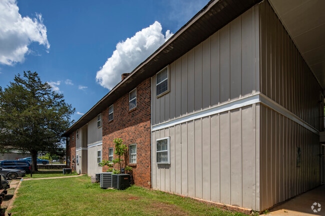
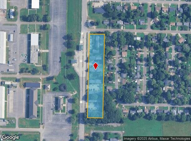
Property Record
4501 Patton Rd Sw, Huntsville, AL 35805

NEARBY LISTINGS FOR SALE OR LEASE
Property Detail
4501 Patton Rd Sw
17-05-15-3-004-024.000
SEC 15 T4S R1W COMM AT THE SW COR OF SEC 15 TH N 88 DEG E 20 FT TO THE POB TH N 853 FT N 88 DEG E 156.08 FT S 1 DEG E 853 FT
Quadruplex
Madison
X
Alabama
01089C0320F
3.11 AC
2025
West Huntsville
2025
Huntsville
002400
Huntsville, AL
3,074 SF
DEMOGRAPHICS near 4501 Patton Rd Sw
1 Mile
3 Mile
5 Mile
2024 Total Population
4,981
32,726
92,165
2029 Population
5,529
36,284
102,328
Pop Growth 2024-2029
+ 11.00%
+ 10.87%
+ 11.03%
Average Age
36
36
39
2024 Total Households
2,162
14,358
41,553
HH Growth 2024-2029
+ 11.47%
+ 11.39%
+ 11.54%
Median Household Inc
$33,118
$38,142
$51,362
Avg Household Size
2.20
2.10
2.00
2024 Avg HH Vehicles
1.00
1.00
2.00
Median Home Value
$71,249
$101,670
$237,708
Median Year Built
1977
1973
1975
Nearby Places
- Restaurants
- Banks
- Shops
- Fitness
- Groceries
PUBLIC TRANSPORTATION
AIRPORT
Huntsville International-Carl T Jones Field
DRIVE
WALK
Distance
Huntsville International-Carl T Jones Field
21 min
14.0 mi
Freight Ports
Port of Mobile
DRIVE
WALK
Distance
Port of Mobile
389 min
355.2 mi
Nearby Properties
Address
Land Use
TOTAL SIZE
Lot Size
Zoning
Address
Land Use
TOTAL SIZE
Lot Size
Zoning
208,719 SF
26.55 AC
Address
Land Use
TOTAL SIZE
Lot Size
Zoning
5,577 SF
12.72 AC
Address
Land Use
TOTAL SIZE
Lot Size
Zoning
31,050 SF
Address
Land Use
TOTAL SIZE
Lot Size
Zoning
56,426 SF
13.78 AC
Address
Land Use
TOTAL SIZE
Lot Size
Zoning
78,492 SF
Address
Land Use
TOTAL SIZE
Lot Size
Zoning
25,619 SF
Address
Land Use
TOTAL SIZE
Lot Size
Zoning
4,379 SF
18 AC
Address
Land Use
TOTAL SIZE
Lot Size
Zoning
25,619 SF
Address
Land Use
TOTAL SIZE
Lot Size
Zoning
25,619 SF
Address
Land Use
TOTAL SIZE
Lot Size
Zoning
76,079 SF
12.71 AC
Address
Land Use
TOTAL SIZE
Lot Size
Zoning
58,809 SF
9.90 AC
Address
Land Use
TOTAL SIZE
Lot Size
Zoning
64,650 SF
2 AC
Address
Land Use
TOTAL SIZE
Lot Size
Zoning
25,619 SF
Address
Land Use
TOTAL SIZE
Lot Size
Zoning
56,100 SF
63.13 AC
Address
Land Use
TOTAL SIZE
Lot Size
Zoning
Address
Land Use
TOTAL SIZE
Lot Size
Zoning
42,231 SF
6.69 AC
Address
Land Use
TOTAL SIZE
Lot Size
Zoning
31,946 SF
16.67 AC
Address
Land Use
TOTAL SIZE
Lot Size
Zoning
24,672 SF
0.54 AC
Address
Land Use
TOTAL SIZE
Lot Size
Zoning
24,672 SF
0.54 AC
Address
Land Use
TOTAL SIZE
Lot Size
Zoning
24,672 SF
0.54 AC
Address
Land Use
TOTAL SIZE
Lot Size
Zoning
19,360 SF
6.24 AC
Address
Land Use
TOTAL SIZE
Lot Size
Zoning
26,040 SF
Address
Land Use
TOTAL SIZE
Lot Size
Zoning
134,725 SF
Address
Land Use
TOTAL SIZE
Lot Size
Zoning
58,651 SF
3.70 AC
Address
Land Use
TOTAL SIZE
Lot Size
Zoning
18,404 SF
112 AC
Address
Land Use
TOTAL SIZE
Lot Size
Zoning
126,000 SF
Address
Land Use
TOTAL SIZE
Lot Size
Zoning
32,290 SF
3.05 AC
Address
Land Use
TOTAL SIZE
Lot Size
Zoning
27,009 SF
5.43 AC
Address
Land Use
TOTAL SIZE
Lot Size
Zoning
34,705 SF
1.89 AC
Address
Land Use
TOTAL SIZE
Lot Size
Zoning
8,580 SF
19.29 AC
The World's #1 Commercial Real Estate Marketplace
Connect with us
© 2025 CoStar Group
The information above has been obtained from sources believed reliable. While we do not doubt its accuracy we have not verified it and make no guarantee, warranty or representation about it. It is your responsibility to independently confirm its accuracy and completeness. Any projections, opinions, assumptions, or estimates used are for example only and do not represent the current or future performance of the property. The value of this transaction to you depends on tax and other factors which should be evaluated by your tax, financial, and legal advisors. You and your advisors should conduct a careful, independent investigation of the property to determine to your satisfaction the suitability of the property for your needs.