Property Record
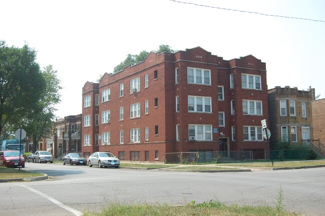
4501 W Maypole Ave, Chicago, IL 60624


NEARBY LISTINGS FOR SALE OR LEASE
Property Detail
4501 W Maypole Ave
16-10-321-007-0000
West Chicago Land Cos
Apartment
Cook
X
Illinois
17031C0415J
2,1
2023
0.15 AC
2024
West Garfield Park
260400
Chicago
10,569 SF
Chicago-Naperville-Elgin, IL-IN-WI
DEMOGRAPHICS near 4501 W Maypole Ave
1 Mile
3 Mile
5 Mile
2024 Total Population
30,041
346,212
925,104
2029 Population
28,003
322,088
871,144
Pop Growth 2024-2029
(6.78%)
(6.97%)
(5.83%)
Average Age
38
37
37
2024 Total Households
10,927
124,376
353,958
HH Growth 2024-2029
(7.26%)
(7.18%)
(5.82%)
Median Household Inc
$34,803
$50,702
$71,331
Avg Household Size
2.60
2.70
2.50
2024 Avg HH Vehicles
1.00
1.00
1.00
Median Home Value
$198,614
$279,698
$343,434
Median Year Built
1947
1947
1948
Nearby Places
Map Layers
Map Styles
 Street
 Aerial
- Restaurants
- Banks
- Shops
- Fitness
- Groceries
PUBLIC TRANSPORTATION
TRANSIT/SUBWAY
Cicero Station (Green Line) (Green Line - Chicago Transit Authority "L" Trains (The "L"))
DRIVE
WALK
Distance
Cicero Station (Green Line) (Green Line - Chicago Transit Authority "L" Trains (The "L"))
1 min
8 min
0.5 mi
Pulaski Station (Green Line) (Green Line - Chicago Transit Authority "L" Trains (The "L"))
DRIVE
WALK
Distance
Pulaski Station (Green Line) (Green Line - Chicago Transit Authority "L" Trains (The "L"))
2 min
13 min
0.7 mi
COMMUTER RAIL
Kedzie Station (Union Pacific West Line - Northeast Illinois Regional Commuter Railroad (Metra))
DRIVE
WALK
Distance
Kedzie Station (Union Pacific West Line - Northeast Illinois Regional Commuter Railroad (Metra))
5 min
2.2 mi
Grand/Cicero Station (Milwaukee District West Line - Northeast Illinois Regional Commuter Railroad (Metra), North Central Service - Northeast Illinois Regional Commuter Railroad (Metra))
DRIVE
WALK
Distance
Grand/Cicero Station (Milwaukee District West Line - Northeast Illinois Regional Commuter Railroad (Metra), North Central Service - Northeast Illinois Regional Commuter Railroad (Metra))
7 min
2.6 mi
AIRPORT
Chicago Midway International
DRIVE
WALK
Distance
Chicago Midway International
13 min
7.2 mi
Chicago O'Hare International
DRIVE
WALK
Distance
Chicago O'Hare International
28 min
15.8 mi
Freight Ports
Port Milwaukee
DRIVE
WALK
Distance
Port Milwaukee
106 min
84.0 mi
SALE & LEASE HISTORY
LISTING DATE
SALE/LEASE

Sep 10, 2020
For Sale
May 27, 2022
For Sale
Nearby Properties
Address
Land Use
TOTAL SIZE
Lot Size
Zoning
Address
Land Use
TOTAL SIZE
Lot Size
Zoning
73,700 SF
0.48 AC
RM-6.5
Address
Land Use
TOTAL SIZE
Lot Size
Zoning
86,928 SF
4.80 AC
PD 933
Address
Land Use
TOTAL SIZE
Lot Size
Zoning
0.66 AC
RS-3
Address
Land Use
TOTAL SIZE
Lot Size
Zoning
1,313,541 SF
44.90 AC
M2-2
Address
Land Use
TOTAL SIZE
Lot Size
Zoning
4.85 AC
PD 1505
Address
Land Use
TOTAL SIZE
Lot Size
Zoning
1,220,173 SF
26.53 AC
M2-2
Address
Land Use
TOTAL SIZE
Lot Size
Zoning
6.31 AC
PD 1013
Address
Land Use
TOTAL SIZE
Lot Size
Zoning
3.33 AC
PD 1013
Address
Land Use
TOTAL SIZE
Lot Size
Zoning
32,500 SF
0.56 AC
RT-4
Address
Land Use
TOTAL SIZE
Lot Size
Zoning
194,582 SF
12.68 AC
PD 699
Address
Land Use
TOTAL SIZE
Lot Size
Zoning
382,635 SF
5.90 AC
M1-1
Address
Land Use
TOTAL SIZE
Lot Size
Zoning
0.58 AC
B3-2
Address
Land Use
TOTAL SIZE
Lot Size
Zoning
291,681 SF
14.04 AC
Address
Land Use
TOTAL SIZE
Lot Size
Zoning
10,400 SF
0.20 AC
B3-5
Address
Land Use
TOTAL SIZE
Lot Size
Zoning
226,155 SF
5.86 AC
PMD 9
Address
Land Use
TOTAL SIZE
Lot Size
Zoning
578,024 SF
31.94 AC
Address
Land Use
TOTAL SIZE
Lot Size
Zoning
0.66 AC
PD 852
Address
Land Use
TOTAL SIZE
Lot Size
Zoning
93,409 SF
2.05 AC
PD 146
Address
Land Use
TOTAL SIZE
Lot Size
Zoning
389,400 SF
28.83 AC
PMD 9
Address
Land Use
TOTAL SIZE
Lot Size
Zoning
1,300 SF
0.07 AC
B3-5
Address
Land Use
TOTAL SIZE
Lot Size
Zoning
9,000 SF
0.34 AC
Address
Land Use
TOTAL SIZE
Lot Size
Zoning
7.68 AC
Address
Land Use
TOTAL SIZE
Lot Size
Zoning
900 SF
29.73 AC
PD 1454
Address
Land Use
TOTAL SIZE
Lot Size
Zoning
0.41 AC
RT-4
Address
Land Use
TOTAL SIZE
Lot Size
Zoning
15.25 AC
Address
Land Use
TOTAL SIZE
Lot Size
Zoning
179,150 SF
15.56 AC
PD 903
Address
Land Use
TOTAL SIZE
Lot Size
Zoning
0.70 AC
PD 9
Address
Land Use
TOTAL SIZE
Lot Size
Zoning
8.92 AC
Address
Land Use
TOTAL SIZE
Lot Size
Zoning
149,587 SF
2.47 AC
M2-2
Address
Land Use
TOTAL SIZE
Lot Size
Zoning
493,554 SF
11.55 AC
PMD-4
The World's #1 Commercial Real Estate Marketplace
Connect with us
© 2025 CoStar Group
The information above has been obtained from sources believed reliable. While we do not doubt its accuracy we have not verified it and make no guarantee, warranty or representation about it. It is your responsibility to independently confirm its accuracy and completeness. Any projections, opinions, assumptions, or estimates used are for example only and do not represent the current or future performance of the property. The value of this transaction to you depends on tax and other factors which should be evaluated by your tax, financial, and legal advisors. You and your advisors should conduct a careful, independent investigation of the property to determine to your satisfaction the suitability of the property for your needs.