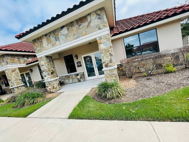
Property Record
4502 Riverstone Blvd, Missouri City, TX 77459

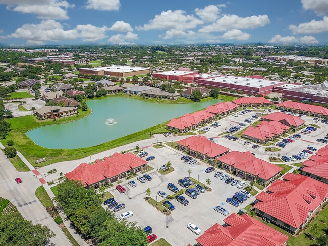

NEARBY LISTINGS FOR SALE OR LEASE
Property Detail
4502 Riverstone Blvd
1005-01-006-0604-907
4502 Riverstone Boulevard
Commercialnec
4502 RIVERSTONE BOULEVARD, AN OFFICE CONDOMINIUM, BUILDING 6, UNIT 604, 1.7857% COMMON AREA INTEREST, PHASE ONE, TWO & THREE 6.693 ACRES
X
Fort Bend
48157C0280L
Texas
2024
0.09 AC
2025
E Fort Bend Co/Sugar Land
674302
Houston
1,187 SF
Houston-The Woodlands-Sugar Land, TX
DEMOGRAPHICS near 4502 Riverstone Blvd
1 Mile
3 Mile
5 Mile
2024 Total Population
10,969
107,077
201,461
2029 Population
13,062
128,118
241,432
Pop Growth 2024-2029
+ 19.08%
+ 19.65%
+ 19.84%
Average Age
42
40
40
2024 Total Households
3,583
36,371
69,391
HH Growth 2024-2029
+ 19.68%
+ 20.24%
+ 20.47%
Median Household Inc
$117,192
$99,411
$94,196
Avg Household Size
3.00
2.90
2.90
2024 Avg HH Vehicles
2.00
2.00
2.00
Median Home Value
$357,258
$330,910
$326,621
Median Year Built
1999
1995
1995
Nearby Places
Map Layers
Map Styles
 Street
 Aerial
- Restaurants
- Banks
- Shops
- Fitness
- Groceries
PUBLIC TRANSPORTATION
AIRPORT
William P Hobby
DRIVE
WALK
Distance
William P Hobby
41 min
24.5 mi
George Bush Intcntl/Houston
DRIVE
WALK
Distance
George Bush Intcntl/Houston
57 min
43.0 mi
Freight Ports
Port of Houston
DRIVE
WALK
Distance
Port of Houston
43 min
27.4 mi
SALE & LEASE HISTORY
LISTING DATE
SALE/LEASE

Nov 13, 2017
For Sale
May 19, 2017
For Lease
May 18, 2021
For Sale
Jan 04, 2024
For Lease
Jan 03, 2018
For Lease
Feb 24, 2021
For Lease
Feb 14, 2017
For Lease
Aug 22, 2019
For Lease
Nearby Properties
Address
Land Use
TOTAL SIZE
Lot Size
Zoning
Address
Land Use
TOTAL SIZE
Lot Size
Zoning
16.84 AC
Address
Land Use
TOTAL SIZE
Lot Size
Zoning
365,915 SF
57.06 AC
AT
Address
Land Use
TOTAL SIZE
Lot Size
Zoning
254,919 SF
12.46 AC
Address
Land Use
TOTAL SIZE
Lot Size
Zoning
14,038 SF
23.83 AC
Address
Land Use
TOTAL SIZE
Lot Size
Zoning
6.70 AC
Address
Land Use
TOTAL SIZE
Lot Size
Zoning
Address
Land Use
TOTAL SIZE
Lot Size
Zoning
127,458 SF
14.21 AC
Address
Land Use
TOTAL SIZE
Lot Size
Zoning
149,261 SF
12.15 AC
SJ
Address
Land Use
TOTAL SIZE
Lot Size
Zoning
Address
Land Use
TOTAL SIZE
Lot Size
Zoning
88,560 SF
10.25 AC
QZ
Address
Land Use
TOTAL SIZE
Lot Size
Zoning
9.10 AC
Address
Land Use
TOTAL SIZE
Lot Size
Zoning
244,617 SF
9.34 AC
Address
Land Use
TOTAL SIZE
Lot Size
Zoning
189,336 SF
42.18 AC
MJT
Address
Land Use
TOTAL SIZE
Lot Size
Zoning
128,226 SF
11.40 AC
S
Address
Land Use
TOTAL SIZE
Lot Size
Zoning
189,336 SF
25.53 AC
S
Address
Land Use
TOTAL SIZE
Lot Size
Zoning
966,869 SF
16.14 AC
Address
Land Use
TOTAL SIZE
Lot Size
Zoning
120,046 SF
10.19 AC
QSXA
Address
Land Use
TOTAL SIZE
Lot Size
Zoning
65,653 SF
5 AC
X
Address
Land Use
TOTAL SIZE
Lot Size
Zoning
12.22 AC
OS
Address
Land Use
TOTAL SIZE
Lot Size
Zoning
73,196 SF
19.52 AC
SH
Address
Land Use
TOTAL SIZE
Lot Size
Zoning
126,941 SF
11.08 AC
Address
Land Use
TOTAL SIZE
Lot Size
Zoning
Address
Land Use
TOTAL SIZE
Lot Size
Zoning
193,365 SF
18.26 AC
Address
Land Use
TOTAL SIZE
Lot Size
Zoning
14.76 AC
Address
Land Use
TOTAL SIZE
Lot Size
Zoning
124,342 SF
15.55 AC
Address
Land Use
TOTAL SIZE
Lot Size
Zoning
50,669 SF
22.59 AC
XSH
Address
Land Use
TOTAL SIZE
Lot Size
Zoning
18.90 AC
ATSN
Address
Land Use
TOTAL SIZE
Lot Size
Zoning
3.02 AC
Address
Land Use
TOTAL SIZE
Lot Size
Zoning
12.49 AC
QA
Address
Land Use
TOTAL SIZE
Lot Size
Zoning
The World's #1 Commercial Real Estate Marketplace
Connect with us
© 2026 CoStar Group
The information above has been obtained from sources believed reliable. While we do not doubt its accuracy we have not verified it and make no guarantee, warranty or representation about it. It is your responsibility to independently confirm its accuracy and completeness. Any projections, opinions, assumptions, or estimates used are for example only and do not represent the current or future performance of the property. The value of this transaction to you depends on tax and other factors which should be evaluated by your tax, financial, and legal advisors. You and your advisors should conduct a careful, independent investigation of the property to determine to your satisfaction the suitability of the property for your needs.