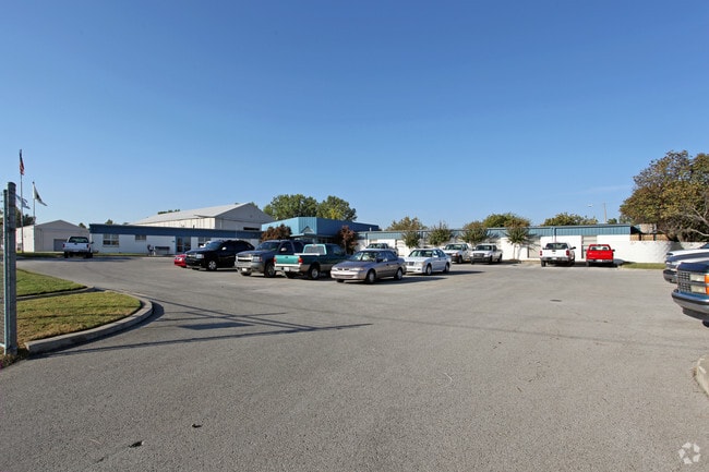
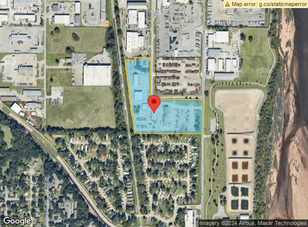
Property Record
4502 S Galveston Ave, Tulsa, OK 74107

NEARBY LISTINGS FOR SALE OR LEASE
Property Detail
4502 S Galveston Ave
99226-92-26-12510
Unplatted
Warehouse
BEG SECR SE NE TH W874.69 TO ELY R/W RR TH NLY934.97 TO PT 1704.29 SLY AS MEASURED ALG ELY RR R/W FROM PT 25S NL SEC TH E146.04 N28.20 E192.72 TO PT 1681.50S NL SEC TH S ALG W BDRY ST 523.24 E660 S435 POB SEC 26 19 12 12.624ACS
X
Tulsa
40143C0351L
Oklahoma
0
12.62 AC
2025
West
004900
Tulsa
57,239 SF
Tulsa, OK
DEMOGRAPHICS near 4502 S Galveston Ave
1 Mile
3 Mile
5 Mile
2024 Total Population
3,311
61,492
166,331
2029 Population
3,453
63,875
173,037
Pop Growth 2024-2029
+ 4.29%
+ 3.88%
+ 4.03%
Average Age
40
40
39
2024 Total Households
1,593
28,974
74,744
HH Growth 2024-2029
+ 4.21%
+ 3.98%
+ 4.17%
Median Household Inc
$47,500
$53,664
$54,163
Avg Household Size
2.00
2.00
2.10
2024 Avg HH Vehicles
2.00
2.00
2.00
Median Home Value
$116,377
$220,058
$202,997
Median Year Built
1960
1967
1967
Nearby Places
Map Layers
Map Styles
 Street
 Aerial
- Restaurants
- Banks
- Shops
- Fitness
- Groceries
PUBLIC TRANSPORTATION
AIRPORT
Tulsa International
DRIVE
WALK
Distance
Tulsa International
23 min
14.2 mi
Freight Ports
DRIVE
WALK
Distance
30 min
22.2 mi
Nearby Properties
Address
Land Use
TOTAL SIZE
Lot Size
Zoning
Address
Land Use
TOTAL SIZE
Lot Size
Zoning
1,303,210 SF
7.94 AC
OH
Address
Land Use
TOTAL SIZE
Lot Size
Zoning
49,992 SF
33.23 AC
AG
Address
Land Use
TOTAL SIZE
Lot Size
Zoning
114,791 SF
23.40 AC
RE
Address
Land Use
TOTAL SIZE
Lot Size
Zoning
238,884 SF
38.79 AC
RS2
Address
Land Use
TOTAL SIZE
Lot Size
Zoning
310,629 SF
19.19 AC
OM
Address
Land Use
TOTAL SIZE
Lot Size
Zoning
290,963 SF
10.77 AC
RM1
Address
Land Use
TOTAL SIZE
Lot Size
Zoning
303 SF
33.64 AC
RS2
Address
Land Use
TOTAL SIZE
Lot Size
Zoning
266,675 SF
12.31 AC
RM1
Address
Land Use
TOTAL SIZE
Lot Size
Zoning
119,056 SF
28.06 AC
CM
Address
Land Use
TOTAL SIZE
Lot Size
Zoning
147,881 SF
35.20 AC
RS2
Address
Land Use
TOTAL SIZE
Lot Size
Zoning
137,215 SF
5.08 AC
RM3
Address
Land Use
TOTAL SIZE
Lot Size
Zoning
88,702 SF
8.27 AC
IM
Address
Land Use
TOTAL SIZE
Lot Size
Zoning
21,693 SF
4.24 AC
Address
Land Use
TOTAL SIZE
Lot Size
Zoning
62,000 SF
7.20 AC
OM
Address
Land Use
TOTAL SIZE
Lot Size
Zoning
106,743 SF
4.34 AC
MX1U55
Address
Land Use
TOTAL SIZE
Lot Size
Zoning
15.98 AC
OMH
Address
Land Use
TOTAL SIZE
Lot Size
Zoning
89,640 SF
5.47 AC
MX1U55
Address
Land Use
TOTAL SIZE
Lot Size
Zoning
100,857 SF
4.04 AC
MX1U55
Address
Land Use
TOTAL SIZE
Lot Size
Zoning
132,105 SF
9.32 AC
RS3
Address
Land Use
TOTAL SIZE
Lot Size
Zoning
28,953 SF
10.32 AC
RS2
Address
Land Use
TOTAL SIZE
Lot Size
Zoning
78,442 SF
31.24 AC
IM
Address
Land Use
TOTAL SIZE
Lot Size
Zoning
495,226 SF
27.47 AC
CH
Address
Land Use
TOTAL SIZE
Lot Size
Zoning
53,220 SF
4.93 AC
CH
Address
Land Use
TOTAL SIZE
Lot Size
Zoning
589,648 SF
2.84 AC
RM3
Address
Land Use
TOTAL SIZE
Lot Size
Zoning
11,349 SF
0.61 AC
RM2
Address
Land Use
TOTAL SIZE
Lot Size
Zoning
330,521 SF
22.04 AC
PUD
Address
Land Use
TOTAL SIZE
Lot Size
Zoning
84,791 SF
8.04 AC
RS3
Address
Land Use
TOTAL SIZE
Lot Size
Zoning
1,123,266 SF
87.29 AC
IM
Address
Land Use
TOTAL SIZE
Lot Size
Zoning
110,382 SF
9.81 AC
RS3
Address
Land Use
TOTAL SIZE
Lot Size
Zoning
35,845 SF
14.38 AC
CS
The World's #1 Commercial Real Estate Marketplace
Connect with us
© 2026 CoStar Group
The information above has been obtained from sources believed reliable. While we do not doubt its accuracy we have not verified it and make no guarantee, warranty or representation about it. It is your responsibility to independently confirm its accuracy and completeness. Any projections, opinions, assumptions, or estimates used are for example only and do not represent the current or future performance of the property. The value of this transaction to you depends on tax and other factors which should be evaluated by your tax, financial, and legal advisors. You and your advisors should conduct a careful, independent investigation of the property to determine to your satisfaction the suitability of the property for your needs.