Property Record
4504 Eugene Ware Blvd, Bastrop, LA 71220
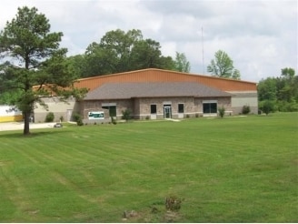

Property Detail
4504 Eugene Ware Blvd
Monroe, LA
FROM THE SE CORNER OF LOT 1 OF THE GRICE TRACT PER PLAT BK 1 PG 104, THENCE RUN N 47 DEG 29 MIN 51 SEC W ALONG SW LINE OF LOT
904005404
Morehouse
Commercialnec
Louisiana
2025
137
2025
1.55 AC
950400
Other Market Areas
23,284 SF
NEARBY LISTINGS FOR SALE OR LEASE
-
-
View all Bastrop listings for sale on LoopNet.com
DEMOGRAPHICS near 4504 Eugene Ware Blvd
1 mile
3 mile
5 mile
2024 Total Population
1,817
10,798
15,115
2029 Population
1,745
10,362
14,417
Pop Growth 2024-2029
(3.96%)
(4.04%)
(4.62%)
Average Age
38
40
41
2024 Total Households
666
4,295
6,011
HH Growth 2024-2029
(4.05%)
(4.14%)
(4.77%)
Median Household Inc
$27,211
$31,322
$34,397
Avg Household Size
2.50
2.40
2.40
2024 Avg HH Vehicles
1.00
2.00
2.00
Median Home Value
$73,304
$91,283
$104,000
Median Year Built
1977
1973
1974
Nearby Places
Map Layers
Map Styles
 Street
 Aerial
Transit
 Traffic
 Biking
Places
Listings with unknown addresses are not visible on the map
- Restaurants
- Banks
- Shops
- Fitness
- Groceries
PUBLIC TRANSPORTATION
AIRPORT
Monroe Regional
Drive
Walk
Distance
Monroe Regional
31 min
24.5 mi
Freight Ports
Port of Shreveport
Drive
Walk
Distance
Port of Shreveport
157 min
134.9 mi
Nearby Properties
Address
Land Use
TOTAL SIZE
Lot Size
Zoning
Address
Land Use
TOTAL SIZE
Lot Size
Zoning
61,904 SF
4.51 AC
Address
Land Use
TOTAL SIZE
Lot Size
Zoning
Address
Land Use
TOTAL SIZE
Lot Size
Zoning
0.61 AC
Address
Land Use
TOTAL SIZE
Lot Size
Zoning
Address
Land Use
TOTAL SIZE
Lot Size
Zoning
153,814 SF
6.17 AC
Address
Land Use
TOTAL SIZE
Lot Size
Zoning
100,393 SF
21.56 AC
Address
Land Use
TOTAL SIZE
Lot Size
Zoning
0.11 AC
Address
Land Use
TOTAL SIZE
Lot Size
Zoning
Address
Land Use
TOTAL SIZE
Lot Size
Zoning
50,822 SF
3.45 AC
Address
Land Use
TOTAL SIZE
Lot Size
Zoning
40,915 SF
25 AC
Address
Land Use
TOTAL SIZE
Lot Size
Zoning
Address
Land Use
TOTAL SIZE
Lot Size
Zoning
Address
Land Use
TOTAL SIZE
Lot Size
Zoning
29.02 AC
Address
Land Use
TOTAL SIZE
Lot Size
Zoning
10,322 SF
12.69 AC
Address
Land Use
TOTAL SIZE
Lot Size
Zoning
Address
Land Use
TOTAL SIZE
Lot Size
Zoning
58,378 SF
0.25 AC
Address
Land Use
TOTAL SIZE
Lot Size
Zoning
46,606 SF
9 AC
Address
Land Use
TOTAL SIZE
Lot Size
Zoning
57,725 SF
6 AC
Address
Land Use
TOTAL SIZE
Lot Size
Zoning
23,552 SF
4 AC
Address
Land Use
TOTAL SIZE
Lot Size
Zoning
49,414 SF
11 AC
Address
Land Use
TOTAL SIZE
Lot Size
Zoning
49,419 SF
2.89 AC
Address
Land Use
TOTAL SIZE
Lot Size
Zoning
69,640 SF
21 AC
Address
Land Use
TOTAL SIZE
Lot Size
Zoning
29,809 SF
83 AC
Address
Land Use
TOTAL SIZE
Lot Size
Zoning
46,441 SF
2.61 AC
Address
Land Use
TOTAL SIZE
Lot Size
Zoning
14,814 SF
0.97 AC
Address
Land Use
TOTAL SIZE
Lot Size
Zoning
33,176 SF
0.45 AC
Address
Land Use
TOTAL SIZE
Lot Size
Zoning
4.02 AC
Address
Land Use
TOTAL SIZE
Lot Size
Zoning
55,046 SF
9 AC
Address
Land Use
TOTAL SIZE
Lot Size
Zoning
26,379 SF
0.60 AC
Address
Land Use
TOTAL SIZE
Lot Size
Zoning
28,920 SF
8.99 AC
The World's #1 Commercial Real Estate Marketplace
Connect with us
© 2026 CoStar Group
The information above has been obtained from sources believed reliable. While we do not doubt its accuracy we have not verified it and make no guarantee, warranty or representation about it. It is your responsibility to independently confirm its accuracy and completeness. Any projections, opinions, assumptions, or estimates used are for example only and do not represent the current or future performance of the property. The value of this transaction to you depends on tax and other factors which should be evaluated by your tax, financial, and legal advisors. You and your advisors should conduct a careful, independent investigation of the property to determine to your satisfaction the suitability of the property for your needs.